

Průměrný učitel vypráví. Dobrý učitel vysvětluje. Výborný učitel ukazuje. Nejlepší učitel inspiruje.
Charles Farrar Browne
Konference
Konference v roce 2015
Konference v roce 2014
Konference v roce 2013
Konference v roce 2012
Konference v roce 2011


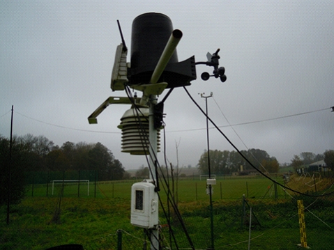
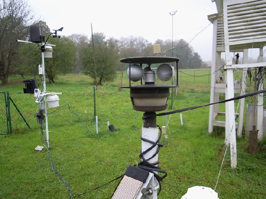
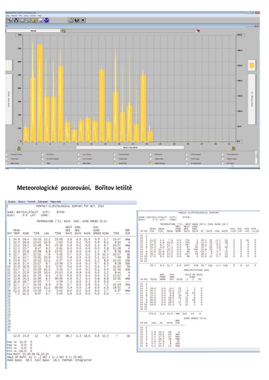
Polní laboratoř
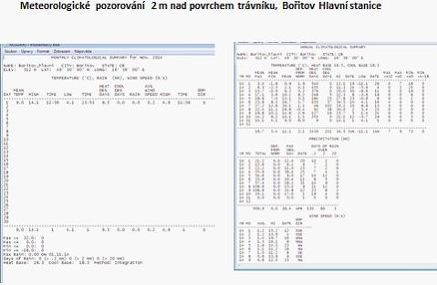
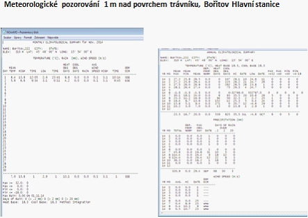
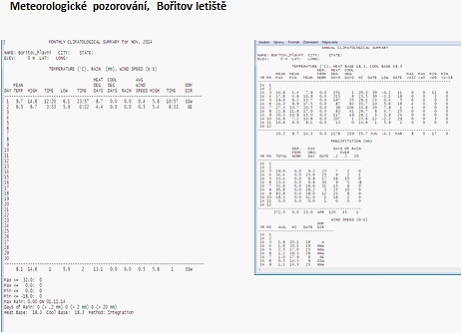
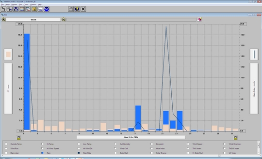
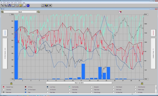
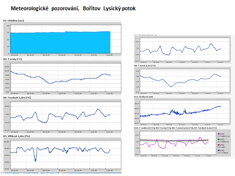
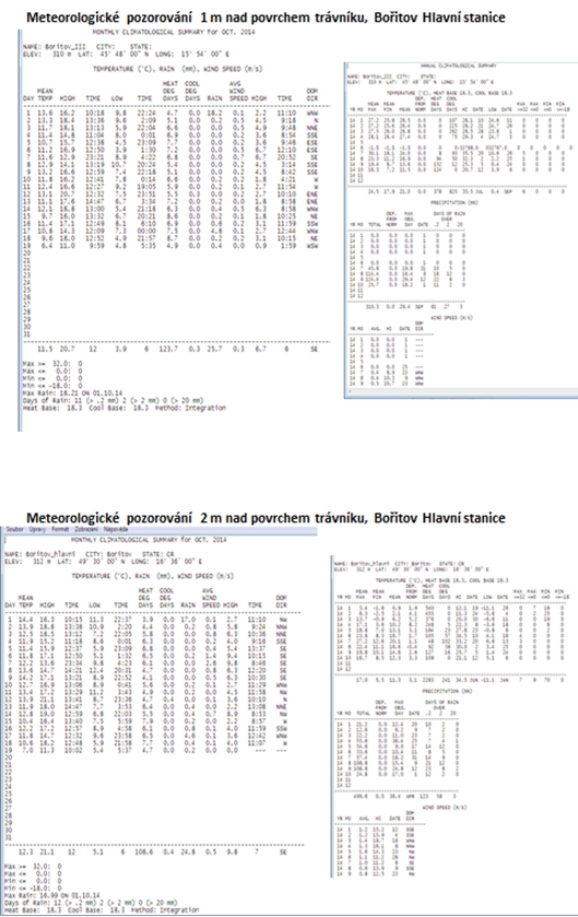
Informace z polní laboratoře – Bořitov
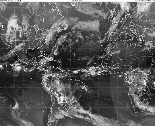
 Aktuální stav stanice 2. 11. 2014, 10:00 UTC, nízká oblačnost, Stratus fractus 80 m, mlha a mlhové pásy, dohlednost 0,75 km


NASA See Birth of Tropical Cyclone 5B in Bay of Bengal
 The fifth tropical cyclone of the Northern Indian Ocean season formed in the Bay of Bengal as NASA's Terra satellite passed overhead and captured an image of the storm.
When Terra passed over Tropical Cyclone 5B on Nov. 6 at 05:05 UTC (12:05 a.m. EST), the MODIS instrument aboard took a visible image of the storm. The MODIS image showed a concentrated storm with strong thunderstorms circling tight around the center and in the northeastern quadrant.
By 1500 UTC (10 a.m. EST), Tropical Cyclone 5B was located near 13.4 north latitude and 87.9 east longitude. That's about 380 nautical miles (437.3 miles/703.8 km) southeast of Visakhapatnam, India. Tropical Cyclone 5B had maximum sustained winds near 35 knots (40.2 mph/64.8 kph). It was moving slowly to the south-southeast.
Forecasters at the Joint Typhoon Warning Center said that an upper-level (atmospheric) analysis indicates the system remains in a generally favorable environment with moderate vertical wind shear and good outflow. Additionally, sea surface temperatures are relatively high in this region, which will help it maintain strength and slightly intensify over the next two days.
JWTC forecasters expect Tropical Cyclone 5B to make landfall near Chennai on Nov. 9 and dissipate over land quickly
The fifth tropical cyclone of the Northern Indian Ocean season formed in the Bay of Bengal as NASA's Terra satellite passed overhead and captured an image of the storm.
When Terra passed over Tropical Cyclone 5B on Nov. 6 at 05:05 UTC (12:05 a.m. EST), the MODIS instrument aboard took a visible image of the storm. The MODIS image showed a concentrated storm with strong thunderstorms circling tight around the center and in the northeastern quadrant.
By 1500 UTC (10 a.m. EST), Tropical Cyclone 5B was located near 13.4 north latitude and 87.9 east longitude. That's about 380 nautical miles (437.3 miles/703.8 km) southeast of Visakhapatnam, India. Tropical Cyclone 5B had maximum sustained winds near 35 knots (40.2 mph/64.8 kph). It was moving slowly to the south-southeast.
Forecasters at the Joint Typhoon Warning Center said that an upper-level (atmospheric) analysis indicates the system remains in a generally favorable environment with moderate vertical wind shear and good outflow. Additionally, sea surface temperatures are relatively high in this region, which will help it maintain strength and slightly intensify over the next two days.
JWTC forecasters expect Tropical Cyclone 5B to make landfall near Chennai on Nov. 9 and dissipate over land quickly
NASA Sees Tropical Storm Nuri Resemble a Frontal System
 NASA's Terra satellite passed over Tropical Storm Nuri on Nov. at captured an infrared picture of the storm. The storm looked more like a frontal system as it stretched from northeast to southwest.
The Moderate Resolution Imaging Spectroradiometer or MODIS instrument that flies aboard NASA's Terra satellite flew over Nuri on Nov. 6 at 1240 UTC (7:40 a.m. EST). The MODIS image showed some strong thunderstorms remaining in a small area around Nuri's center, but the storm appeared stretched out from northeast to southwest. Wind shear was affecting the storm, stretching it out.
The last bulletin on the storm was issued on Nov. 6 at 0300 UTC (Nov. 5 at 10 p.m. EST). At that time, the Joint Typhoon Warning Center (JTWC) noted that Nuri still had maximum sustained winds near 55 knots (63.2 mph/102 kph). It was located about 130 nautical miles (149 miles/240 km) west-northwest of Chichi-jima, near 29.2 north latitude and 141.0 east longitude. Nuri was moving to the northeast and over open waters of the western North Pacific.
In its final bulletin, JWTC noted that Nuri will become an extra-tropical storm before the end of the day on Nov. 6. Computer models indicate the system will be a strong extra-tropical low pressure area as it continues to move over open waters.
NASA's Terra satellite passed over Tropical Storm Nuri on Nov. at captured an infrared picture of the storm. The storm looked more like a frontal system as it stretched from northeast to southwest.
The Moderate Resolution Imaging Spectroradiometer or MODIS instrument that flies aboard NASA's Terra satellite flew over Nuri on Nov. 6 at 1240 UTC (7:40 a.m. EST). The MODIS image showed some strong thunderstorms remaining in a small area around Nuri's center, but the storm appeared stretched out from northeast to southwest. Wind shear was affecting the storm, stretching it out.
The last bulletin on the storm was issued on Nov. 6 at 0300 UTC (Nov. 5 at 10 p.m. EST). At that time, the Joint Typhoon Warning Center (JTWC) noted that Nuri still had maximum sustained winds near 55 knots (63.2 mph/102 kph). It was located about 130 nautical miles (149 miles/240 km) west-northwest of Chichi-jima, near 29.2 north latitude and 141.0 east longitude. Nuri was moving to the northeast and over open waters of the western North Pacific.
In its final bulletin, JWTC noted that Nuri will become an extra-tropical storm before the end of the day on Nov. 6. Computer models indicate the system will be a strong extra-tropical low pressure area as it continues to move over open waters.
Archiv
38_201437_2014
36_2014
35_2014
34_2014
33_2014
32_2014
31_2014
30_2014
29_2014
29_2014
28_2014
27_2014
26_2014
26_2014
25_2014
24_2014
23_2014
22_2014
21_2014
20_2014
20_2014
20_2014
19_2014
18_2014
17_2014
16_2014
15_2014
14_2014
54_2013
53_2013
52_2013
51_2013
50_2013
49_2013
48_2013
47_2013
46_2013
45_2013
44_2013
43_2013
42_2013
41_2013
40_2013
39_2013
38_2013
37_2013
36_2013
35_2013
34_2013
33_2013
32_2013
31_2013
30_2013
29_2013
28_2013
27_2013
26_2013
25_2013
24_2013
23_2013
22_2013
21_2013
20_2013
19_2013
18_2013
17_2013
16_2013
15_2013
14_2013
13_2013
12_2013
11_2013
10_2013
09_2013
08_2013
07_2013
06_2013
05_2013
04_2013
03_2013
02_2013
01_2013

 | Zemědělská 1/1665 613 00 Brno Budova D | Tel.: +420 545 133 350 Fax.: +420 545 212 044 |  |
 |