

Učit se znamená objevovat to, co už víš.
Konat znamená demonstrovat, že to to víš.
Učit druhé znamená připomínat jim, že to vědí stejně dobře jako ty.
Všichni jste zároveň žáci, praktikanti a učitelé.
Richard Bach
Konference
Konference v roce 2015
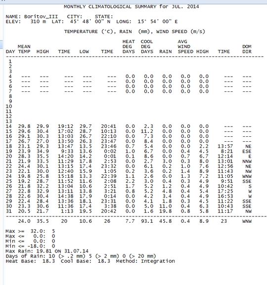
Konference v roce 2014
Konference v roce 2013
Konference v roce 2012
Konference v roce 2011


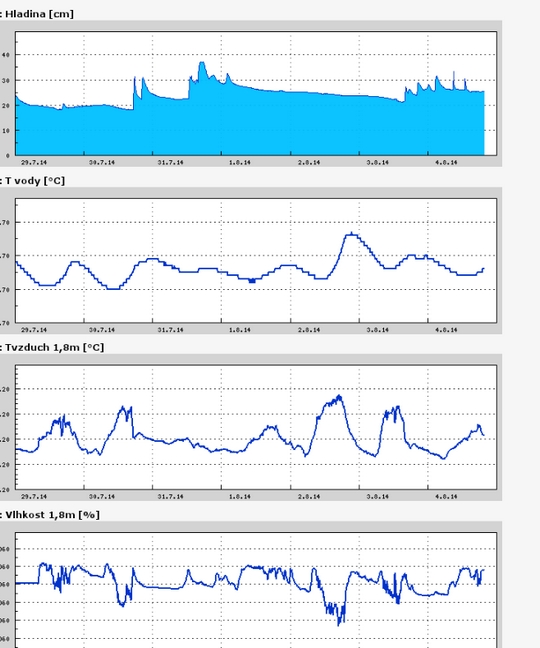
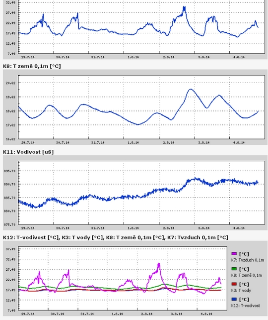
Polní laboratoř
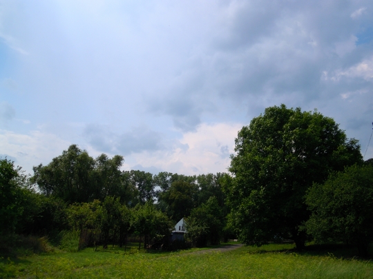
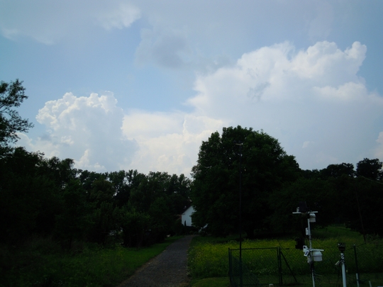
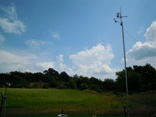
 Výrazně vyvinutý Cumulonibus, mezi oblaky altosumulus a stratocumulus 3. 8 . 2014, 10:10 UTC, NEN, začátek bouřky
 Cumulus fractus, Cumulus congestus, Cumulonimbus, 3. 8 . 2014, 10:10 UTC, W, začátek bouřky
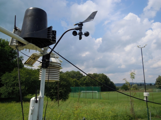
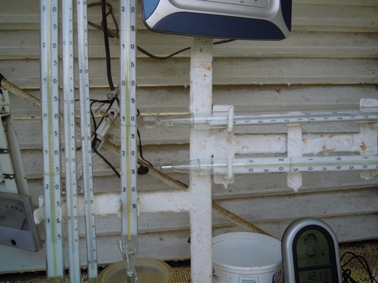 Vybavení standardní meteorologické budky staničními teploměry, maximálním a minimálním teploměrem. Foto 3. 8. 2014 v 10:11 UTC
 Cumulus mediocris, Cumulus humilis, Acumulus lenticularis, Cumulus fractus, 27. 7. 2014 14:45 UTC
NASA Catches the Brief Life of Tropical Storm Nakri
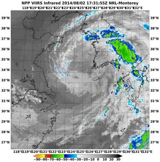 The low pressure area known as System 96W struggled to organize for a week and finally became Tropical Storm Nakri on August 2 as the Suomi NPP satellite passed overhead. Nakri had a short life, however, as it dissipated the following day while approaching South Korea.
On Saturday, August 2, at 9 p.m. EDT, Nakri's maximum sustained winds were near 40 knots (46 mph/74 kph). At that time it was centered about 100 nautical miles southeast of Kunsan Air Base, near 35.0 north and 125.0 east. It was moving to the north at 14 knots (16.1 mph/21.9 kph).
When NASA-NOAA's Suomi NPP satellite passed over Nakri on August 2, the Visible Infrared Imaging Radiometer Suite (VIIRS) instrument aboard captured an infrared image of the storm. The VIIRS instrument showed a tightly wrapped center with fragmented bands of thunderstorms wrapping into the center. VIIRS also showed the heaviest precipitation was falling east of the center of circulation.
VIIRS collects visible and infrared imagery and global observations of land, atmosphere, cryosphere and oceans. VIIRS flies aboard the Suomi NPP satellite, which is managed by both NASA and NOAA.
By 1900 UTC (5 p.m. EDT) on August 3, the Joint Typhoon Warning Center issued its final advisory on Nakri. By that time, Nakri had already weakened to a tropical depression. It was centered near 36.1 north and 125.8 east, about 15 nautical miles (17.2 miles/27.8 km) northwest of Kunsan Air Base. Later on August 3, Nakri dissipated on approach to the Korean peninsula.
The low pressure area known as System 96W struggled to organize for a week and finally became Tropical Storm Nakri on August 2 as the Suomi NPP satellite passed overhead. Nakri had a short life, however, as it dissipated the following day while approaching South Korea.
On Saturday, August 2, at 9 p.m. EDT, Nakri's maximum sustained winds were near 40 knots (46 mph/74 kph). At that time it was centered about 100 nautical miles southeast of Kunsan Air Base, near 35.0 north and 125.0 east. It was moving to the north at 14 knots (16.1 mph/21.9 kph).
When NASA-NOAA's Suomi NPP satellite passed over Nakri on August 2, the Visible Infrared Imaging Radiometer Suite (VIIRS) instrument aboard captured an infrared image of the storm. The VIIRS instrument showed a tightly wrapped center with fragmented bands of thunderstorms wrapping into the center. VIIRS also showed the heaviest precipitation was falling east of the center of circulation.
VIIRS collects visible and infrared imagery and global observations of land, atmosphere, cryosphere and oceans. VIIRS flies aboard the Suomi NPP satellite, which is managed by both NASA and NOAA.
By 1900 UTC (5 p.m. EDT) on August 3, the Joint Typhoon Warning Center issued its final advisory on Nakri. By that time, Nakri had already weakened to a tropical depression. It was centered near 36.1 north and 125.8 east, about 15 nautical miles (17.2 miles/27.8 km) northwest of Kunsan Air Base. Later on August 3, Nakri dissipated on approach to the Korean peninsula.
NASA and NOAA satellites have been supplying forecasters
NASA and NOAA satellites have been supplying forecasters with data developing tropical cyclones in the Eastern and Central Pacific Ocean and over the last several days. There have been as many as five tropical systems at the same time. On Monday, August 4, there were three tropical systems stretching from west to east: Tropical Depression Genevieve in the Central Pacific, Hurricane Iselle and Tropical Storm Julio in the Eastern Pacific.
Tropical Depression Genevieve May Strengthen
On August 4, Tropical Depression Genevieve was located about 930 miles (1,495 km) southwest of Honolulu, Hawaii. Maximum sustained winds were still near 35 mph (55 kph). Genevieve was moving westward at about 16 mph (26 kph). NOAA's Central Pacific Hurricane Center forecasts gradual strengthening late on August 4 and 5, so Genevieve could once again reach tropical storm status.
To the east of Genevieve lies low pressure area known as System 93C. It is producing disorganized showers and thunderstorms. System 93C is located about 500 miles south of Hilo, Hawaii. This low pressure area is moving to the west at 15 mph and currently has a near zero percent chance of becoming a tropical depression over the next couple of days
Hawaii on Guard for Hurricane Iselle
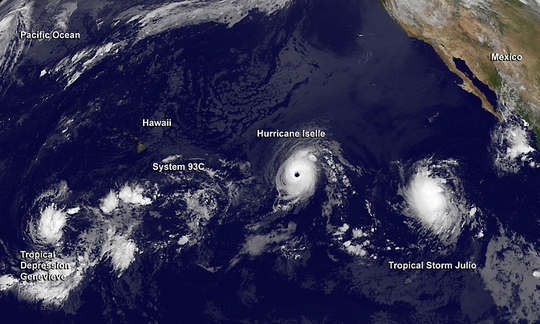 Behind System 93C to the east, lies Hurricane Iselle, the current powerhouse of the Eastern Pacific.
The Moderate Resolution Imaging Spectroradiometer or MODIS instrument that flies aboard NASA's Aqua satellite captured a clear visible image of Hurricane Iselle in the eastern Pacific Ocean on August 3 at 6:05 p.m. EDT. The image revealed Iselle's somewhat cloud-covered eye with bands of thunderstorms wrapping into the center from the eastern quadrant. The image was created by The MODIS Rapid Response Team at NASA's Goddard Space Flight Center in Greenbelt, Maryland.
On August 4 at 1500 UTC (11 a.m. EDT) Hurricane Iselle's maximum sustained winds had increased to near 140 mph (220 kph) Iselle is a category four hurricane on the Saffir-Simpson hurricane wind scale. The eye of Hurricane Iselle was located near latitude 16.2 north and longitude 136.5 west. Iselle was moving toward the west near 10 mph (17 kph). The National Hurricane Center noted that gradual weakening is forecast during the next couple of days. The estimated minimum central pressure is 947 millibars.
The current forecast track from the National Hurricane Center takes a weaker Iselle through the entire chain of Hawaiian Islands from August 7 through August 9.
Behind System 93C to the east, lies Hurricane Iselle, the current powerhouse of the Eastern Pacific.
The Moderate Resolution Imaging Spectroradiometer or MODIS instrument that flies aboard NASA's Aqua satellite captured a clear visible image of Hurricane Iselle in the eastern Pacific Ocean on August 3 at 6:05 p.m. EDT. The image revealed Iselle's somewhat cloud-covered eye with bands of thunderstorms wrapping into the center from the eastern quadrant. The image was created by The MODIS Rapid Response Team at NASA's Goddard Space Flight Center in Greenbelt, Maryland.
On August 4 at 1500 UTC (11 a.m. EDT) Hurricane Iselle's maximum sustained winds had increased to near 140 mph (220 kph) Iselle is a category four hurricane on the Saffir-Simpson hurricane wind scale. The eye of Hurricane Iselle was located near latitude 16.2 north and longitude 136.5 west. Iselle was moving toward the west near 10 mph (17 kph). The National Hurricane Center noted that gradual weakening is forecast during the next couple of days. The estimated minimum central pressure is 947 millibars.
The current forecast track from the National Hurricane Center takes a weaker Iselle through the entire chain of Hawaiian Islands from August 7 through August 9.
Newborn Tropical Storm Julio Chasing Iselle
Tropical Storm Julio was born around 11 p.m. EDT on Sunday, August 3, about 795 miles (1,280 km) southwest of the southern tip of Baja California, Mexico. On August 4 at 1500 UTC (11 a.m. EDT), Julio's maximum sustained winds were near 45 mph (75 kph). The center of Tropical Storm Julio was near latitude 13.5 north and longitude 119.4 west. Julio is moving toward the west near 13 mph (20 kph) and is expected to continue in a west to west-northwestward direction over the next couple of days. The estimated minimum central pressure is 1004 millibars. Strong northeasterly vertical wind shear is pushing the strongest thunderstorms in Julio to the western side of the storm. The National Hurricane Center noted that the wind shear is expected to continue to August 5 or 6, which will limit any intensification. NHC expects Julio to become a hurricane later this week. Satellites from NASA and NOAA continue to provide visible, infrared, microwave data to forecasters. Beginning in August, NASA's Hurricane Severe Storms Sentinel or HS3 mission takes to the Atlantic using two unmanned Global Hawk aircraft to study the storms. For more information about NASA's HS3 mission, visit: www.nasa.gov/HS3. Tropical Storm Iselle was born in the Eastern Pacific Ocean soon after NASA's Aqua satellite gathered infrared imagery on the storm that showed powerful thunderstorms wrapping into developing storm's center. Iselle is not close enough to land to cause any watches or warnings. The Atmospheric Infrared Sounder or AIRS instrument aboard NASA's Aqua satellite passed over System 95E on July 31 at 5:23 p.m. EDT from gathered infrared data before it became Tropical Storm Iselle. The data was made into a false-colored image at NASA's Jet Propulsion Laboratory in Pasadena, California. The AIRS data showed a large band of powerful thunderstorms west of Iselle's center wrapping into the storm. The thunderstorms had cloud top temperatures as cold as -63F/-52C indicating the cloud tops were near the top of the troposphere. National Hurricane Center forecaster Blake noted in an August 1 discussion "A recent AMSU microwave pass also suggests that the inner core has become better defined, with perhaps a partial eyewall in the eastern semicircle." Advanced microwave sounding unit (AMSU) is a multi-channel microwave radiometer installed on meteorological satellites, including NASA's Aqua satellite that carries the AIRS instrument. Tropical storm Iselle was born on July 31 at 2100 UTC (5 p.m. EDT). On August 1, Iselle's maximum sustained winds were already up to 60 mph (95 kph). At 5 a.m. EDT (2 a.m. PDT/0900 UTC).the center of Tropical Storm Iselle was located near latitude 13.5 north and longitude 124.6 west. Iselle is centered about 1,160 miles (1,870 km) west-southwest of the southern tip of Baja California, Mexico. Iselle was moving toward the west-northwest near 10 mph (17 kph) and is expected to continue moving in that direction over the next couple of days. Satellite data indicate that tropical storm force winds extend outward up to 105 miles (165 km) from the center, making the storm about 210 miles in diameter. NHC noted that environmental conditions appear conducive for further strengthening over the next couple of days. Those conditions include light-to-moderate northeasterly shear and warm water.
Archiv
29_201429_2014
29_2014
28_2014
27_2014
26_2014
26_2014
25_2014
24_2014
23_2014
22_2014
21_2014
20_2014
20_2014
20_2014
19_2014
18_2014
17_2014
16_2014
15_2014
14_2014
54_2013
53_2013
52_2013
51_2013
50_2013
49_2013
48_2013
47_2013
46_2013
45_2013
44_2013
43_2013
42_2013
41_2013
40_2013
39_2013
38_2013
37_2013
36_2013
35_2013
34_2013
33_2013
32_2013
31_2013
30_2013
29_2013
28_2013
27_2013
26_2013
25_2013
24_2013
23_2013
22_2013
21_2013
20_2013
19_2013
18_2013
17_2013
16_2013
15_2013
14_2013
13_2013
12_2013
11_2013
10_2013
09_2013
08_2013
07_2013
06_2013
05_2013
04_2013
03_2013
02_2013
01_2013

 | Zemědělská 1/1665 613 00 Brno Budova D | Tel.: +420 545 133 350 Fax.: +420 545 212 044 |  |
 |