

Každý, kdo se přestane učit, je starý, ať je mu 20 nebo 80. Každý, kdo se stále učí, zůstává mladý. Je nejlepší v životě zůstat mladý.
Henry Ford
Konference
Konference v roce 2015
Konference v roce 2014
Konference v roce 2013
Konference v roce 2012
Konference v roce 2011


Polní laboratoř
Tropical Cyclone Hellen Makes Landfall in Madagascar
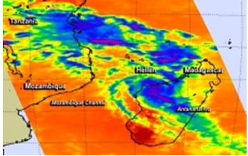 Tropical Cyclone Hellen made landfall in west central Madagascar as NASA's Aqua satellite passed overhead capturing temperature data on its towering thunderstorms.
When NASA's Aqua satellite passed over Madagascar on March 31 at 10:47 UTC/6:47 a.m. EDT and the Atmospheric Infrared Sounder or AIRS instrument aboard captured infrared data on Hellen. AIRS data showed powerful thunderstorms circling the center of circulation with cloud top temperatures in excess of -63F/-52C indicating they were high into the troposphere. Thunderstorms reaching those heights also have the potential for heavy rainfall.
Hellen developed during the week of March 23 in the Mozambique Channel, the body of water that lies between the island nation of Madagascar and Mozambique on the African mainland. By March 26, at 20:00 UTC/4 p.m. EDT, the tropical low, then known as System 95S was centered near 10.7 south latitude and 39.4 east longitude. The low level center was actually over land just inland from the coast, and sitting over the Tanzania and Mozambique border. It was on March 26, that the Joint Typhoon Warning Center or JTWC noted that the low had a high chance for becoming a tropical depression in the next 24 hours. JTWC noted that enhanced infrared satellite imagery on March 26 revealed that the low-level circulation center has consolidated and there were bands of thunderstorms wrapping into it. JTWC estimated that maximum sustained winds are between 25 to 30 knots/ 28.7 to 34.5 mph/46.3 to 55.5 kph.
At that time, the tropical low was in an area that had low vertical wind shear and warm sea surface temperatures that forecasters at JTWC said would provide the fuel for thunderstorms to develop and assist the low's growth. Over the next several days, System 95S moved east and back into the Mozambique Channel where it rapidly intensified into Tropical Cyclone Hellen and reached Category IV status on the Saffir-Simpson Scale when maximum sustained winds peaked near 140 knots/161.1 mph/259.3 kph. By March 31 at 1500 UTC/11 a.m. EDT, Hellen's maximum sustained winds dropped to 85 knots/97.8 mph/ 157.4 kph because of the interaction with Madagascar. It was centered near 16.2 south latitude and 45.9 east longitude, about 180 nautical miles/207.1 miles/333.4 km north-northwest of Antananarivo, Madagascar. The NOAA-19 satellite showed that the bulk of strongest thunderstorms were south of the center as a result of wind shear. In addition there is dry air moving into the center of circulation which is also helping to weaken Hellen.
Hellen was moving slowly to the south-southeast at 5 knots/5.7 mph/9.2 kph, and the JWTC expects it to curve to the southwest and re-enter the Mozambique Channel.
Tropical Cyclone Hellen made landfall in west central Madagascar as NASA's Aqua satellite passed overhead capturing temperature data on its towering thunderstorms.
When NASA's Aqua satellite passed over Madagascar on March 31 at 10:47 UTC/6:47 a.m. EDT and the Atmospheric Infrared Sounder or AIRS instrument aboard captured infrared data on Hellen. AIRS data showed powerful thunderstorms circling the center of circulation with cloud top temperatures in excess of -63F/-52C indicating they were high into the troposphere. Thunderstorms reaching those heights also have the potential for heavy rainfall.
Hellen developed during the week of March 23 in the Mozambique Channel, the body of water that lies between the island nation of Madagascar and Mozambique on the African mainland. By March 26, at 20:00 UTC/4 p.m. EDT, the tropical low, then known as System 95S was centered near 10.7 south latitude and 39.4 east longitude. The low level center was actually over land just inland from the coast, and sitting over the Tanzania and Mozambique border. It was on March 26, that the Joint Typhoon Warning Center or JTWC noted that the low had a high chance for becoming a tropical depression in the next 24 hours. JTWC noted that enhanced infrared satellite imagery on March 26 revealed that the low-level circulation center has consolidated and there were bands of thunderstorms wrapping into it. JTWC estimated that maximum sustained winds are between 25 to 30 knots/ 28.7 to 34.5 mph/46.3 to 55.5 kph.
At that time, the tropical low was in an area that had low vertical wind shear and warm sea surface temperatures that forecasters at JTWC said would provide the fuel for thunderstorms to develop and assist the low's growth. Over the next several days, System 95S moved east and back into the Mozambique Channel where it rapidly intensified into Tropical Cyclone Hellen and reached Category IV status on the Saffir-Simpson Scale when maximum sustained winds peaked near 140 knots/161.1 mph/259.3 kph. By March 31 at 1500 UTC/11 a.m. EDT, Hellen's maximum sustained winds dropped to 85 knots/97.8 mph/ 157.4 kph because of the interaction with Madagascar. It was centered near 16.2 south latitude and 45.9 east longitude, about 180 nautical miles/207.1 miles/333.4 km north-northwest of Antananarivo, Madagascar. The NOAA-19 satellite showed that the bulk of strongest thunderstorms were south of the center as a result of wind shear. In addition there is dry air moving into the center of circulation which is also helping to weaken Hellen.
Hellen was moving slowly to the south-southeast at 5 knots/5.7 mph/9.2 kph, and the JWTC expects it to curve to the southwest and re-enter the Mozambique Channel.
Three Atmospheric 'Dragons': Low Pressure Areas Around the U.S.
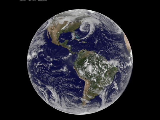 There are three low pressure systems around the U.S. and they resemble dragons on satellite imagery. NOAA's GOES-13 and GOES-15 satellite image from March 31, 2014 shows the low pressure systems in the eastern Pacific Ocean, over the nation's Heartland, and in the eastern Atlantic Ocean. All three lows have the signature comma shape that make them appear to be curled up dragons.
According to the National Weather Service, the low pressure area approaching the northwestern U.S. is expected to bring rainfall to the coast and areas of snow that stretch from western Washington state south toward the four corners region. The low in the middle of the country is located over Nebraska and dropping snow to the north and west of it. That same low is bringing rain from southern Minnesota south to eastern Texas. Meanwhile, the third low pressure system is bringing rain and snow to parts of New England.
NOAA's GOES-East satellite sits in a fixed orbit in space capturing visible and infrared imagery of all weather over the eastern U.S. and Atlantic Ocean.
The data to create this image was taken on March 31, 2014 at 17:45 UTC/1:45 p.m. EDT by NOAA's GOES-East or GOES-13 satellite and made into an image by NASA/NOAA's GOES Project at NASA's Goddard Space Flight Center in Greenbelt, Md.
There are three low pressure systems around the U.S. and they resemble dragons on satellite imagery. NOAA's GOES-13 and GOES-15 satellite image from March 31, 2014 shows the low pressure systems in the eastern Pacific Ocean, over the nation's Heartland, and in the eastern Atlantic Ocean. All three lows have the signature comma shape that make them appear to be curled up dragons.
According to the National Weather Service, the low pressure area approaching the northwestern U.S. is expected to bring rainfall to the coast and areas of snow that stretch from western Washington state south toward the four corners region. The low in the middle of the country is located over Nebraska and dropping snow to the north and west of it. That same low is bringing rain from southern Minnesota south to eastern Texas. Meanwhile, the third low pressure system is bringing rain and snow to parts of New England.
NOAA's GOES-East satellite sits in a fixed orbit in space capturing visible and infrared imagery of all weather over the eastern U.S. and Atlantic Ocean.
The data to create this image was taken on March 31, 2014 at 17:45 UTC/1:45 p.m. EDT by NOAA's GOES-East or GOES-13 satellite and made into an image by NASA/NOAA's GOES Project at NASA's Goddard Space Flight Center in Greenbelt, Md.
NASA's Aqua Satellite Flies Over Newborn Tropical Depression 05W
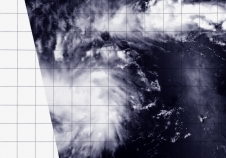 The fifth tropical depression of the northwestern Pacific Ocean tropical cyclone season formed far from land as NASA's Aqua satellite passed overhead and captured a visible image of the storm on April 4.
NASA's Aqua satellite passed over newborn Tropical Depression 05W on April 3 at 03:10 UTC/April 2 at 11:10 p.m. EDT. The Moderate Resolution Imaging Spectroradiometer or MODIS instrument captured a visible picture of the storm, revealing good circulation and strong convection and thunderstorms around the center of circulation.
The Joint Typhoon Warning Center or JTWC noted that animated multispectral satellite imagery today, April 3, showed that the low-level circulation center has been consolidating and that there is fragmented convective banding of thunderstorms around the center.
At 0900 UTC/5 a.m. EDT on April 3, Tropical Depression 05W (05W) had maximum sustained winds near 25 knots/28.7 mph/46.3 kph. It was located near 1.8 north latitude and 146.3 east longitude, about 784 nautical miles/902.2 miles/1,452 km east-southeast of Koror. According to Wikipedia, Koror Island is the most populated island in the Republic of Palau.
The depression is moving to the west at 9 knots/10.3 mph/16.6 kph and according to the Joint Typhoon Warning Center, is expected to move through southern Micronesia on its way toward the Philippines. JTWC forecasters noted that 05W is forecast to track through waters with high ocean heat content, so the storm is expected to strengthen to typhoon strength by April 7.
Tropical Depression 05W was formerly known as System 95W
The fifth tropical depression of the northwestern Pacific Ocean tropical cyclone season formed far from land as NASA's Aqua satellite passed overhead and captured a visible image of the storm on April 4.
NASA's Aqua satellite passed over newborn Tropical Depression 05W on April 3 at 03:10 UTC/April 2 at 11:10 p.m. EDT. The Moderate Resolution Imaging Spectroradiometer or MODIS instrument captured a visible picture of the storm, revealing good circulation and strong convection and thunderstorms around the center of circulation.
The Joint Typhoon Warning Center or JTWC noted that animated multispectral satellite imagery today, April 3, showed that the low-level circulation center has been consolidating and that there is fragmented convective banding of thunderstorms around the center.
At 0900 UTC/5 a.m. EDT on April 3, Tropical Depression 05W (05W) had maximum sustained winds near 25 knots/28.7 mph/46.3 kph. It was located near 1.8 north latitude and 146.3 east longitude, about 784 nautical miles/902.2 miles/1,452 km east-southeast of Koror. According to Wikipedia, Koror Island is the most populated island in the Republic of Palau.
The depression is moving to the west at 9 knots/10.3 mph/16.6 kph and according to the Joint Typhoon Warning Center, is expected to move through southern Micronesia on its way toward the Philippines. JTWC forecasters noted that 05W is forecast to track through waters with high ocean heat content, so the storm is expected to strengthen to typhoon strength by April 7.
Tropical Depression 05W was formerly known as System 95W
NASA Sees Tropical Storm 22S Come Together
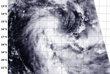 Tropical Storm 22S came together on April 4 during the afternoon hours (Eastern Daylight Time/U.S.) in the Southern Indian Ocean as NASA's Aqua satellite passed overhead.
The Moderate Resolution Imaging Spectroradiometer instrument aboard Aqua provided a visible look at the tropical low pressure area formerly identified as System 96S. The MODIS image showed a large band of thunderstorms from the southern quadrant sweeping around the western side of circulation into the center from the north.
At 1500 UTC/11 a.m. EDT on April 4, Tropical Storm 22S had maximum sustained winds near 35 knots/40 mph/62 kph. It was centered about 699 nautical miles southeast of Diego Garcia, near 16.6 south and 79.4 east. 22S was moving to the south at 11 knots. The Joint Typhoon Warning Center expects 22S to intensify slightly as it moves south over the next three days, by which time it is expected to have become extra-tropical.
Tropical Storm 22S came together on April 4 during the afternoon hours (Eastern Daylight Time/U.S.) in the Southern Indian Ocean as NASA's Aqua satellite passed overhead.
The Moderate Resolution Imaging Spectroradiometer instrument aboard Aqua provided a visible look at the tropical low pressure area formerly identified as System 96S. The MODIS image showed a large band of thunderstorms from the southern quadrant sweeping around the western side of circulation into the center from the north.
At 1500 UTC/11 a.m. EDT on April 4, Tropical Storm 22S had maximum sustained winds near 35 knots/40 mph/62 kph. It was centered about 699 nautical miles southeast of Diego Garcia, near 16.6 south and 79.4 east. 22S was moving to the south at 11 knots. The Joint Typhoon Warning Center expects 22S to intensify slightly as it moves south over the next three days, by which time it is expected to have become extra-tropical.
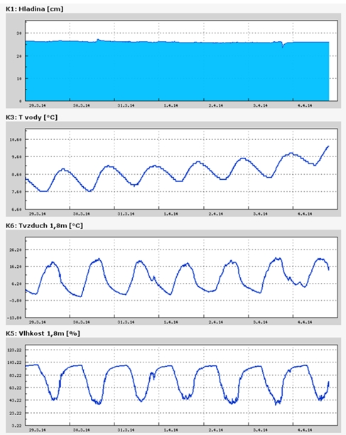
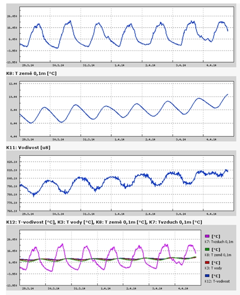
Teplota vzduchu a vody, vlhkost ,
 https://stanice.fiedler-magr.cz
Archiv
14_201454_2013
53_2013
52_2013
51_2013
50_2013
49_2013
48_2013
47_2013
46_2013
45_2013
44_2013
43_2013
42_2013
41_2013
40_2013
39_2013
38_2013
37_2013
36_2013
35_2013
34_2013
33_2013
32_2013
31_2013
30_2013
29_2013
28_2013
27_2013
26_2013
25_2013
24_2013
23_2013
22_2013
21_2013
20_2013
19_2013
18_2013
17_2013
16_2013
15_2013
14_2013
13_2013
12_2013
11_2013
10_2013
09_2013
08_2013
07_2013
06_2013
05_2013
04_2013
03_2013
02_2013
01_2013

 | Zemědělská 1/1665 613 00 Brno Budova D | Tel.: +420 545 133 350 Fax.: +420 545 212 044 |  |
 |