

Účelem vzdělání není zaplnit mysl, ale otevřít ji. Čím více poznatků si osvojíme, tím víc si uvědomíme, co ještě neznáme.
Konference
Konference v roce 2015
Konference v roce 2014
Konference v roce 2013
Konference v roce 2012
Konference v roce 2011


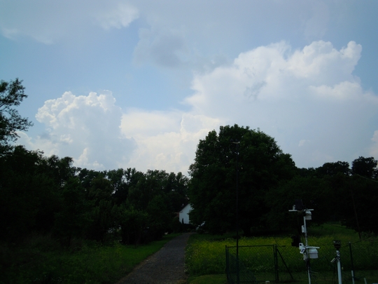
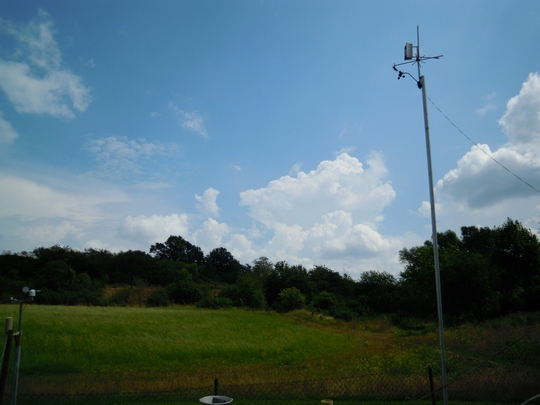
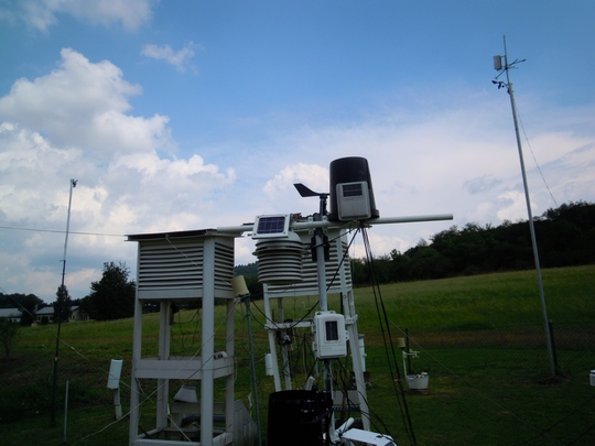
Polní laboratoř
Gil (Eastern Pacific)
 Tropical Depression Gil regained strength after moving into warmer waters and an area with lighter wind shear as Hurricane Henriette hangs on. NASA's Aqua satellite captured an infrared look at both storms showing powerful thunderstorms around each of their centers of circulation.
The Atmospheric Infrared Sounder or AIRS instrument aboard NASA's Aqua satellite captured infrared data on both Gil and Henriette on Aug. 6 at 10:39 UTC (6:39 a.m. EDT). At that time both Tropical Storm Gil and Hurricane Henriette had large areas of strong thunderstorms with very cold cloud tops around their centers. The cloud top temperatures in both storms were colder than -63F/-52C, which indicates thunderstorms high into the troposphere. Thunderstorms that high are also indicative of moderate to heavy rainfall. Gil Regains Strength
Tropical Depression Gil regained strength after moving into warmer waters and an area with lighter wind shear as Hurricane Henriette hangs on. NASA's Aqua satellite captured an infrared look at both storms showing powerful thunderstorms around each of their centers of circulation.
The Atmospheric Infrared Sounder or AIRS instrument aboard NASA's Aqua satellite captured infrared data on both Gil and Henriette on Aug. 6 at 10:39 UTC (6:39 a.m. EDT). At that time both Tropical Storm Gil and Hurricane Henriette had large areas of strong thunderstorms with very cold cloud tops around their centers. The cloud top temperatures in both storms were colder than -63F/-52C, which indicates thunderstorms high into the troposphere. Thunderstorms that high are also indicative of moderate to heavy rainfall. Gil Regains Strength
Tropical Depression Gil regained tropical storm status today as maximum sustained winds increased to near 40 mph/65 kph. The Central Pacific Hurricane Center or CPHC is now issuing advisories on Gil because it moved into their forecast territory. CPHC forecasters expect Gil will gradually strengthen during the next 48 hours. At 0900 UTC/5 a.m. EDT on Aug. 6, or 11 p.m. HST local Hawaii time on Aug. 5, the center of Tropical Storm Gil was located near latitude 13.3 north and longitude 141.0 west. That's about 1,035 miles/1,660 km east-southeast of Hilo, Hawaii. Gil is moving toward the west near 9 mph/15 kph and this motion is expected to continue over the next two days. Gil is forecast to move west and move far south of the Hawaiian Islands over the weekend of Aug. 10 and 11. Satellite data shows that deep convection (rising air that forms the thunderstorms that make up the tropical storm) has spread back over Gil's low level center. Previously, when Gil was a depression, the center became partly exposed to outside winds and that's no longer the case. Gil is moving over waters warm enough to support its strength. Infrared data from NASA's Atmospheric Infrared Sounder or AIRS instrument revealed that the water temperatures around Gil are over 80F/26.6C. Gil is also moving into an area of lighter wind shear, which will also allow the storm to keep together and even strengthen.
NASA Eyes Two Eastern Pacific Tropical Cyclones: One Up, One Down
 Tropical Depression Gil has been weakening for a couple of days, while Tropical Storm Henriette appears to be strengthening in the Eastern Pacific Ocean. NOAA's GOES-15 satellite captured both storms in one image that clearly showed Henriette was the larger storm, and NASA's Aqua satellite peered under Henriette's clouds to reveal a developing eye.
Tropical Depression Gil is more than halfway to Hawaii from Mexico and continues to hold onto depression strength. Meanwhile, NOAA's GOES-15 satellite captured both storms in one image on Aug. 5 at 1200 UTC (8 a.m. EDT). The imagery shows Tropical Storm Henriette dwarfed the smaller Gil. The infrared image was created by NASA's GOES Project at NASA's Goddard Space Flight Center in Greenbelt, Md. GOES satellite imagery showed a circular concentration of thunderstorms tightly around Gil's small center, while Henriette, located to the east, is several times the size of Gil. Gil is Tropically "Depressed"
On Monday, Aug. 4 at 11 a.m. EDT (1500 UTC) the center of Tropical Storm Gil was near latitude 13.4 north and longitude 138.6 west, about 1,175 miles/1,890 km east-southeast of Hilo, Hawaii. Gil is moving toward the west-southwest near 8 mph (13 kph) and is expected to continue in that direction for the next day and turn west. Gil's maximum sustained winds were near 30 mph (45 kph). Gil became a depression over the weekend of Aug. 3 and 4 after reaching hurricane status. Gradual weakening is forecast during the next 48 hours. The estimated minimum central pressure is 1007 millibars.
The National Hurricane Center noted that Gil is weakening and will likely cease to qualify as a tropical cyclone in the next day or two. However, if Gil survives the adverse atmospheric environment and holds together, it would track far south of the Hawaiian Island chain over the weekend of Aug. 10 and 11.
NASA Infrared Data Shows a Developing Eye in Henriette
Infrared data from the Atmospheric Infrared Sounder or AIRS instrument that flies aboard NASA's Aqua satellite showed a developing eye in Tropical Storm Henriette. AIRS captured an infrared image of Tropical Storm Henriette on August 5 at 0917 UTC (5:17 a.m. EDT). Strongest storms and heaviest rains appeared around the center where cloud top temperatures exceeded -63F/-52C. The GOES satellite imagery showed that Henriette had grown in size and dwarfs Tropical Depression Gil, located to its west.
Henriette developed from the System 90E which became the eighth tropical depression of the eastern Pacific Ocean hurricane season over the weekend of Aug. 3 and 4.
On Aug. 5 at 11 a.m. EDT (1500 UTC), Tropical Storm Henriette's maximum sustained winds had increased to near 60 mph/95 kph. Further strengthening is forecast by the National Hurricane Center and Henriette is expected to become a hurricane in the next day.
Henriette was located near latitude 12.1 north and longitude 128.2 west, about 1,415 miles (2,280 km west-southwest of the southern tip of Baja California, Mexico. Henriette is moving toward the west near 6 mph/9 kph and is expected to turn west-northwestward Minimum central pressure is near 999 millibars
Tropical Depression Gil has been weakening for a couple of days, while Tropical Storm Henriette appears to be strengthening in the Eastern Pacific Ocean. NOAA's GOES-15 satellite captured both storms in one image that clearly showed Henriette was the larger storm, and NASA's Aqua satellite peered under Henriette's clouds to reveal a developing eye.
Tropical Depression Gil is more than halfway to Hawaii from Mexico and continues to hold onto depression strength. Meanwhile, NOAA's GOES-15 satellite captured both storms in one image on Aug. 5 at 1200 UTC (8 a.m. EDT). The imagery shows Tropical Storm Henriette dwarfed the smaller Gil. The infrared image was created by NASA's GOES Project at NASA's Goddard Space Flight Center in Greenbelt, Md. GOES satellite imagery showed a circular concentration of thunderstorms tightly around Gil's small center, while Henriette, located to the east, is several times the size of Gil. Gil is Tropically "Depressed"
On Monday, Aug. 4 at 11 a.m. EDT (1500 UTC) the center of Tropical Storm Gil was near latitude 13.4 north and longitude 138.6 west, about 1,175 miles/1,890 km east-southeast of Hilo, Hawaii. Gil is moving toward the west-southwest near 8 mph (13 kph) and is expected to continue in that direction for the next day and turn west. Gil's maximum sustained winds were near 30 mph (45 kph). Gil became a depression over the weekend of Aug. 3 and 4 after reaching hurricane status. Gradual weakening is forecast during the next 48 hours. The estimated minimum central pressure is 1007 millibars.
The National Hurricane Center noted that Gil is weakening and will likely cease to qualify as a tropical cyclone in the next day or two. However, if Gil survives the adverse atmospheric environment and holds together, it would track far south of the Hawaiian Island chain over the weekend of Aug. 10 and 11.
NASA Infrared Data Shows a Developing Eye in Henriette
Infrared data from the Atmospheric Infrared Sounder or AIRS instrument that flies aboard NASA's Aqua satellite showed a developing eye in Tropical Storm Henriette. AIRS captured an infrared image of Tropical Storm Henriette on August 5 at 0917 UTC (5:17 a.m. EDT). Strongest storms and heaviest rains appeared around the center where cloud top temperatures exceeded -63F/-52C. The GOES satellite imagery showed that Henriette had grown in size and dwarfs Tropical Depression Gil, located to its west.
Henriette developed from the System 90E which became the eighth tropical depression of the eastern Pacific Ocean hurricane season over the weekend of Aug. 3 and 4.
On Aug. 5 at 11 a.m. EDT (1500 UTC), Tropical Storm Henriette's maximum sustained winds had increased to near 60 mph/95 kph. Further strengthening is forecast by the National Hurricane Center and Henriette is expected to become a hurricane in the next day.
Henriette was located near latitude 12.1 north and longitude 128.2 west, about 1,415 miles (2,280 km west-southwest of the southern tip of Baja California, Mexico. Henriette is moving toward the west near 6 mph/9 kph and is expected to turn west-northwestward Minimum central pressure is near 999 millibars
NASA Sees Henriette Still a Hurricane
 Tropical Depression Gil regained strength after moving into warmer waters and an area with lighter wind shear as Hurricane Henriette hangs on. NASA's Aqua satellite captured an infrared look at both storms showing powerful thunderstorms around each of their centers of circulation.
The Atmospheric Infrared Sounder or AIRS instrument aboard NASA's Aqua satellite captured infrared data on both Gil and Henriette on Aug. 6 at 10:39 UTC (6:39 a.m. EDT). At that time both Tropical Storm Gil and Hurricane Henriette had large areas of strong thunderstorms with very cold cloud tops around their centers. The cloud top temperatures in both storms were colder than -63F/-52C, which indicates thunderstorms high into the troposphere. Thunderstorms that high are also indicative of moderate to heavy rainfall. Henriette the Hurricane
On Aug. 6 at 1500 UTC/11 a.m. EDT, Hurricane Henriette had maximum sustained winds near 80 mph/130 kph. Forecasters at the National Hurricane Center expect additional strengthening as Henriette continues to trail Tropical Storm Gil on a westward trek.
Henriette was centered about 1,605 miles/2,580 km east of Hilo, Hawaii, near 14.2 north latitude and 131.5 west longitude. Henriette was moving to the northwest near 10 mph/17 kph and is expected to fluctuate between a west-northwest and northwesterly direction over the next several days. The estimated minimum central pressure is 986 millibars. In two days, the Henriette is expected to move into slightly cooler waters and a drier, more stable airmass which is expected to weaken the storm.
In microwave satellite imagery today, Aug. 6, data revealed a well-defined eye in Henriette. In fact, the eye has even been spotted on GOES-15 visible imagery.
Tropical Depression Gil regained strength after moving into warmer waters and an area with lighter wind shear as Hurricane Henriette hangs on. NASA's Aqua satellite captured an infrared look at both storms showing powerful thunderstorms around each of their centers of circulation.
The Atmospheric Infrared Sounder or AIRS instrument aboard NASA's Aqua satellite captured infrared data on both Gil and Henriette on Aug. 6 at 10:39 UTC (6:39 a.m. EDT). At that time both Tropical Storm Gil and Hurricane Henriette had large areas of strong thunderstorms with very cold cloud tops around their centers. The cloud top temperatures in both storms were colder than -63F/-52C, which indicates thunderstorms high into the troposphere. Thunderstorms that high are also indicative of moderate to heavy rainfall. Henriette the Hurricane
On Aug. 6 at 1500 UTC/11 a.m. EDT, Hurricane Henriette had maximum sustained winds near 80 mph/130 kph. Forecasters at the National Hurricane Center expect additional strengthening as Henriette continues to trail Tropical Storm Gil on a westward trek.
Henriette was centered about 1,605 miles/2,580 km east of Hilo, Hawaii, near 14.2 north latitude and 131.5 west longitude. Henriette was moving to the northwest near 10 mph/17 kph and is expected to fluctuate between a west-northwest and northwesterly direction over the next several days. The estimated minimum central pressure is 986 millibars. In two days, the Henriette is expected to move into slightly cooler waters and a drier, more stable airmass which is expected to weaken the storm.
In microwave satellite imagery today, Aug. 6, data revealed a well-defined eye in Henriette. In fact, the eye has even been spotted on GOES-15 visible imagery.
Mangkhut (Northwest Pacific Ocean)
 Tropical Depression 10W has strengthened in 24 hours and become Tropical Storm Mangkhut. Infrared imagery from NASA's Aqua satellite revealed the strong thunderstorms around Mangkhut's center that hinted at that intensification.
Forecasters at the Joint Typhoon Warning Center or JTWC expect Mangkhut to make landfall in northern Vietnam sometime on Aug. 8, just days after Tropical Storm Jebi made landfall and took lives. JTWC takes Mangkhut from the southeast, through the Gulf of Tonkin and making landfall just south of Hanoi. Tropical Storm Jebi came from the east, over Hainan Island, China and made landfall north of Hanoi.
At 1500 UTC (11 a.m. EDT) on Aug. 6, Tropical Storm Mangkhut had maximum sustained winds near 35 knots/40.2 mph/64.8 kph. The center of Mangkhut was located near 16.4 north and 109.7 east, about 104 nautical miles/ 119.7 miles/192.6 km east of Da Nang, Vietnam. Mangkhut is moving to the northwest at 17 knots/19.5 mph/31.4 kph.
Infrared satellite imagery from the Atmospheric Infrared Sounder or AIRS instrument aboard NASA's Aqua satellite taken on Aug. 5 at 17:59 UTC (12:59 p.m. EDT) showed strong thunderstorms with very cold cloud tops around the center of what was Tropical Depression 10W. The depression since strengthened into a tropical storm. AIRS also revealed fragmented bands of thunderstorms wrapping into the low-level center of the storm.
The JTWC is forecasting Tropical Storm Mangkhut to drift across the Gulf of Tonkin, and make landfall just southeast of Hanoi.
Tropical Depression 10W has strengthened in 24 hours and become Tropical Storm Mangkhut. Infrared imagery from NASA's Aqua satellite revealed the strong thunderstorms around Mangkhut's center that hinted at that intensification.
Forecasters at the Joint Typhoon Warning Center or JTWC expect Mangkhut to make landfall in northern Vietnam sometime on Aug. 8, just days after Tropical Storm Jebi made landfall and took lives. JTWC takes Mangkhut from the southeast, through the Gulf of Tonkin and making landfall just south of Hanoi. Tropical Storm Jebi came from the east, over Hainan Island, China and made landfall north of Hanoi.
At 1500 UTC (11 a.m. EDT) on Aug. 6, Tropical Storm Mangkhut had maximum sustained winds near 35 knots/40.2 mph/64.8 kph. The center of Mangkhut was located near 16.4 north and 109.7 east, about 104 nautical miles/ 119.7 miles/192.6 km east of Da Nang, Vietnam. Mangkhut is moving to the northwest at 17 knots/19.5 mph/31.4 kph.
Infrared satellite imagery from the Atmospheric Infrared Sounder or AIRS instrument aboard NASA's Aqua satellite taken on Aug. 5 at 17:59 UTC (12:59 p.m. EDT) showed strong thunderstorms with very cold cloud tops around the center of what was Tropical Depression 10W. The depression since strengthened into a tropical storm. AIRS also revealed fragmented bands of thunderstorms wrapping into the low-level center of the storm.
The JTWC is forecasting Tropical Storm Mangkhut to drift across the Gulf of Tonkin, and make landfall just southeast of Hanoi.
NASA Sees Some Strength in Developing Tropical Depression 11W Headed for Luzon
 This infrared image from NASA’s Aqua satellite on Aug. 8 showed some cloud top temperatures in bands of thunderstorms and around the center of Tropical Depression 11W are as cold as -63F/-52C (purple) indicating strong storms.
Tropical Depression 11W formed in the western North Pacific Ocean and appears to be tracking toward Luzon, in the Northern Philippines. NASA's Aqua satellite captured an infrared image of the tropical depression as it continues to organize and strengthen.
On Aug. 8 at 1853 UTC (2:53 p.m. EDT) NASA's Atmospheric Infrared Sounder or AIRS instrument that flies aboard NASA’s Aqua satellite showed some cloud top temperatures in bands of thunderstorms and around the center of Tropical Depression 11W were as cold as -63F/-52C, indicating strong storms.
What does Infrared Data Show?
AIRS infrared images are false-colored to show temperature differences. Scientists look at cloud top temperatures to understand how high the thunderstorms are that make up a tropical cyclone - and there are hundreds of thunderstorms that make up one storm. The colder the cloud top temperature, the higher the top of the thunderstorm reaches into the troposphere and the stronger the storm. NASA research has indicated that cloud top temperatures that reach or exceed the threshold of -63F/-52C typically have heavy rainfall rates.
On Aug. 9 at 1200 UTC (8 a.m. EDT), Tropical Depression 11W's maximum sustained winds near 30 knots/34.5 mph/55.5 kph. 11W's center was located about 671 nautical miles/ 772.2 miles/1,243 km east of Manila, Philippines, near 14.0 north and 132.0 east. 11W is moving west at 10 knots/11.5 mph/18.5 kph. When 11W strengthens into a tropical storm, it will be renamed Tropical Storm Utor.
Forecasters at the Joint Typhoon Warning Center have forecast Tropical Depression 11W's path. After crossing Luzon on Aug. 11 as a tropical storm, 11W is expected to become a typhoon as it moves through the South China Sea on Aug. 12 and 13 before making a landfall in southern China.
This infrared image from NASA’s Aqua satellite on Aug. 8 showed some cloud top temperatures in bands of thunderstorms and around the center of Tropical Depression 11W are as cold as -63F/-52C (purple) indicating strong storms.
Tropical Depression 11W formed in the western North Pacific Ocean and appears to be tracking toward Luzon, in the Northern Philippines. NASA's Aqua satellite captured an infrared image of the tropical depression as it continues to organize and strengthen.
On Aug. 8 at 1853 UTC (2:53 p.m. EDT) NASA's Atmospheric Infrared Sounder or AIRS instrument that flies aboard NASA’s Aqua satellite showed some cloud top temperatures in bands of thunderstorms and around the center of Tropical Depression 11W were as cold as -63F/-52C, indicating strong storms.
What does Infrared Data Show?
AIRS infrared images are false-colored to show temperature differences. Scientists look at cloud top temperatures to understand how high the thunderstorms are that make up a tropical cyclone - and there are hundreds of thunderstorms that make up one storm. The colder the cloud top temperature, the higher the top of the thunderstorm reaches into the troposphere and the stronger the storm. NASA research has indicated that cloud top temperatures that reach or exceed the threshold of -63F/-52C typically have heavy rainfall rates.
On Aug. 9 at 1200 UTC (8 a.m. EDT), Tropical Depression 11W's maximum sustained winds near 30 knots/34.5 mph/55.5 kph. 11W's center was located about 671 nautical miles/ 772.2 miles/1,243 km east of Manila, Philippines, near 14.0 north and 132.0 east. 11W is moving west at 10 knots/11.5 mph/18.5 kph. When 11W strengthens into a tropical storm, it will be renamed Tropical Storm Utor.
Forecasters at the Joint Typhoon Warning Center have forecast Tropical Depression 11W's path. After crossing Luzon on Aug. 11 as a tropical storm, 11W is expected to become a typhoon as it moves through the South China Sea on Aug. 12 and 13 before making a landfall in southern China.
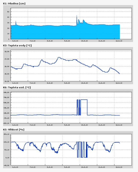
Teplota vzduchu a vody, vlhkost ,
 https://stanice.fiedler-magr.cz
Archiv
27_201326_2013
25_2013
24_2013
23_2013
22_2013
21_2013
20_2013
19_2013
18_2013
17_2013
16_2013
15_2013
14_2013
13_2013
12_2013
11_2013
10_2013
09_2013
08_2013
07_2013
06_2013
05_2013
04_2013
03_2013
02_2013
01_2013

 | Zemědělská 1/1665 613 00 Brno Budova D | Tel.: +420 545 133 350 Fax.: +420 545 212 044 |  |
 |