

Je hanba, že se někdo dovede namáhat po mnoho let, aby se stal dobrým lékařem, obhájcem, učitelem nebo geometrem, a přitom není ochoten namáhat se příslušně dlouhý čas, aby se stal dobrým člověkem.
Galénos z Pergamu
Konference
Konference v roce 2015
Konference v roce 2014
Konference v roce 2013
Konference v roce 2012
Konference v roce 2011


Polní laboratoř
NASA's TRMM Satellite Sees New Tropical Depression Forming Near Australia's Kimberly Coast
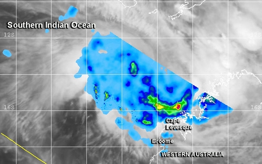 Low pressure System 98S appears ripe to form into Tropical Cyclone 05S as NASA satellite imagery is showing some hot towering clouds in the storm and heaviest rains south of the center. System 98S is expected to become a tropical depression on Saturday, December 28, and alerts are already in effect.
NASA and the Japan Aerospace and Exploration Agency's Tropical Rainfall Measuring Mission or TRMM satellite passed over developing System 98S on December 26 at 1140 UTC/6:40 a.m. EST and noticed a "hot tower" thunderstorm reaching heights of about 17 km/10.5 miles.
Low pressure System 98S appears ripe to form into Tropical Cyclone 05S as NASA satellite imagery is showing some hot towering clouds in the storm and heaviest rains south of the center. System 98S is expected to become a tropical depression on Saturday, December 28, and alerts are already in effect.
NASA and the Japan Aerospace and Exploration Agency's Tropical Rainfall Measuring Mission or TRMM satellite passed over developing System 98S on December 26 at 1140 UTC/6:40 a.m. EST and noticed a "hot tower" thunderstorm reaching heights of about 17 km/10.5 miles.
A "hot tower" is a tall cumulonimbus cloud that reaches at least to the top of the troposphere, the lowest layer of the atmosphere. It extends approximately 9 miles/14.5 km high in the tropics. These towers are called "hot" because they rise to such altitude due to the large amount of latent heat. Water vapor releases this latent heat as it condenses into liquid. NASA research shows that a tropical cyclone with a hot tower in its eye wall was twice as likely to intensify within six or more hours, than a cyclone that lacked a hot tower.
When TRMM passed over System 98S again on December 27 at 1222 UTC/7:22 a.m. EST, it observed heavy rainfall occurring falling at a rate of 1.4 inches/35.5 mm per hour. The heaviest rainfall appeared in a band of thunderstorms south of the center of circulation.
According to the Australian Bureau of Meteorology or ABM, System 98S was 250 nautical miles north-northwest of Broome (located along the Kimberly coast), Australia. System 98S is centered near 14.1 south and 120.9 east according to an interpretation of MTSAT-2 satellite imagery, conducted at the Joint Typhoon Warning Center. Maximum sustained winds are between 25 and 30 knots/28.7 to 34.5 mph/ 46.3 to 55.5 kph.
System 98S is expected to develop into Tropical Cyclone 05S on Saturday as it moves southwest, roughly parallel to the Kimberly coast of northwestern Australia.
Satellite imagery shows that strong convection and thunderstorms are building over the large low-level circulation center. Microwave imagery from a NOAA-19 polar orbiting satellite showed improved strong bands of thunderstorms over the southern quadrant of the storm and wrapping into the center. Low wind shear and warm sea surface temperatures are expected to assist System 98S in development.
ABM issued a Blue Alert for residents in or near coastal areas between Cape Leveque and Broome. Those areas can expect gusty winds as high as 100 kilometers/62.1 miles per hour on Saturday, December 28 and extend further southwest to De Grey by Sunday morning, December 29. Heavy rain is expected on Saturday in coastal areas of the Kimberley north of Broome. As System 98S organizes and moves it is expected to bring heavy rainfall and gusty winds on Sunday into Monday from Port Hedland to Mardie and Karratha. For updated warnings and watches, visit the ABM page: http://www.bom.gov.au/cyclone/index.shtml
Tropical Cyclone Bejisa Threatening Madagascar, La Reunion, and Mauritius
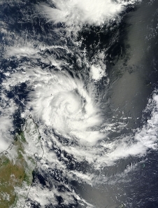
 Tropical Cyclone 06S quickly intensified within seven hours into named cyclone Bejisa on December 29, 2013. Reports had the cyclone moving erradically at first and then the cyclone was to intensify to about 75 knots. Currently Benjisa is located
620 nautical miles north northwest of La Reunion and has tracked southward at 5 knots over the past six hours. Maximum sustained winds currenlty are between 60 and 75 knots which is comparable to a tropical storm.
Maximum significant wave height is 15 feet.Favorable upper level environment in addition to warm sea surface temperature will promote further intensification of the storm. It is expected that Benjisa will peak at 90 knots giving it comparable strength to a hurricane.Benjisa will be at that strength upon passing near La Reunion and Mauritius on 3 January. Increasing vertical wind shear and westerly winds will then begin to weaken the system.
Tropical Cyclone 06S quickly intensified within seven hours into named cyclone Bejisa on December 29, 2013. Reports had the cyclone moving erradically at first and then the cyclone was to intensify to about 75 knots. Currently Benjisa is located
620 nautical miles north northwest of La Reunion and has tracked southward at 5 knots over the past six hours. Maximum sustained winds currenlty are between 60 and 75 knots which is comparable to a tropical storm.
Maximum significant wave height is 15 feet.Favorable upper level environment in addition to warm sea surface temperature will promote further intensification of the storm. It is expected that Benjisa will peak at 90 knots giving it comparable strength to a hurricane.Benjisa will be at that strength upon passing near La Reunion and Mauritius on 3 January. Increasing vertical wind shear and westerly winds will then begin to weaken the system.
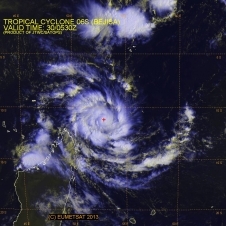
NASA Sees Cyclone Ian Affecting the Tonga Islands
 This visible image of Tropical Cyclone Ian was taken by the MODIS instrument aboard NASA's Aqua satellite on January 6, 2014 at 01:25 UTC when Ian was moving over the Tonga Islands, Pacific Ocean.
Cyclone Ian formed quickly and was affecting the Tonga Islands in the Southern Pacific Ocean on January 6, 2014 as NASA's Aqua satellite passed overhead and captured an image of the storm.
The Moderate Resolution Imaging Spectroradiometer or MODIS instrument took a picture of Ian at 01:25 UTC on Jan. 6/8:25 p.m. EST on Jan. 5. The MODIS image showed a tightly wrapped low-level circulation center the strongest thunderstorms flaring up along the northern quadrant of the storm. NASA's TRMM or Tropical Rainfall Measuring Mission satellite also showed that the strongest thunderstorms were pushed north of the center of circulation.
Tonga warnings are already in force. On January 6 there was a gale warning in effect for the Ha'apai and Va'vau island group, and a tropical cyclone alert in effect for the rest of Tonga.
On January 6 at 1500 UTC/10 a.m. EST, Ian's maximum sustained winds were near 35 knots/40 mph/62 kph. Tropical Cyclone Ian is centered near 19.0 south latitude and 175.6 west longitude, about 351 nautical miles east of Suva, Fiji. Ian has no large weather system to guide it and has tracked westward at 1 knot/1 mph/1 kph.
Forecasters at the Joint Typhoon Warning Center expect Ian to make half a circle heading from a southwesterly to a southeasterly direction over the next day.
This visible image of Tropical Cyclone Ian was taken by the MODIS instrument aboard NASA's Aqua satellite on January 6, 2014 at 01:25 UTC when Ian was moving over the Tonga Islands, Pacific Ocean.
Cyclone Ian formed quickly and was affecting the Tonga Islands in the Southern Pacific Ocean on January 6, 2014 as NASA's Aqua satellite passed overhead and captured an image of the storm.
The Moderate Resolution Imaging Spectroradiometer or MODIS instrument took a picture of Ian at 01:25 UTC on Jan. 6/8:25 p.m. EST on Jan. 5. The MODIS image showed a tightly wrapped low-level circulation center the strongest thunderstorms flaring up along the northern quadrant of the storm. NASA's TRMM or Tropical Rainfall Measuring Mission satellite also showed that the strongest thunderstorms were pushed north of the center of circulation.
Tonga warnings are already in force. On January 6 there was a gale warning in effect for the Ha'apai and Va'vau island group, and a tropical cyclone alert in effect for the rest of Tonga.
On January 6 at 1500 UTC/10 a.m. EST, Ian's maximum sustained winds were near 35 knots/40 mph/62 kph. Tropical Cyclone Ian is centered near 19.0 south latitude and 175.6 west longitude, about 351 nautical miles east of Suva, Fiji. Ian has no large weather system to guide it and has tracked westward at 1 knot/1 mph/1 kph.
Forecasters at the Joint Typhoon Warning Center expect Ian to make half a circle heading from a southwesterly to a southeasterly direction over the next day.
NASA Caught the Short-Lived Tropical Cyclone 01B in Action
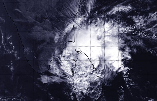 Tropical Cyclone 01B lived and died in the Northern Indian Ocean over the course of January 4 and 5, 2014, and NASA's Terra satellite captured an image of the storm at the end of its life.
NASA's Terra satellite passed over the remnants of Tropical Cyclone 01B on January 6 at 0500 UTC/12 a.m. EST, and the Moderate Resolution Imaging Spectroradiometer or MODIS instrument captured a visible image of the storm. At that time, the remnants were over northern Sri Lanka and southeastern India. Just 13 hours later the remnants dissipated over land.
Tropical Cyclone 01B was born on January 4 about 260 nautical miles/299.2 miles/481.5 km south-southeast of Chennai, India, near 9.3 north latitude and 92.4 east longitude. By 2100 UTC/4 p.m. EST that day, 01B's maximum sustained winds had increased to near 40 knots/46 mph/74 kph and only extended 40 nautical miles/46 miles/74 km out from the center. The storm was moving to the west-northwest at 4 knots/4.6 mph/7.4 kph.
By January 5, 2014 at 2100 UTC/4 p.m. EST, 01B's maximum sustained winds dropped to 35 knots/40 mph/62 kph and were weakening from wind shear. The last advisory on the tropical cyclone was issued when the storm was about 235 nautical miles/270.4 miles/435.2 km south-southeast of Chennai, India, near 9.3 north and 91.2 east. The storm was moving to the west at just 3 knots/3.4 mph/5.5 kph as it was being torn apart by wind shear.
Despite the weakening, a Blue Alert remained in effect for the residents of La Reunion Island, but that was dropped on January 6 as the storm dissipated.
Tropical Cyclone 01B lived and died in the Northern Indian Ocean over the course of January 4 and 5, 2014, and NASA's Terra satellite captured an image of the storm at the end of its life.
NASA's Terra satellite passed over the remnants of Tropical Cyclone 01B on January 6 at 0500 UTC/12 a.m. EST, and the Moderate Resolution Imaging Spectroradiometer or MODIS instrument captured a visible image of the storm. At that time, the remnants were over northern Sri Lanka and southeastern India. Just 13 hours later the remnants dissipated over land.
Tropical Cyclone 01B was born on January 4 about 260 nautical miles/299.2 miles/481.5 km south-southeast of Chennai, India, near 9.3 north latitude and 92.4 east longitude. By 2100 UTC/4 p.m. EST that day, 01B's maximum sustained winds had increased to near 40 knots/46 mph/74 kph and only extended 40 nautical miles/46 miles/74 km out from the center. The storm was moving to the west-northwest at 4 knots/4.6 mph/7.4 kph.
By January 5, 2014 at 2100 UTC/4 p.m. EST, 01B's maximum sustained winds dropped to 35 knots/40 mph/62 kph and were weakening from wind shear. The last advisory on the tropical cyclone was issued when the storm was about 235 nautical miles/270.4 miles/435.2 km south-southeast of Chennai, India, near 9.3 north and 91.2 east. The storm was moving to the west at just 3 knots/3.4 mph/5.5 kph as it was being torn apart by wind shear.
Despite the weakening, a Blue Alert remained in effect for the residents of La Reunion Island, but that was dropped on January 6 as the storm dissipated.
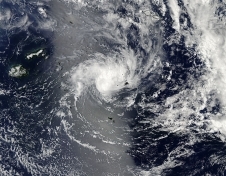
NASA Sees Heavy Rain in Newborn Tropical Cyclone Colin's Center
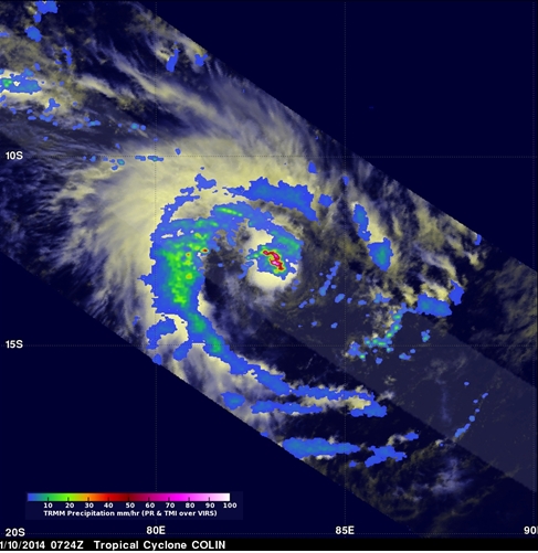 The TRMM satellite passed over newborn Tropical Cyclone Colin in the Southern Indian Ocean today, January 10 and spotted heavy rain falling near the intensifying storm's center. On January 10,2014 at 0724 UTC/2:24 a.m. EST the Tropical Rainfall Measuring Mission satellite known as TRMM passed directly above tropical cyclone Colin in the Southern Indian Ocean. At NASA's Goddard Space Flight Center in Greenbelt, Md. rainfall data derived from TRMM's Precipitation Radar (PR) and Microwave Imager (TMI) was overlaid on visible/infrared images from the Visible and InfraRed Scanner (VIRS). TRMM PR found Tropical Cyclone Colin contained precipitation falling at the amazing rate of over 224 mm/8.8 inches per hour near the powerful tropical cyclone's eye. The TRMM satellite is co-managed by NASA and the Japan Aerospace Exploration Agency. On January 10, 2014 at 0900 UTC/4 a.m. EST, Tropical Cyclone Colin, the eighth tropical cyclone in the Southern Indian Ocean was about 737 nautical miles/848 miles/1,365 km east-southeast of Diego Garcia near 12.5 south and 83.7 east. Colin is also known as "Cyclone 06/2013/2014" on La Reunion Island. Colin is moving to the west-southwest at 13 knots/14.9 mph/24.0 kph and has maximum sustained winds near 35 knots/40 mph/62 kph. Colin is expected to reach hurricane strength over the next several days before weakening.
The Joint Typhoon Warning Center, the forecast organization that covers the Southern Indian Ocean, noted that Colin is expected to track over open waters, heading west and later turning to the southwest while intensifying.
The TRMM satellite passed over newborn Tropical Cyclone Colin in the Southern Indian Ocean today, January 10 and spotted heavy rain falling near the intensifying storm's center. On January 10,2014 at 0724 UTC/2:24 a.m. EST the Tropical Rainfall Measuring Mission satellite known as TRMM passed directly above tropical cyclone Colin in the Southern Indian Ocean. At NASA's Goddard Space Flight Center in Greenbelt, Md. rainfall data derived from TRMM's Precipitation Radar (PR) and Microwave Imager (TMI) was overlaid on visible/infrared images from the Visible and InfraRed Scanner (VIRS). TRMM PR found Tropical Cyclone Colin contained precipitation falling at the amazing rate of over 224 mm/8.8 inches per hour near the powerful tropical cyclone's eye. The TRMM satellite is co-managed by NASA and the Japan Aerospace Exploration Agency. On January 10, 2014 at 0900 UTC/4 a.m. EST, Tropical Cyclone Colin, the eighth tropical cyclone in the Southern Indian Ocean was about 737 nautical miles/848 miles/1,365 km east-southeast of Diego Garcia near 12.5 south and 83.7 east. Colin is also known as "Cyclone 06/2013/2014" on La Reunion Island. Colin is moving to the west-southwest at 13 knots/14.9 mph/24.0 kph and has maximum sustained winds near 35 knots/40 mph/62 kph. Colin is expected to reach hurricane strength over the next several days before weakening.
The Joint Typhoon Warning Center, the forecast organization that covers the Southern Indian Ocean, noted that Colin is expected to track over open waters, heading west and later turning to the southwest while intensifying.
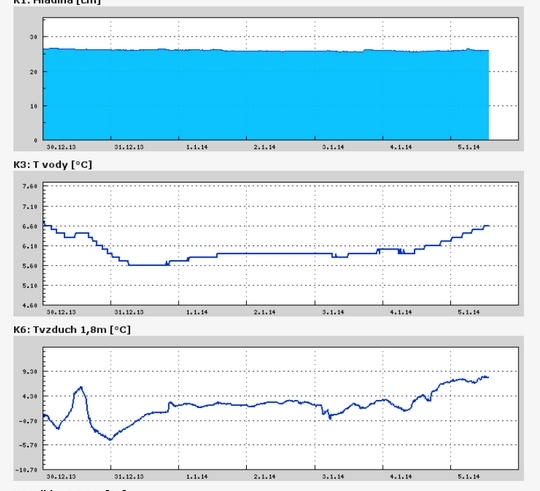
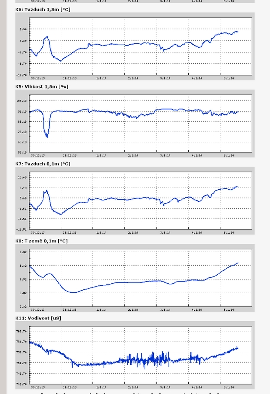
Teplota vzduchu a vody, vlhkost ,
 https://stanice.fiedler-magr.cz
Archiv
44_201343_2013
42_2013
41_2013
40_2013
39_2013
38_2013
37_2013
36_2013
35_2013
34_2013
33_2013
32_2013
31_2013
30_2013
29_2013
28_2013
27_2013
26_2013
25_2013
24_2013
23_2013
22_2013
21_2013
20_2013
19_2013
18_2013
17_2013
16_2013
15_2013
14_2013
13_2013
12_2013
11_2013
10_2013
09_2013
08_2013
07_2013
06_2013
05_2013
04_2013
03_2013
02_2013
01_2013

 | Zemědělská 1/1665 613 00 Brno Budova D | Tel.: +420 545 133 350 Fax.: +420 545 212 044 |  |
 |