

Tajemství vládnutí spočívá totiž v tom, jak spojit víru ve vlastní neomylnost se schopností učit se z minulých chyb.
George Orwell
Konference
Konference v roce 2015
Konference v roce 2014
Konference v roce 2013
Konference v roce 2012
Konference v roce 2011


Polní laboratoř
NASA Animation Shows Birth of Thirteenth Atlantic Tropical Depression
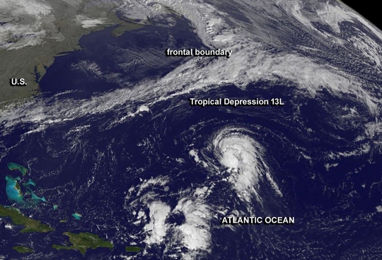 The thirteenth tropical depression of the Atlantic Ocean season formed today, Oct. 21 and NOAA's GOES-East satellite captured its development. NASA's GOES Project created an animation from the NOAA satellite imagery that shows the depression's development over three days.On Oct. 21 at 11 a.m. EDT/1500 UTC, Tropical Depression 13L was born about 650 miles/1,045 km east-southeast of Bermuda near 28.0 north and 55.1 west. It had maximum sustained winds near 35 mph/55 kph and some strengthening is expected. Tropical Depression 13L is moving to the northeast at 8 mph/13 kph and is expected to continue for a day before turning to the east-northeast.In a 29 second animation of GOES-East satellite imagery from Oct. 19 through 21, the formation of the depression can be seen over 600 miles east-southeast of Bermuda. The animation was created by the NASA GOES Project at NASA's
Goddard Space Flight Center in Greenbelt, Md.Forecasters at the National Hurricane Center noted that satellite imagery showed a long curved band of thunderstorms over the eastern semicircle of the center of circulation. There is also a small cluster of convection (rising air that forms thunderstorms that make up the tropical cyclone) on the east side of the low-level center. Forecasters at the National Hurricane Center expect the depression to strengthen into a tropical storm. If it does become a tropical storm it would be named "Lorenzo."
The thirteenth tropical depression of the Atlantic Ocean season formed today, Oct. 21 and NOAA's GOES-East satellite captured its development. NASA's GOES Project created an animation from the NOAA satellite imagery that shows the depression's development over three days.On Oct. 21 at 11 a.m. EDT/1500 UTC, Tropical Depression 13L was born about 650 miles/1,045 km east-southeast of Bermuda near 28.0 north and 55.1 west. It had maximum sustained winds near 35 mph/55 kph and some strengthening is expected. Tropical Depression 13L is moving to the northeast at 8 mph/13 kph and is expected to continue for a day before turning to the east-northeast.In a 29 second animation of GOES-East satellite imagery from Oct. 19 through 21, the formation of the depression can be seen over 600 miles east-southeast of Bermuda. The animation was created by the NASA GOES Project at NASA's
Goddard Space Flight Center in Greenbelt, Md.Forecasters at the National Hurricane Center noted that satellite imagery showed a long curved band of thunderstorms over the eastern semicircle of the center of circulation. There is also a small cluster of convection (rising air that forms thunderstorms that make up the tropical cyclone) on the east side of the low-level center. Forecasters at the National Hurricane Center expect the depression to strengthen into a tropical storm. If it does become a tropical storm it would be named "Lorenzo."
NASA Sees Major Hurricane Raymond Lashing Western Mexico
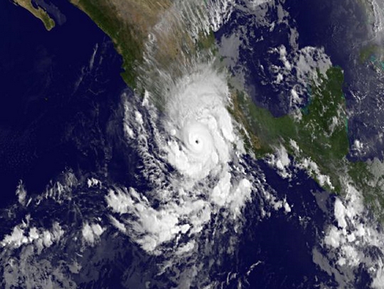 Low pressure System 96E developed quickly over the weekend of Oct. 19 and 20 and by Oct. 21 had grown into Hurricane Raymond. Before Raymond exploded into a major hurricane NASA's Terra satellite flew overhead from space and NOAA's GOES satellite provided images of Raymond as a major hurricane.
On Oct. 19 at 11 p.m. EDT, System 96E organized into Tropical Depression 17-E about 205 miles/330 km south of Acapulco, Mexico. By 5 a.m. EDT on Oct. 20, the depression strengthen into Tropical Storm Raymond.
NASA's Terra satellite flew over Raymond on Oct. 20 at 1800 UTC/2 p.m. EDT when it was a tropical storm off the coast of southwestern Mexico. The visible image was taken by the Moderate Resolution Imaging Spectroradiometer instrument and showed that clouds associated with Raymond's northern quadrant were streaming over mainland Mexico, despite the center being over open water. Six hours later, Raymond reached hurricane strength with maximum sustained winds near 75 mph/120 kph.
On Oct. 21 Hurricane warnings and watches were in effect as Raymond brought heavy rains, gusty winds and rough seas to western Mexico.
A Hurricane Warning was posted from Tecpan De Galeana to Lazaro Cardenas, while a Hurricane Watch was in effect from Acapulco to Tecpan De Galeana. In addition, a Tropical Storm Warning was In effect from Acapulco to Tecpan De Galeana.
At 8 a.m. EDT/1200 UTC, Hurricane Raymond's maximum sustained winds were around 120 mph/195 kph making it a major hurricane. A "major hurricane" is a storm reaching Category 3 or higher on the Saffir-Simpson scale that measures hurricane intensity. Some strengthening is possible during the next day or so, according to the National Hurricane Center.
Raymond's center or eye was located near latitude 16.2 north and longitude 102.3 west, about 115 miles/185 km south-southwest of Zihuatanejo, Mexico. That's also about 165 miles/265 km west-southwest of Acapulco.
Raymond is crawling northward at 2 mph/4 kph, which means a longer lashing of coastal Mexico. The National Hurricane Center (NHC) expects Raymond will continue to drift northward and closer to the coast today.
NOAA's GOES-West satellite took an infrared image of Hurricane Raymond on Oct. 21 at 1200 UTC/8 a.m. EDT when it was a major hurricane and it was lashing western Mexico. The image clearly showed Raymond's eye. At NASA's Goddard Space Flight Center in Greenbelt, Md. NASA's GOES Project created the image using data from the NOAA satellite.
In addition to hurricane-force winds, storm surge accompanied by large and destructive waves is expected to produce significant coastal flooding in areas of onshore flow within the warning areas. Rainfall expected from the storm is forecast to be between 2 to 4 inches with isolated amounts up to 8 inches over the Mexican state of Guerrero and Michoacan. For updated warnings and watches visit the National Hurricane Center webpage: www.nhc.noaa.gov
Low pressure System 96E developed quickly over the weekend of Oct. 19 and 20 and by Oct. 21 had grown into Hurricane Raymond. Before Raymond exploded into a major hurricane NASA's Terra satellite flew overhead from space and NOAA's GOES satellite provided images of Raymond as a major hurricane.
On Oct. 19 at 11 p.m. EDT, System 96E organized into Tropical Depression 17-E about 205 miles/330 km south of Acapulco, Mexico. By 5 a.m. EDT on Oct. 20, the depression strengthen into Tropical Storm Raymond.
NASA's Terra satellite flew over Raymond on Oct. 20 at 1800 UTC/2 p.m. EDT when it was a tropical storm off the coast of southwestern Mexico. The visible image was taken by the Moderate Resolution Imaging Spectroradiometer instrument and showed that clouds associated with Raymond's northern quadrant were streaming over mainland Mexico, despite the center being over open water. Six hours later, Raymond reached hurricane strength with maximum sustained winds near 75 mph/120 kph.
On Oct. 21 Hurricane warnings and watches were in effect as Raymond brought heavy rains, gusty winds and rough seas to western Mexico.
A Hurricane Warning was posted from Tecpan De Galeana to Lazaro Cardenas, while a Hurricane Watch was in effect from Acapulco to Tecpan De Galeana. In addition, a Tropical Storm Warning was In effect from Acapulco to Tecpan De Galeana.
At 8 a.m. EDT/1200 UTC, Hurricane Raymond's maximum sustained winds were around 120 mph/195 kph making it a major hurricane. A "major hurricane" is a storm reaching Category 3 or higher on the Saffir-Simpson scale that measures hurricane intensity. Some strengthening is possible during the next day or so, according to the National Hurricane Center.
Raymond's center or eye was located near latitude 16.2 north and longitude 102.3 west, about 115 miles/185 km south-southwest of Zihuatanejo, Mexico. That's also about 165 miles/265 km west-southwest of Acapulco.
Raymond is crawling northward at 2 mph/4 kph, which means a longer lashing of coastal Mexico. The National Hurricane Center (NHC) expects Raymond will continue to drift northward and closer to the coast today.
NOAA's GOES-West satellite took an infrared image of Hurricane Raymond on Oct. 21 at 1200 UTC/8 a.m. EDT when it was a major hurricane and it was lashing western Mexico. The image clearly showed Raymond's eye. At NASA's Goddard Space Flight Center in Greenbelt, Md. NASA's GOES Project created the image using data from the NOAA satellite.
In addition to hurricane-force winds, storm surge accompanied by large and destructive waves is expected to produce significant coastal flooding in areas of onshore flow within the warning areas. Rainfall expected from the storm is forecast to be between 2 to 4 inches with isolated amounts up to 8 inches over the Mexican state of Guerrero and Michoacan. For updated warnings and watches visit the National Hurricane Center webpage: www.nhc.noaa.gov
Tropical Storm Lekima Born in Northwestern Pacific Ocean
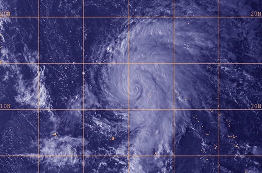 The twenty-eighth tropical depression of the Northwestern Pacific Ocean tropical cyclone season developed and strengthened into Tropical Storm Lekima.
On Oct. 21 at 1500 UTC/11 a.m. EDT, Tropical Storm Lekima had maximum sustained winds near 55 knots/63.2 mph/101.9 kph. It was centered near 13.6 north and 159.4 east, about 815 nautical miles/ 937.9 miles/1,509 km east of Saipan. Lekima was moving to the north-northwest at 10 knots/11.5 mph/18.5 kph.
A visible image of Tropical Storm Lekima was obtained by Japan's MTSAT-2 satellite on Oct. 21 at 0532 UTC/1:32 a.m. EDT. Additional infrared satellite imagery showed that the tropical storm was organizing and consolidating. Imagery showed that bands of thunderstorms were wrapping around the well-defined center of circulation, and a pinhole eye-like feature.
Forecasters at the Joint Typhoon Warning Center expect Lekima to strengthen to typhoon strength in the next day. Lekima's maximum sustained winds are expected to peak near 115 knots/132.3 mph/213 kph by Oct. 24 as it continues to move over open waters of the Northwestern Pacific. Lekima is forecast to approach Iwo To on Oct. 24, and then turn to the northeast away from the island.
The twenty-eighth tropical depression of the Northwestern Pacific Ocean tropical cyclone season developed and strengthened into Tropical Storm Lekima.
On Oct. 21 at 1500 UTC/11 a.m. EDT, Tropical Storm Lekima had maximum sustained winds near 55 knots/63.2 mph/101.9 kph. It was centered near 13.6 north and 159.4 east, about 815 nautical miles/ 937.9 miles/1,509 km east of Saipan. Lekima was moving to the north-northwest at 10 knots/11.5 mph/18.5 kph.
A visible image of Tropical Storm Lekima was obtained by Japan's MTSAT-2 satellite on Oct. 21 at 0532 UTC/1:32 a.m. EDT. Additional infrared satellite imagery showed that the tropical storm was organizing and consolidating. Imagery showed that bands of thunderstorms were wrapping around the well-defined center of circulation, and a pinhole eye-like feature.
Forecasters at the Joint Typhoon Warning Center expect Lekima to strengthen to typhoon strength in the next day. Lekima's maximum sustained winds are expected to peak near 115 knots/132.3 mph/213 kph by Oct. 24 as it continues to move over open waters of the Northwestern Pacific. Lekima is forecast to approach Iwo To on Oct. 24, and then turn to the northeast away from the island.
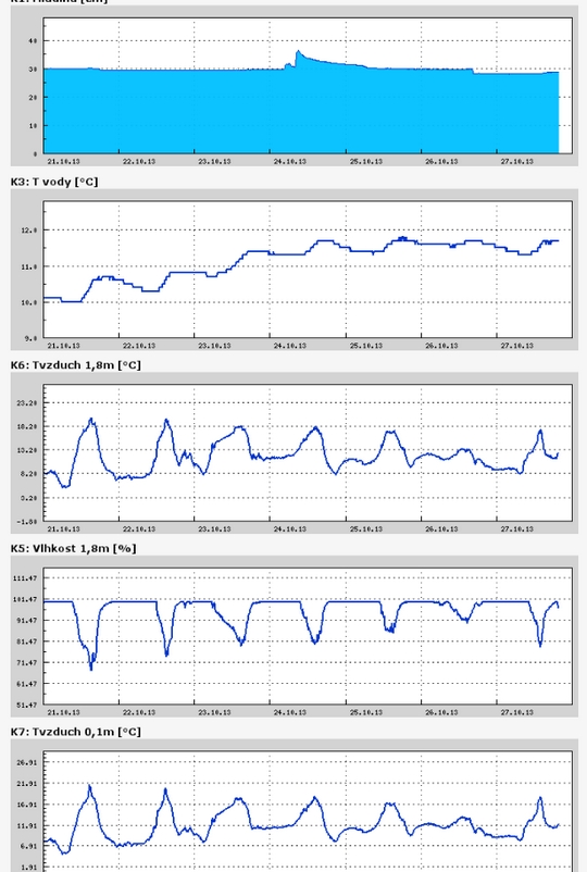
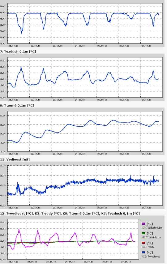
Teplota vzduchu a vody, vlhkost ,
 https://stanice.fiedler-magr.cz
Archiv
36_201335_2013
34_2013
33_2013
32_2013
31_2013
30_2013
29_2013
28_2013
27_2013
26_2013
25_2013
24_2013
23_2013
22_2013
21_2013
20_2013
19_2013
18_2013
17_2013
16_2013
15_2013
14_2013
13_2013
12_2013
11_2013
10_2013
09_2013
08_2013
07_2013
06_2013
05_2013
04_2013
03_2013
02_2013
01_2013

 | Zemědělská 1/1665 613 00 Brno Budova D | Tel.: +420 545 133 350 Fax.: +420 545 212 044 |  |
 |