

Vědět a znát, to mnohý by chtěl, ale učit se nechce.
Walther Von Der Vegelweide
Konference
Konference v roce 2015
Konference v roce 2014
Konference v roce 2013
Konference v roce 2012
Konference v roce 2011


Polní laboratoř
From Birth to Death in Four Days: Kiko Now a Remnant Low
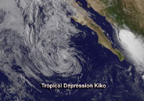 A lot of things happen over a holiday weekend, and while people in the United States were celebrating Labor Day weekend, the Eastern Pacific Ocean's Tropical Storm Kiko came and went. Satellite data captured Tropical Storm Kiko's birth on Sept. 1 and saw its remnants weakening on Sept. 3. As Kiko dissipates, another low pressure system is forming near the southwestern coast of Mexico.NOAA's GOES-West satellite captured the life of Kiko from the time it became Tropical Depression 11 on Aug. 31. The depression formed about 500 miles/805 km west-southwest of the southern tip of Baja California and appeared elongated.The next day, a GOES-West satellite image revealed that the depression organized and Tropical Storm Kiko was born at 11 a.m. EDT. Kiko intensified quickly as it continued moving north at 7 mph/11 kph and its maximum sustained winds sped up to near 70 mph, just 4 mph shy of hurricane-force. At that time, te center of Tropical Storm Kiko was located near latitude 21.3 north and longitude 115.6 west, 380 miles west-southwest of the southern tip of Baja California. By 11 a.m. EDT on Sept. 2, Kiko had run into cooler waters and wind shear, weakening the storm. Tropical Depression Kiko's maximum sustained winds had dropped to near 35 mph/55 kph. It was centered near latitude 22.9 north and longitude 116.4, about 415 miles/665 km west of the southern tip of Baja California, Mexico. Kiko was moving toward the northwest near 2 mph/4 kph. NOAA's GOES-West satellite captured an infrared image of Kiko on Monday, Sept. 2 at 1500 UTC/11 a.m. EDT/8 a.m. PDT that showed the circulation had weakened. The image was created by NASA's GOES Project at NASA's Goddard Space Flight Center in Greenbelt, Md.
On Tuesday, Sept. 3, Kiko was a post-tropical remnant low pressure area near 23 north and 116.5 west. The National Hurricane Center noted that Kiko's remnants will continue to weaken, and the short-lived storm will dissipate by Sept. 4. As Kiko dissipates, another low pressure area appears to be organizing in the Eastern Pacific.The other low is located a couple of hundred miles southwest of Mexico's southwestern coast. It is generating widespread showers and is expected to develop over the next several days. The National Hurricane Center gives that low a 50 percent chance of becoming a tropical depression in the next several days as it moves to the west-northwest. Because of its close proximity to land, southwestern Mexico may experience heavy rainfall and gusty winds from the system over the next couple of days.
A lot of things happen over a holiday weekend, and while people in the United States were celebrating Labor Day weekend, the Eastern Pacific Ocean's Tropical Storm Kiko came and went. Satellite data captured Tropical Storm Kiko's birth on Sept. 1 and saw its remnants weakening on Sept. 3. As Kiko dissipates, another low pressure system is forming near the southwestern coast of Mexico.NOAA's GOES-West satellite captured the life of Kiko from the time it became Tropical Depression 11 on Aug. 31. The depression formed about 500 miles/805 km west-southwest of the southern tip of Baja California and appeared elongated.The next day, a GOES-West satellite image revealed that the depression organized and Tropical Storm Kiko was born at 11 a.m. EDT. Kiko intensified quickly as it continued moving north at 7 mph/11 kph and its maximum sustained winds sped up to near 70 mph, just 4 mph shy of hurricane-force. At that time, te center of Tropical Storm Kiko was located near latitude 21.3 north and longitude 115.6 west, 380 miles west-southwest of the southern tip of Baja California. By 11 a.m. EDT on Sept. 2, Kiko had run into cooler waters and wind shear, weakening the storm. Tropical Depression Kiko's maximum sustained winds had dropped to near 35 mph/55 kph. It was centered near latitude 22.9 north and longitude 116.4, about 415 miles/665 km west of the southern tip of Baja California, Mexico. Kiko was moving toward the northwest near 2 mph/4 kph. NOAA's GOES-West satellite captured an infrared image of Kiko on Monday, Sept. 2 at 1500 UTC/11 a.m. EDT/8 a.m. PDT that showed the circulation had weakened. The image was created by NASA's GOES Project at NASA's Goddard Space Flight Center in Greenbelt, Md.
On Tuesday, Sept. 3, Kiko was a post-tropical remnant low pressure area near 23 north and 116.5 west. The National Hurricane Center noted that Kiko's remnants will continue to weaken, and the short-lived storm will dissipate by Sept. 4. As Kiko dissipates, another low pressure area appears to be organizing in the Eastern Pacific.The other low is located a couple of hundred miles southwest of Mexico's southwestern coast. It is generating widespread showers and is expected to develop over the next several days. The National Hurricane Center gives that low a 50 percent chance of becoming a tropical depression in the next several days as it moves to the west-northwest. Because of its close proximity to land, southwestern Mexico may experience heavy rainfall and gusty winds from the system over the next couple of days.
NASA Satellite Sees Tropical Storm Toraji's Concentrated Center Approaching Japan
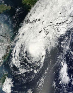 This visible image of Tropical Storm Toraji was captured on Sept. 3 at 02:10 UTC by the MODIS instrument that flies aboard NASA's Terra satellite. Toraji was approaching southern Japan.
A visible image of Tropical Storm Toraji was captured on Sept. 3 at 02:10 UTC/Sept. 2 at 10:10 p.m. is it continued moving north past eastern China and approached southern Japan. The image was taken by the Moderate Resolution Imaging Spectroradiometer or MODIS instrument that flies aboard NASA's Terra satellite. The image showed strong thunderstorms wrapped around the center of the tropical storm. Bands of thunderstorms wrapping into the center from the north extended over Kyushu. Kyushu is the third largest island of Japan and is farthest southwest of Japan's four main islands. At 1500 UTC/11 a.m. EDT on Monday, Sept. 2, Toraji had maximum sustained winds near 35 knots/40 mph/64 kph, so it was a minimal tropical storm. It was located about 100 miles northwest of Kadena Air Base, Okinawa, near 27.7 north and 126.5 west. Toraji was generating 13-foot/3.9-meter-high seas. That day, infrared satellite data from the MODIS instrument aboard NASA's Aqua satellite showed strong bands of thunderstorms wrapping around the southeastern and eastern quadrant of the storm, and spinning into the low-level center of circulation. Aqua passed over Toraji on Sept. 2 at 1328 UTC/9:28 a.m. EDT.By Monday, Sept. 3 at 1500 UTC/11 a.m. EDT, Toraji's maximum sustained winds increased to 50 knots/57.5 mph/92.6 kph. The strongest winds are in the northeastern quadrant of the storm. Toraji moved closed to Kyushu and was centered near 30.5 north and 129.3 east, about 172 nautical miles/198 miles/318 km south-southwest of Sasebo, Japan. Toraji is moving to the northeast at 9 knots/10.3 mph/16.6 kph. Wind shear has increased from the southwest today, Sept. 3. A deep layered mid-latitude trough (elongated area of low pressure) located over the Yellow Sea has created strong vertical wind shear. Winds are blowing from the southwest at up to 30 knots/34.5 mph/55.5 kph. Toraji is now expected to make landfall in Kyushu and move back over open waters in the Sea of Japan where it is expected to parallel the western coast of Japan. It is expected to begin interacting with mid-level westerly winds and the Baroclinic Zone and become extra-tropical later today. According to NOAA, the Baroclinic Zone is a region in which a temperature gradient exists on a constant pressure surface. Baroclinic zones are favored areas for strengthening and weakening systems; barotropic systems, on the other hand, do not exhibit significant changes in intensity. Also, wind shear is characteristic of a baroclinic zone, and wind shear can tear tropical cyclones apart.
Between the increased wind shear from the southwest and the interaction with the land (Kyushu), Tropical Storm Toraji is not expected to intensify before making landfall.
This visible image of Tropical Storm Toraji was captured on Sept. 3 at 02:10 UTC by the MODIS instrument that flies aboard NASA's Terra satellite. Toraji was approaching southern Japan.
A visible image of Tropical Storm Toraji was captured on Sept. 3 at 02:10 UTC/Sept. 2 at 10:10 p.m. is it continued moving north past eastern China and approached southern Japan. The image was taken by the Moderate Resolution Imaging Spectroradiometer or MODIS instrument that flies aboard NASA's Terra satellite. The image showed strong thunderstorms wrapped around the center of the tropical storm. Bands of thunderstorms wrapping into the center from the north extended over Kyushu. Kyushu is the third largest island of Japan and is farthest southwest of Japan's four main islands. At 1500 UTC/11 a.m. EDT on Monday, Sept. 2, Toraji had maximum sustained winds near 35 knots/40 mph/64 kph, so it was a minimal tropical storm. It was located about 100 miles northwest of Kadena Air Base, Okinawa, near 27.7 north and 126.5 west. Toraji was generating 13-foot/3.9-meter-high seas. That day, infrared satellite data from the MODIS instrument aboard NASA's Aqua satellite showed strong bands of thunderstorms wrapping around the southeastern and eastern quadrant of the storm, and spinning into the low-level center of circulation. Aqua passed over Toraji on Sept. 2 at 1328 UTC/9:28 a.m. EDT.By Monday, Sept. 3 at 1500 UTC/11 a.m. EDT, Toraji's maximum sustained winds increased to 50 knots/57.5 mph/92.6 kph. The strongest winds are in the northeastern quadrant of the storm. Toraji moved closed to Kyushu and was centered near 30.5 north and 129.3 east, about 172 nautical miles/198 miles/318 km south-southwest of Sasebo, Japan. Toraji is moving to the northeast at 9 knots/10.3 mph/16.6 kph. Wind shear has increased from the southwest today, Sept. 3. A deep layered mid-latitude trough (elongated area of low pressure) located over the Yellow Sea has created strong vertical wind shear. Winds are blowing from the southwest at up to 30 knots/34.5 mph/55.5 kph. Toraji is now expected to make landfall in Kyushu and move back over open waters in the Sea of Japan where it is expected to parallel the western coast of Japan. It is expected to begin interacting with mid-level westerly winds and the Baroclinic Zone and become extra-tropical later today. According to NOAA, the Baroclinic Zone is a region in which a temperature gradient exists on a constant pressure surface. Baroclinic zones are favored areas for strengthening and weakening systems; barotropic systems, on the other hand, do not exhibit significant changes in intensity. Also, wind shear is characteristic of a baroclinic zone, and wind shear can tear tropical cyclones apart.
Between the increased wind shear from the southwest and the interaction with the land (Kyushu), Tropical Storm Toraji is not expected to intensify before making landfall.
NASA Sees "Hot Towers" in Newborn Tropical Depression 12E Hinting at Intensification
Tropical Depression 12E formed off the southwestern coast of Mexico at 5 a.m. EDT on Sept. 5. Just 40 minutes before, NASA's TRMM satellite passed overhead and saw some "hot towers" around the center, indicating that the low pressure area that was previously known as System 99E would strengthen.
A "hot tower" is a tall cumulonimbus cloud that reaches at least to the top of the troposphere, the lowest layer of the atmosphere. It extends approximately nine miles (14.5 km) high in the tropics. The hot towers in Tropical Depression 12E were reaching heights of 15 km/9.3 miles high around the depression's center. These towers are called "hot" because they rise to such altitude due to the large amount of latent heat. Water vapor releases this latent heat as it condenses into liquid. NASA research shows that a tropical cyclone with a hot tower in its eye wall was twice as likely to intensify within six or more hours, than a cyclone that lacked a hot tower. Those hot towers also drop heavy rainfall.
On Thursday, Sept. 5 (today) at 4:20 a.m. EDT, NASA's TRMM satellite saw moderate rainfall in newborn Tropical Depression 12E off the southwestern coast of Mexico. Some of that rainfall extended over coastal areas. The National Hurricane Center expects locally heavy rainfall along the southwestern coast of Mexico today.
At 5 a.m. EDT/0900 UTC, Tropical Depression 12E had maximum sustained winds near 35 mph/55 kph. The National Hurricane Center expects the depression to strengthen further into a tropical storm later on Sept. 5. The center of 12E was located near latitude 17.6 north and longitude 106.1 west, about 155 miles/245 km southwest of Manzanillo, Mexico. The depression is moving toward the northwest near 6 mph/9 kph is expected to continue in that direction over the next couple of days.
NASA Satellite Animation Records Birth of Tropical Storm Gabrielle Near Puerto Rico
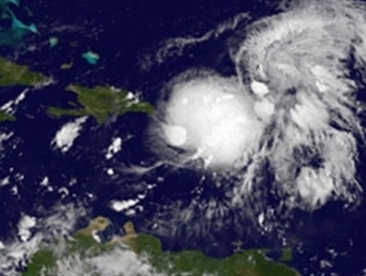 This GOES-East series of animations from Sept. 1 through Sept. 5 show the development of Tropical Depression 7 into Tropical Storm Gabrielle near Puerto Rico
One hour before midnight Eastern Daylight Time on Sept. 4, Tropical Depression 7 strengthened into Tropical Storm Gabrielle just 70 miles south of Ponce, Puerto Rico. NOAA's GOES-East satellite captured the development and NASA's GOES Project created an animation that showed the developing storm.
Tropical Depression Seven had formed at 5 p.m. EDT on Sept. 4 and just 6 hours later it organized and strengthened into Gabrielle. Tropical Storm Gabrielle was bringing heavy rains to Puerto Rico and adjacent islands during the morning of Sept. 5. NOAA's GOES-East satellite captured an image of Gabrielle at 7:32 a.m. EDT today, Sept. 5 that showed Gabrielle over Puerto Rico. NASA's GOES Project, located at the NASA Goddard Space Flight Center in Greenbelt, Md. compiled five days of images from Sept. 1 to Sept. 5 and created a seven second animation that shows the development of Gabrielle from the beginning.
NOAA's GOES-East satellite captured an image of Gabrielle at 7:32 a.m. EDT today, Sept. 5 that showed Gabrielle over Puerto Rico, at 5 a.m. EDT Gabrielle had maximum sustained winds near 40 mph.
By 8 a.m. EDT Gabrielle had maximum sustained winds near 40 mph/65 kph (mostly northwest of the center), and it was about 65 miles/105 km south-southwest of Ponce, Puerto Rico near 17.7 north and 67.4 west. It was moving to the northwest at 8 mph/13 kph and that motion is expected to continue today. Gabrielle had a minimum central pressure of 1008 millibars.
Radar images from Puerto Rico during the morning of Sept. 5 showed a well-defined mid-level center to the east of the surface location. On infrared satellite imagery, the surface center was difficult to find, but appeared to be on the western edge of the strongest convection and thunderstorms.
A Tropical Storm Warning is in effect for Puerto Rico and the Dominican Republic from Cabo Engano to Cabo Frances Viejo. A Tropical Storm Watch Is In Effect for the Dominican Republic from Santo Domingo to Cabo Engano.
According to the National Hurricane Center, Gabrielle is expected to produce total rainfall amounts of 3 to 6 inches over Puerto Rico, the U.S. Virgin Islands and eastern portions of the Dominican Republic with isolated maximum amounts of up to 12 inches possible in areas of mountainous terrain. Rainfall that large could cause dangerous flash floods and mudslides over mountainous terrain.
The National Hurricane Center expects Gabrielle's center to pass near or over the southwestern portion of Puerto Rico during the morning today, and across the Mona Passage later in the day. Gabrielle should then move east of the Turks and the Caicos Islands on Friday.
This GOES-East series of animations from Sept. 1 through Sept. 5 show the development of Tropical Depression 7 into Tropical Storm Gabrielle near Puerto Rico
One hour before midnight Eastern Daylight Time on Sept. 4, Tropical Depression 7 strengthened into Tropical Storm Gabrielle just 70 miles south of Ponce, Puerto Rico. NOAA's GOES-East satellite captured the development and NASA's GOES Project created an animation that showed the developing storm.
Tropical Depression Seven had formed at 5 p.m. EDT on Sept. 4 and just 6 hours later it organized and strengthened into Gabrielle. Tropical Storm Gabrielle was bringing heavy rains to Puerto Rico and adjacent islands during the morning of Sept. 5. NOAA's GOES-East satellite captured an image of Gabrielle at 7:32 a.m. EDT today, Sept. 5 that showed Gabrielle over Puerto Rico. NASA's GOES Project, located at the NASA Goddard Space Flight Center in Greenbelt, Md. compiled five days of images from Sept. 1 to Sept. 5 and created a seven second animation that shows the development of Gabrielle from the beginning.
NOAA's GOES-East satellite captured an image of Gabrielle at 7:32 a.m. EDT today, Sept. 5 that showed Gabrielle over Puerto Rico, at 5 a.m. EDT Gabrielle had maximum sustained winds near 40 mph.
By 8 a.m. EDT Gabrielle had maximum sustained winds near 40 mph/65 kph (mostly northwest of the center), and it was about 65 miles/105 km south-southwest of Ponce, Puerto Rico near 17.7 north and 67.4 west. It was moving to the northwest at 8 mph/13 kph and that motion is expected to continue today. Gabrielle had a minimum central pressure of 1008 millibars.
Radar images from Puerto Rico during the morning of Sept. 5 showed a well-defined mid-level center to the east of the surface location. On infrared satellite imagery, the surface center was difficult to find, but appeared to be on the western edge of the strongest convection and thunderstorms.
A Tropical Storm Warning is in effect for Puerto Rico and the Dominican Republic from Cabo Engano to Cabo Frances Viejo. A Tropical Storm Watch Is In Effect for the Dominican Republic from Santo Domingo to Cabo Engano.
According to the National Hurricane Center, Gabrielle is expected to produce total rainfall amounts of 3 to 6 inches over Puerto Rico, the U.S. Virgin Islands and eastern portions of the Dominican Republic with isolated maximum amounts of up to 12 inches possible in areas of mountainous terrain. Rainfall that large could cause dangerous flash floods and mudslides over mountainous terrain.
The National Hurricane Center expects Gabrielle's center to pass near or over the southwestern portion of Puerto Rico during the morning today, and across the Mona Passage later in the day. Gabrielle should then move east of the Turks and the Caicos Islands on Friday.
Satellite Sees Atlantic Tropical Depression Eight Form in Southwestern Gulf of Mexico
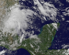 NOAA's GOES-East satellite captured the birth of Tropical Depression Eight in the southwestern Gulf of Mexico at 2:31 p.m. EDT on Sept. 6. The eighth tropical depression of the Atlantic Ocean hurricane season formed in the southwestern Gulf of Mexico at 2 p.m. EDT on Sept. 6, and NOAA's GOES-East satellite captured a visible image of the storm.
NOAA's GOES-East satellite image showed a large circulation associated with Tropical Depression 8 or TD8 after it was officially designated a depression by the National Hurricane Center. The image was created by NASA's GOES Project at the NASA Goddard Space Flight Center in Greenbelt, Md.
The center of TD8 formed right along the eastern coast of Mexico near Tampico and was making landfall after it formed. At 2:30 p.m. EDT, the center of the depression was directly over Tampico. It had maximum sustained winds near 35 mph/55 kph and was moving to the west-southwest at 6 mph/9 kph. Minimum central pressure is 1009 millibars. Despite making landfall quickly, there are no watches and warnings in effect, although it is expected to drop rainfall between 3 and 5 inches in the Mexican states of Veracruz and Tamaulipas. Some areas may receive isolated maximum amounts up to 10 inches, and could experience flash-flooding and mudslides.
According to the National Hurricane Center, TD8 is going to be short-lived because it is moving over land. In fact, the NHC expects the depression to become a remnant low pressure area over the weekend of Sept. 7 and 8 as it drops more rainfall on its track to the west-southwest.
NOAA's GOES-East satellite captured the birth of Tropical Depression Eight in the southwestern Gulf of Mexico at 2:31 p.m. EDT on Sept. 6. The eighth tropical depression of the Atlantic Ocean hurricane season formed in the southwestern Gulf of Mexico at 2 p.m. EDT on Sept. 6, and NOAA's GOES-East satellite captured a visible image of the storm.
NOAA's GOES-East satellite image showed a large circulation associated with Tropical Depression 8 or TD8 after it was officially designated a depression by the National Hurricane Center. The image was created by NASA's GOES Project at the NASA Goddard Space Flight Center in Greenbelt, Md.
The center of TD8 formed right along the eastern coast of Mexico near Tampico and was making landfall after it formed. At 2:30 p.m. EDT, the center of the depression was directly over Tampico. It had maximum sustained winds near 35 mph/55 kph and was moving to the west-southwest at 6 mph/9 kph. Minimum central pressure is 1009 millibars. Despite making landfall quickly, there are no watches and warnings in effect, although it is expected to drop rainfall between 3 and 5 inches in the Mexican states of Veracruz and Tamaulipas. Some areas may receive isolated maximum amounts up to 10 inches, and could experience flash-flooding and mudslides.
According to the National Hurricane Center, TD8 is going to be short-lived because it is moving over land. In fact, the NHC expects the depression to become a remnant low pressure area over the weekend of Sept. 7 and 8 as it drops more rainfall on its track to the west-southwest.
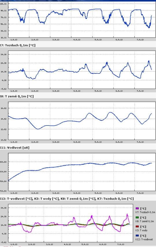
Teplota vzduchu a vody, vlhkost ,
 https://stanice.fiedler-magr.cz
Archiv
29_201328_2013
27_2013
26_2013
25_2013
24_2013
23_2013
22_2013
21_2013
20_2013
19_2013
18_2013
17_2013
16_2013
15_2013
14_2013
13_2013
12_2013
11_2013
10_2013
09_2013
08_2013
07_2013
06_2013
05_2013
04_2013
03_2013
02_2013
01_2013

 | Zemědělská 1/1665 613 00 Brno Budova D | Tel.: +420 545 133 350 Fax.: +420 545 212 044 |  |
 |