

Každý, kdo se přestane učit, je starý, ať je mu 20 nebo 80. Každý, kdo se stále učí, zůstává mladý. Je nejlepší v životě zůstat mladý.
Henry Ford
Konference
Konference v roce 2015
Konference v roce 2014
Konference v roce 2013
Konference v roce 2012
Konference v roce 2011


Polní laboratoř
NASA Sees Quick Forming Tropical Storm Fernand Soaking Mexico
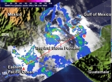 During the week of Aug. 18, the low pressure area designated as System 95E was lingering in the western Caribbean Sea and moved into the southwestern Gulf of Mexico, where it exploded into Tropical Storm Fernand late on Aug. 25. On Aug. 26, NASA's TRMM satellite saw towering thunderstorms in Fernand were still raging over mainland Mexico, dropping heavy rainfall. On Sunday, Aug. 25 at 5:00 p.m. EDT, System 95E organized quickly into a tropical depression six, and by 7:00 p.m. EDT, the depression strengthened into Tropical Storm Fernand. Fernand was centered in the Bay of Campeche and by 12:25 a.m. EDT on Aug. 26, Tropical Storm Fernand made landfall about 25 miles/40 km north-northwest of Veracruz, Mexico.
 This image of Fernand was taken from NOAA's GOES-East satellite at 7:45 a.m. EDT on Aug. 26, and shows that Fernand expanded after making landfall.
At landfall, Fernand's maximum sustained winds were near 50 mph/85 kph. It came ashore near 19.5 north and 96.3 west. Fernand is now moving toward the north-northwest over mainland Mexico dumping heavy rainfall to eastern portions of the country. A tropical storm warning is in effect for Veracruz northward to Barra de Nautla. NASA's Tropical Rainfall Measuring Mission satellite called TRMM can measure rainfall rates from space. When TRMM passed over Fernand on Monday, Aug. 26 at 05:34 UTC/1:34 a.m. EDT, data showed that "hot towers" or towering thunderstorms that stretch to the top of the troposphere were flaring around the storm's center. TRMM data showed rainfall rates exceeding 2 inches/50 mm per hour.
A "hot tower" is a tall cumulonimbus cloud that reaches at least to the top of the troposphere, the lowest layer of the atmosphere. It extends approximately nine miles (14.5 km) high in the tropics. The hot towers in Fernand were as high as 11.1 miles (18 km) high! These towers are called "hot" because they rise to such altitude due to the large amount of latent heat. Water vapor releases this latent heat as it condenses into liquid. NASA research shows that a tropical cyclone with a hot tower in its eye wall was twice as likely to intensify within six or more hours, than a cyclone that lacked a hot tower. Those hot towers also drop heavy rainfall, and the National Hurricane Center expects Fernand to produce 4 to 8 inches of rain over Veracruz, Hidalgo, northern Puebla, southern Tamaulipas and eastern San Luis Potosi, Mexico today, Aug. 26. Isolated maximum amounts of up to 12 inches are possible, and Fernand's rainfall could cause life-threatening flash floods and mud slides.At 8 a.m. EDT, the center of Tropical Storm Fernand was lLocated near latitude 20.1 north and longitude 97.2 west. That puts Fernand's center about 95 miles/150 km northwest of Veracruz, Mexico and just 65 miles/100 km south-southeast of Tuxpan, Mexico. The National Hurricane Center (NHC) noted that Fernand is moving toward the northwest near 9 mph/15 kph and this general motion is expected to continue for the next day or so with a slight decrease in forward speed. Fernand is expected to remain over Mexico tonight, Aug. 26 into Aug. 27. Maximum sustained winds have decreased to near 40 mph/65 kph, but weakening will continue while the system moves over land. The NHC expects Fernand to become a depression later today.
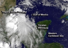
This image of Fernand was taken from NOAA's GOES-East satellite at 7:45 a.m. EDT on Aug. 26, and shows that Fernand expanded after making landfall.
At landfall, Fernand's maximum sustained winds were near 50 mph/85 kph. It came ashore near 19.5 north and 96.3 west. Fernand is now moving toward the north-northwest over mainland Mexico dumping heavy rainfall to eastern portions of the country. A tropical storm warning is in effect for Veracruz northward to Barra de Nautla. NASA's Tropical Rainfall Measuring Mission satellite called TRMM can measure rainfall rates from space. When TRMM passed over Fernand on Monday, Aug. 26 at 05:34 UTC/1:34 a.m. EDT, data showed that "hot towers" or towering thunderstorms that stretch to the top of the troposphere were flaring around the storm's center. TRMM data showed rainfall rates exceeding 2 inches/50 mm per hour.
A "hot tower" is a tall cumulonimbus cloud that reaches at least to the top of the troposphere, the lowest layer of the atmosphere. It extends approximately nine miles (14.5 km) high in the tropics. The hot towers in Fernand were as high as 11.1 miles (18 km) high! These towers are called "hot" because they rise to such altitude due to the large amount of latent heat. Water vapor releases this latent heat as it condenses into liquid. NASA research shows that a tropical cyclone with a hot tower in its eye wall was twice as likely to intensify within six or more hours, than a cyclone that lacked a hot tower. Those hot towers also drop heavy rainfall, and the National Hurricane Center expects Fernand to produce 4 to 8 inches of rain over Veracruz, Hidalgo, northern Puebla, southern Tamaulipas and eastern San Luis Potosi, Mexico today, Aug. 26. Isolated maximum amounts of up to 12 inches are possible, and Fernand's rainfall could cause life-threatening flash floods and mud slides.At 8 a.m. EDT, the center of Tropical Storm Fernand was lLocated near latitude 20.1 north and longitude 97.2 west. That puts Fernand's center about 95 miles/150 km northwest of Veracruz, Mexico and just 65 miles/100 km south-southeast of Tuxpan, Mexico. The National Hurricane Center (NHC) noted that Fernand is moving toward the northwest near 9 mph/15 kph and this general motion is expected to continue for the next day or so with a slight decrease in forward speed. Fernand is expected to remain over Mexico tonight, Aug. 26 into Aug. 27. Maximum sustained winds have decreased to near 40 mph/65 kph, but weakening will continue while the system moves over land. The NHC expects Fernand to become a depression later today.
NASA Catches Tropical Storm Kong-Rey Form in Northwestern Pacific
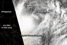 The northwestern Pacific has generated its fourteenth tropical cyclone and NASA's Aqua satellite flew over the eastern side of the storm early on Aug. 26.Tropical Storm Kong-Rey formed from low pressure System 91W. It is located east of the northeast Philippines and bringing the region gusty winds, rains and rough seas today, Aug 26.Aqua passed over Tropical Storm Kong-Rey on Aug. 26 at 0432 UTC/12:32 a.m. EDT as it was strengthening from a tropical depression into a tropical storm. The Moderate Resolution Imaging Spectroradiometer or MODIS instrument aboard Aqua captured a visible image of Kong-Rey that showed a rounded circulation.Although MODIS did not capture any data over the Philippines, Kong-Rey is far enough east of the island nation that most of the storm was in its sights.A tropical cyclone is made up of hundreds of thunderstorms and the MODIS imagery showed strong thunderstorms around the center of circulation that were casting shadows on the lower surrounding thunderstorms. Satellite imagery also revealed banding of thunderstorms was beginning to occur.On Aug. 25 at 1500 UTC/11 a.m. EDT Kong-Rey's maximum sustained winds were near 35 knots/40 mph/55 kph. The storm was centered near 17.7 north and 123.9 east, about 241 nautical miles northeastward of Manila, Philippines, has tracked northwestward at 12 knots/13.8 mph/22.2 kph. Tropical Storm Kong-Rey was bringing rainfall to eastern Luzon.The forecast along the eastern seaboard of Central and Southern Luzon for Aug. 26 calls for cloudy skies with scattered to widespread rain showers and thunderstorms. According to PAGASA, the Phillippine Atmospheric and Astronomical Services Administration, winds in that area area expected to be sustained between 32 and 39 mph/52 and 63 kph/28 to 34 knots/ and seas are expected to be very rough as Kong-Rey continues moving past the northern Philippines.
Kong-Rey is forecast to move northwest and move past Luzon and pass to the east of Taiwan on its northern journey
The northwestern Pacific has generated its fourteenth tropical cyclone and NASA's Aqua satellite flew over the eastern side of the storm early on Aug. 26.Tropical Storm Kong-Rey formed from low pressure System 91W. It is located east of the northeast Philippines and bringing the region gusty winds, rains and rough seas today, Aug 26.Aqua passed over Tropical Storm Kong-Rey on Aug. 26 at 0432 UTC/12:32 a.m. EDT as it was strengthening from a tropical depression into a tropical storm. The Moderate Resolution Imaging Spectroradiometer or MODIS instrument aboard Aqua captured a visible image of Kong-Rey that showed a rounded circulation.Although MODIS did not capture any data over the Philippines, Kong-Rey is far enough east of the island nation that most of the storm was in its sights.A tropical cyclone is made up of hundreds of thunderstorms and the MODIS imagery showed strong thunderstorms around the center of circulation that were casting shadows on the lower surrounding thunderstorms. Satellite imagery also revealed banding of thunderstorms was beginning to occur.On Aug. 25 at 1500 UTC/11 a.m. EDT Kong-Rey's maximum sustained winds were near 35 knots/40 mph/55 kph. The storm was centered near 17.7 north and 123.9 east, about 241 nautical miles northeastward of Manila, Philippines, has tracked northwestward at 12 knots/13.8 mph/22.2 kph. Tropical Storm Kong-Rey was bringing rainfall to eastern Luzon.The forecast along the eastern seaboard of Central and Southern Luzon for Aug. 26 calls for cloudy skies with scattered to widespread rain showers and thunderstorms. According to PAGASA, the Phillippine Atmospheric and Astronomical Services Administration, winds in that area area expected to be sustained between 32 and 39 mph/52 and 63 kph/28 to 34 knots/ and seas are expected to be very rough as Kong-Rey continues moving past the northern Philippines.
Kong-Rey is forecast to move northwest and move past Luzon and pass to the east of Taiwan on its northern journey
NASA Sees Tropical Storm Juliette Waning Near Mexico's Baja California
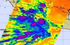 August 29, 2013 brought a lot of tropical activity back to the Eastern Pacific Ocean. Late on Aug. 28, Tropical Storm Juliette formed just west of the coast of Baja California, Mexico, and two other low pressure areas developed south and southeast of the storm. NASA's Aqua satellite captured Juliette and the low pressure areas in infrared imagery.NASA's Aqua satellite passed over the Eastern Pacific Ocean on Aug. 29 at 08:53 UTC/4:53 a.m. EDT, and the Atmospheric Infrared Sounder or AIRS instrument captured an infrared look at the region. AIRS data showed Tropical Storm Juliette near the western coast of the Baja California peninsula. Satellite data shows that only a small area of thunderstorms remained around Juliette's center. Some of the thunderstorms did have very cold cloud top temperatures near -63F/-53C, which is indicative of heavy rainfall.During the morning of Aug. 29, a Tropical Storm Warning was in force for the west coast of the Baja California peninsula, from Puerto San Andresito to Punta Eugenia. Juliette is expected to produce total rainfall amounts of 1 to 3 inches over southern portions of the Baja California Peninsula.
Tropical Storm Juliette formed on Aug. 28 at 5 p.m. EDT from System 95E that had been hugging the western Mexico coast for several days. Juliette was born near 21.5 north and 108.6 west, just 130 miles/205 km southeast of Cabo San Lucas, Mexico and had maximum sustained winds near 45 mph/75 kph.By 11 a.m. EDT/1500 UTC on Aug. 29, Tropical Storm Juliette had maximum sustained winds near 40 mph/65 kph. The National Hurricane Center expects Juliette to weaken later in the day. Juliette was centered near latitude 25.7 north and longitude 113.1 west, just about 80 miles/130 km northwest of Cabo San Lazaro, Mexico. Juliette is moving toward the northwest near 22 mph/35 kph but is expected to slow down later today. The National Hurricane Center expects that Juliette will turn to the west-northwest and slow down on Aug. 30. Juliette's center will keep moving along or near the west coast of the Baja California Peninsula through the evening hours of Aug. 29, and weakening because it continues to interact with the coast, and is moving into cooler waters. Juliette is forecast to become a remnant low tonight or Friday.There are two other low pressure areas in the Eastern Pacific, but they are expected to be slow to develop.The first low pressure area is located about 800 mile south-southwest of the southern tip of Baja California. It's a broad area of low pressure that is generating a large area of clouds and some showers. AIRS data showed that there were some thunderstorms in this low capable of dropping heavy rainfall. Some storms had very cold cloud top temperatures near -63F/-53C which tells scientists that the thunderstorms were extending high into the troposphere. That low is moving to the northeast or north-northeast at 10 mph. It has a 10 percent chance for development for the next day or two, before it reaches cooler waters.
The second low pressure area lies to the west of the first low. That low is located 1,500 miles west-southwest of the southern tip of the Baja California peninsula, and satellite data showed that shower activity decreased from the previous day. This low is moving northward and has a 20 percent chance of development in the next two days, according to the National Hurricane Center.
August 29, 2013 brought a lot of tropical activity back to the Eastern Pacific Ocean. Late on Aug. 28, Tropical Storm Juliette formed just west of the coast of Baja California, Mexico, and two other low pressure areas developed south and southeast of the storm. NASA's Aqua satellite captured Juliette and the low pressure areas in infrared imagery.NASA's Aqua satellite passed over the Eastern Pacific Ocean on Aug. 29 at 08:53 UTC/4:53 a.m. EDT, and the Atmospheric Infrared Sounder or AIRS instrument captured an infrared look at the region. AIRS data showed Tropical Storm Juliette near the western coast of the Baja California peninsula. Satellite data shows that only a small area of thunderstorms remained around Juliette's center. Some of the thunderstorms did have very cold cloud top temperatures near -63F/-53C, which is indicative of heavy rainfall.During the morning of Aug. 29, a Tropical Storm Warning was in force for the west coast of the Baja California peninsula, from Puerto San Andresito to Punta Eugenia. Juliette is expected to produce total rainfall amounts of 1 to 3 inches over southern portions of the Baja California Peninsula.
Tropical Storm Juliette formed on Aug. 28 at 5 p.m. EDT from System 95E that had been hugging the western Mexico coast for several days. Juliette was born near 21.5 north and 108.6 west, just 130 miles/205 km southeast of Cabo San Lucas, Mexico and had maximum sustained winds near 45 mph/75 kph.By 11 a.m. EDT/1500 UTC on Aug. 29, Tropical Storm Juliette had maximum sustained winds near 40 mph/65 kph. The National Hurricane Center expects Juliette to weaken later in the day. Juliette was centered near latitude 25.7 north and longitude 113.1 west, just about 80 miles/130 km northwest of Cabo San Lazaro, Mexico. Juliette is moving toward the northwest near 22 mph/35 kph but is expected to slow down later today. The National Hurricane Center expects that Juliette will turn to the west-northwest and slow down on Aug. 30. Juliette's center will keep moving along or near the west coast of the Baja California Peninsula through the evening hours of Aug. 29, and weakening because it continues to interact with the coast, and is moving into cooler waters. Juliette is forecast to become a remnant low tonight or Friday.There are two other low pressure areas in the Eastern Pacific, but they are expected to be slow to develop.The first low pressure area is located about 800 mile south-southwest of the southern tip of Baja California. It's a broad area of low pressure that is generating a large area of clouds and some showers. AIRS data showed that there were some thunderstorms in this low capable of dropping heavy rainfall. Some storms had very cold cloud top temperatures near -63F/-53C which tells scientists that the thunderstorms were extending high into the troposphere. That low is moving to the northeast or north-northeast at 10 mph. It has a 10 percent chance for development for the next day or two, before it reaches cooler waters.
The second low pressure area lies to the west of the first low. That low is located 1,500 miles west-southwest of the southern tip of the Baja California peninsula, and satellite data showed that shower activity decreased from the previous day. This low is moving northward and has a 20 percent chance of development in the next two days, according to the National Hurricane Center.
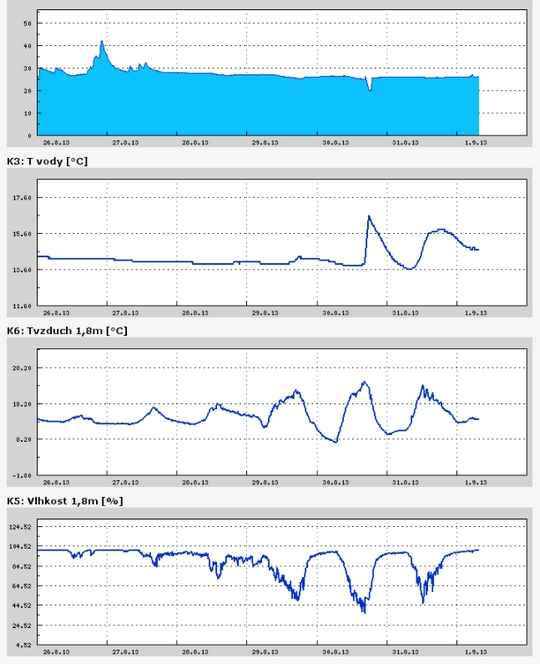
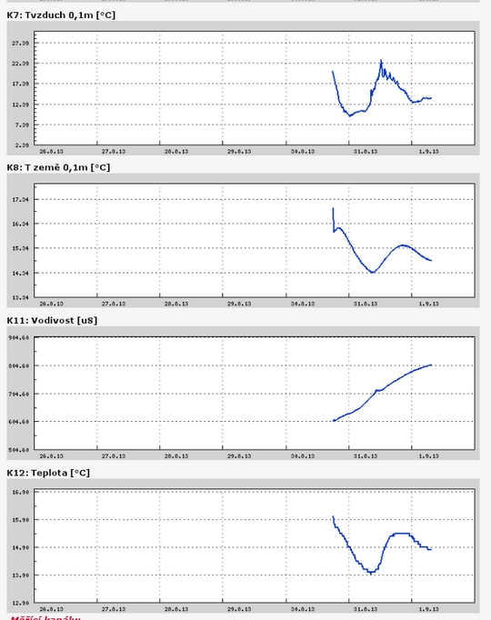
Teplota vzduchu a vody, vlhkost ,
 https://stanice.fiedler-magr.cz
Archiv
28_201327_2013
26_2013
25_2013
24_2013
23_2013
22_2013
21_2013
20_2013
19_2013
18_2013
17_2013
16_2013
15_2013
14_2013
13_2013
12_2013
11_2013
10_2013
09_2013
08_2013
07_2013
06_2013
05_2013
04_2013
03_2013
02_2013
01_2013

 | Zemědělská 1/1665 613 00 Brno Budova D | Tel.: +420 545 133 350 Fax.: +420 545 212 044 |  |
 |