

Učit se znamená objevovat to, co už víš.
Konat znamená demonstrovat, že to to víš.
Učit druhé znamená připomínat jim, že to vědí stejně dobře jako ty.
Všichni jste zároveň žáci, praktikanti a učitelé.
Richard Bach
Konference
Konference v roce 2015
Konference v roce 2014
Konference v roce 2013
Konference v roce 2012
Konference v roce 2011


Polní laboratoř
Calm Skies Over Three Oceans
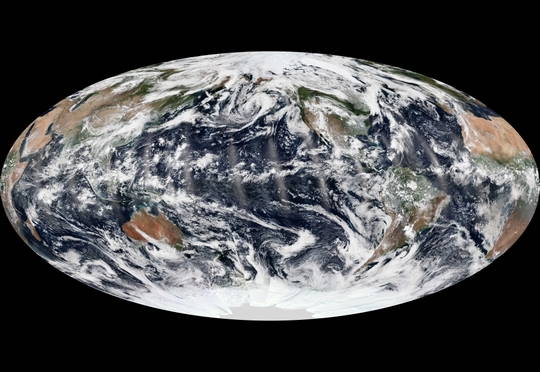 We live on a dynamic, restless planet. On any given day, there is usually a cyclone, tropical depression, or extra-tropical storm brewing somewhere on the Earth. But for a brief moment this week, the skies over all of the oceans were relatively calm. The image above is a composite of fourteen polar satellite passes, or swaths, stitched together from September 8, 2013. The natural-color images were acquired by the Visible Infrared Imaging Radiometer Suite (VIIRS) on the Suomi National Polar-orbiting Partnership (Suomi NPP) satellite. At the time of those near-midday passes, there were no hurricanes, cyclones, or tropical storms in the Atlantic, Pacific, or Indian Ocean basins—a relatively rare occurrence at the height of the hurricane/cyclone season in the northern hemisphere. There was plenty of cloud cover, of course, and smaller storm systems. In the eastern Pacific, remnants of tropical storm Lorena were breaking up near the Baja Peninsula. In the eastern Atlantic, the pieces of tropical depression #9 were starting to gather near the islands of Cape Verde; by the next day, tropical storm Humberto would form. In its May and August 2013 outlooks, the National Hurricane Center forecasted a 70 percent chance of a “more active than normal” season, with 13 to 20 named storms and 7 to 11 hurricanes. A “normal” season typically produces 12 named storms, including 6 hurricanes. Through the second week of September (the midpoint of the Atlantic hurricane season), there have been nine named storms—keeping pace with predictions—but just one that reached hurricane strength. The one hurricane, Humberto, was observed on September 11, 2013, by the Moderate Resolution Imaging Spectroradiometer (MODIS) on NASA’s Terra satellite. Humberto became a hurricane around 5 a.m. on September 11, just hours short of becoming the latest date for the first hurricane in a season.
By September 13, Humberto had weakened to a tropical storm. Forecasts were calling for the northwest-moving storm to reach hurricane status again by September 19, when it will be in the middle of the Atlantic Ocean and well away from land.The slow start does not necessarily mean the hurricane season will be mild. “What happens in the early part of the season is generally not a good predictor of the second half of the season, which is when the majority of hurricanes and major hurricanes form,” said Gerry Bell, lead seasonal hurricane forecaster for the National Oceanic and Atmospheric Administration. “NOAA’s outlooks are for the season as a whole, and not for any particular month during the season.” In the period from 1981 to 2010, the Atlantic basin has averaged six hurricanes per year, and 61 percent of all Atlantic named storms form from September through November. “The 2013 hurricane season was billed as a stud, but up through mid-September, it has been a dud,” said Bill Patzert, climatologist at NASA’s Jet Propulsion Laboratory. “Stay vigilant, though. Hurricanes could be late and active. Remember hurricane Sandy in late October last year.” Image Credit: NASA Earth Observatory image by Jesse Allen, using VIIRS data from the Suomi National Polar-orbiting Partnership. Suomi NPP is the result of a partnership between NASA, the National Oceanic and Atmospheric Administration, and the Department of Defense. Caption Credit: Michael Carlowicz. Instrument: Suomi NPP – VIIRS
NASA Spots Wide Band of Strong Thunderstorms South of Tropical Storm Usagi's Center
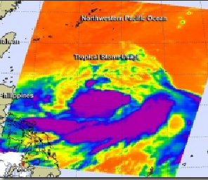 The AIRS instrument aboard NASA's Aqua satellite captured this infrared image of Tropical Storm Usagi on Sept. 16 at 16:59 UTC/12:59 a.m. EDT. The image showed the highest storms and coldest cloud top temperatures (purple) around and south of the center. Infrared data provides a look at cloud top temperatures in tropical cyclones and there were very cold cloud tops in the thunderstorms banding around the south of newborn Tropical Storm Usagi's Center.On Sept. 16, low pressure System 99W strengthened into Tropical Depression 17W. The depression became Tropical Storm Usagi very late in the day.The Atmospheric Infrared Sounder or AIRS instrument aboard NASA's Aqua satellite captured an infrared image of Tropical Storm Usagi on Sept. 16 at 16:59 UTC/12:59 a.m. EDT. The image showed the highest storms and coldest cloud top temperatures around and south of the center of circulation. The cloud top temperatures exceeded -63F/-52C in those areas, indicating high thunderstorms, with the potential for heavy rainfall.The Joint Typhoon Warning Center or JTWC is the forecast organization for this tropical storm. JTWC noted that animated infrared satellite imagery revealed the low-level circulation center was consolidating, although partially exposed to outside winds. The circulation center has become more tightly wrapped and a central dense overcast feature has started to build along the southern edge of the center.
When NASA's Tropical Rainfall Measuring Mission satellite called TRMM passed overhead on Sept. 17 at 1050 UTC/6:50 a.m. EDT, the TRMM Microwave Imager, or TMI showed that the low-level center was continuing to consolidate and wrap more tightly, while thunderstorms and convection continued to strengthen.On Tuesday, Sept. 17 at 1500 UTC/11 a.m. EDT Usagi had maximum sustained winds near 40 knots//46 mph/74 kph. Usagi was centered near 17.6 north and 130.6 east, about 559 nautical miles/643 miles/1,035 km south-southeast of Kadena Air Base. Usagi was moving to the west at 5 knots/5.7 mph/9.2 kph.The Joint Typhoon Warning Center forecast takes Usagi west toward the northern Philippines but turning to the northwest before reaching the country, and heading toward Taiwan
The AIRS instrument aboard NASA's Aqua satellite captured this infrared image of Tropical Storm Usagi on Sept. 16 at 16:59 UTC/12:59 a.m. EDT. The image showed the highest storms and coldest cloud top temperatures (purple) around and south of the center. Infrared data provides a look at cloud top temperatures in tropical cyclones and there were very cold cloud tops in the thunderstorms banding around the south of newborn Tropical Storm Usagi's Center.On Sept. 16, low pressure System 99W strengthened into Tropical Depression 17W. The depression became Tropical Storm Usagi very late in the day.The Atmospheric Infrared Sounder or AIRS instrument aboard NASA's Aqua satellite captured an infrared image of Tropical Storm Usagi on Sept. 16 at 16:59 UTC/12:59 a.m. EDT. The image showed the highest storms and coldest cloud top temperatures around and south of the center of circulation. The cloud top temperatures exceeded -63F/-52C in those areas, indicating high thunderstorms, with the potential for heavy rainfall.The Joint Typhoon Warning Center or JTWC is the forecast organization for this tropical storm. JTWC noted that animated infrared satellite imagery revealed the low-level circulation center was consolidating, although partially exposed to outside winds. The circulation center has become more tightly wrapped and a central dense overcast feature has started to build along the southern edge of the center.
When NASA's Tropical Rainfall Measuring Mission satellite called TRMM passed overhead on Sept. 17 at 1050 UTC/6:50 a.m. EDT, the TRMM Microwave Imager, or TMI showed that the low-level center was continuing to consolidate and wrap more tightly, while thunderstorms and convection continued to strengthen.On Tuesday, Sept. 17 at 1500 UTC/11 a.m. EDT Usagi had maximum sustained winds near 40 knots//46 mph/74 kph. Usagi was centered near 17.6 north and 130.6 east, about 559 nautical miles/643 miles/1,035 km south-southeast of Kadena Air Base. Usagi was moving to the west at 5 knots/5.7 mph/9.2 kph.The Joint Typhoon Warning Center forecast takes Usagi west toward the northern Philippines but turning to the northwest before reaching the country, and heading toward Taiwan
NASA Sees Formation of Northwestern Pacific's Tropical Depression 18W
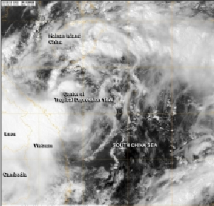 NASA's Aqua satellite caught the birth of the eighteenth tropical depression of the northwestern Pacific Ocean tropical cyclone season on Sept. 18 at 0616 UTC/2:16 a.m. EDT. NASA's Aqua satellite caught the birth of the eighteenth tropical depression of the northwestern Pacific Ocean tropical cyclone season. Tropical Depression 18W was born in the South China Sea and is expected to be short-lived after a quick landfall in central Vietnam.The Moderate Resolution Imaging Spectroradiometer instrument aboard NASA's Aqua satellite captured a visible image of disorganized Tropical Depression 18W on Sept. 18 at 0616 UTC/2:16 a.m. EDT. Satellite imagery showed that the circulation is large, and that convection and thunderstorms appear disorganized on the northern and western edges of the storm.
On Sept. 18 at 0900 UTC/5 a.m. EDT, Tropical Depression 18W had maximum sustained winds near 25 knots. It was located just 125 nautical miles east-northeast of Da Nang, Vietnam, near 16.5 north and 109.9 east over the South China Sea. It was moving to the west-northwest at 7 knots.TD18W is expected to make landfall in central Vietnam on Sept. 19, just south of Hue. It is then expected to continue moving west-southwest and is expected to dissipate within a day after making landfall.
NASA's Aqua satellite caught the birth of the eighteenth tropical depression of the northwestern Pacific Ocean tropical cyclone season on Sept. 18 at 0616 UTC/2:16 a.m. EDT. NASA's Aqua satellite caught the birth of the eighteenth tropical depression of the northwestern Pacific Ocean tropical cyclone season. Tropical Depression 18W was born in the South China Sea and is expected to be short-lived after a quick landfall in central Vietnam.The Moderate Resolution Imaging Spectroradiometer instrument aboard NASA's Aqua satellite captured a visible image of disorganized Tropical Depression 18W on Sept. 18 at 0616 UTC/2:16 a.m. EDT. Satellite imagery showed that the circulation is large, and that convection and thunderstorms appear disorganized on the northern and western edges of the storm.
On Sept. 18 at 0900 UTC/5 a.m. EDT, Tropical Depression 18W had maximum sustained winds near 25 knots. It was located just 125 nautical miles east-northeast of Da Nang, Vietnam, near 16.5 north and 109.9 east over the South China Sea. It was moving to the west-northwest at 7 knots.TD18W is expected to make landfall in central Vietnam on Sept. 19, just south of Hue. It is then expected to continue moving west-southwest and is expected to dissipate within a day after making landfall.
TRMM Satellite Sees System 98W Organizing Near Guam, Marianas
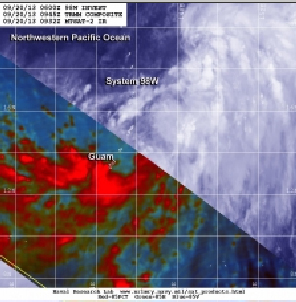 NASA's TRMM satellite data was combined with infrared imagery from Japan's MTSAT-2 to provide a better picture of the low pressure area and showed that heavy rainfall was occurring over Guam at 0945 UTC.
NASA's TRMM satellite data revealed heavy rainfall and banding of thunderstorms around the southern quadrant of System 98W in the northwestern Pacific near Guam and the Marianas Islands. Those are two signs that the low pressure area may be consolidating into a tropical depression.
At 1700 UTC/1 p.m. EDT on Sept. 20, System 98W was centered about 16.2 north and 146.7 east, about 195 nautical miles north-northeast of Andersen Air Force Base, Guam. System 98W had maximum sustained winds near 25 knots/28.7 mph/46.3 kph.
NASA's Tropical Rainfall Measuring Mission satellite called TRMM passed over System 98W earlier in the day and observed its rainfall.At the Naval Research Laboratory, NASA's TRMM satellite data was combined with infrared imagery from Japan's MTSAT-2 to provide a better picture of the low pressure area. The TRMM data showed that heavy rainfall was occurring over Guam at 0945 UTC/5:45 a.m. EDT.Later on Sept. 20, at 3 p.m. EDT, Guam International Airport was still reporting heavy rain, and fog/mist and a temperature of 79F. Winds were blowing from the southwest at 14 mph/22.5 kph, gusting to 18 mph/28/9.
Infrared satellite imagery showed strong convection northeast of the center of circulation and convective banding of thunderstorms southwest of the center. Those thunderstorms in the southwestern bands were affecting Guam. The Joint Typhoon Warning Center noted that strong vertical wind shear is appearing in the upper-levels of the atmosphere near System 98W. In fact, northeasterly winds are blowing at 30 knots/34.5 mph/55.5 kph. Wind shear can weaken a storm and even tear it apart, and there's even moderate wind shear of up to 20 knots/23 mph/37 kph happening in the storm's center.The National Weather Service in Guam issued the following bulletin at 12 a.m. CHST on Saturday, Sept. 21, 2013 local time: A tropical disturbance continues to develop in the vicinity of the Marianas. Satellite and radar imagery indicate the heaviest rain associated with the tropical disturbance has shifted to the south and east of the Marianas. However...a brief heavy shower is still possible through Saturday. The latest computer models indicate that much of the weekend will be markedly drier than the past few days. The potential for heavy rainfall will return late Sunday into Monday as this system develops and moves northward. Light to gentle winds tonight will become southwest and increase to 25 to 30 mph by Saturday night as the disturbance moves northward. Offshore seas of 8 to 10 feet tonight will steadily increase to between 11 and 13 feet by Monday as southwest winds increase across the Marianas over the next few days. Because the low-level center is consolidating the Joint Typhoon Warning Center expects System 98W to become a tropical depression in the next 24 hours. System 98W has been moving to the north and is expected to continue moving in that direction over the next two days.
NASA's TRMM satellite data was combined with infrared imagery from Japan's MTSAT-2 to provide a better picture of the low pressure area and showed that heavy rainfall was occurring over Guam at 0945 UTC.
NASA's TRMM satellite data revealed heavy rainfall and banding of thunderstorms around the southern quadrant of System 98W in the northwestern Pacific near Guam and the Marianas Islands. Those are two signs that the low pressure area may be consolidating into a tropical depression.
At 1700 UTC/1 p.m. EDT on Sept. 20, System 98W was centered about 16.2 north and 146.7 east, about 195 nautical miles north-northeast of Andersen Air Force Base, Guam. System 98W had maximum sustained winds near 25 knots/28.7 mph/46.3 kph.
NASA's Tropical Rainfall Measuring Mission satellite called TRMM passed over System 98W earlier in the day and observed its rainfall.At the Naval Research Laboratory, NASA's TRMM satellite data was combined with infrared imagery from Japan's MTSAT-2 to provide a better picture of the low pressure area. The TRMM data showed that heavy rainfall was occurring over Guam at 0945 UTC/5:45 a.m. EDT.Later on Sept. 20, at 3 p.m. EDT, Guam International Airport was still reporting heavy rain, and fog/mist and a temperature of 79F. Winds were blowing from the southwest at 14 mph/22.5 kph, gusting to 18 mph/28/9.
Infrared satellite imagery showed strong convection northeast of the center of circulation and convective banding of thunderstorms southwest of the center. Those thunderstorms in the southwestern bands were affecting Guam. The Joint Typhoon Warning Center noted that strong vertical wind shear is appearing in the upper-levels of the atmosphere near System 98W. In fact, northeasterly winds are blowing at 30 knots/34.5 mph/55.5 kph. Wind shear can weaken a storm and even tear it apart, and there's even moderate wind shear of up to 20 knots/23 mph/37 kph happening in the storm's center.The National Weather Service in Guam issued the following bulletin at 12 a.m. CHST on Saturday, Sept. 21, 2013 local time: A tropical disturbance continues to develop in the vicinity of the Marianas. Satellite and radar imagery indicate the heaviest rain associated with the tropical disturbance has shifted to the south and east of the Marianas. However...a brief heavy shower is still possible through Saturday. The latest computer models indicate that much of the weekend will be markedly drier than the past few days. The potential for heavy rainfall will return late Sunday into Monday as this system develops and moves northward. Light to gentle winds tonight will become southwest and increase to 25 to 30 mph by Saturday night as the disturbance moves northward. Offshore seas of 8 to 10 feet tonight will steadily increase to between 11 and 13 feet by Monday as southwest winds increase across the Marianas over the next few days. Because the low-level center is consolidating the Joint Typhoon Warning Center expects System 98W to become a tropical depression in the next 24 hours. System 98W has been moving to the north and is expected to continue moving in that direction over the next two days.
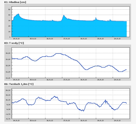
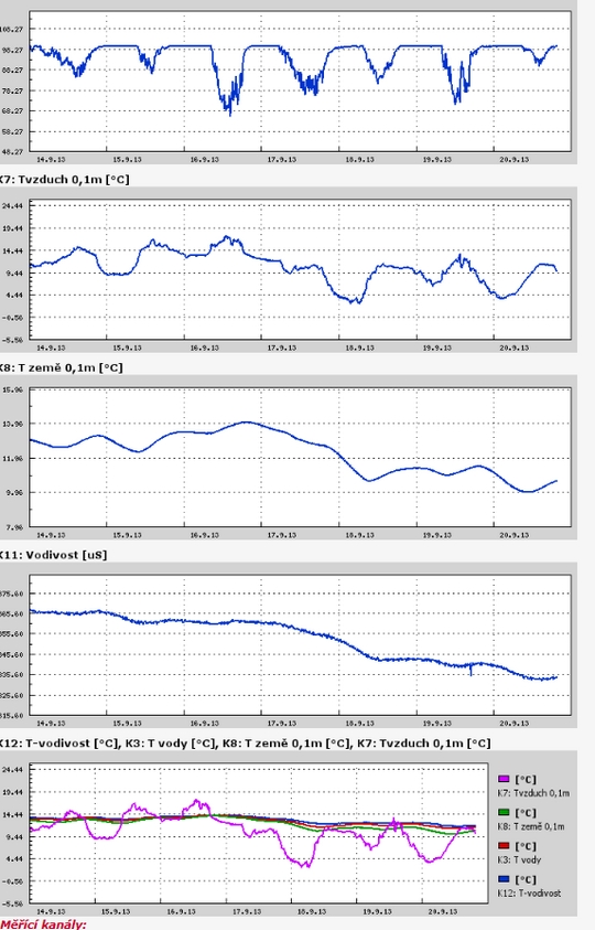
Teplota vzduchu a vody, vlhkost ,
 https://stanice.fiedler-magr.cz
Archiv
30_201329_2013
28_2013
27_2013
26_2013
25_2013
24_2013
23_2013
22_2013
21_2013
20_2013
19_2013
18_2013
17_2013
16_2013
15_2013
14_2013
13_2013
12_2013
11_2013
10_2013
09_2013
08_2013
07_2013
06_2013
05_2013
04_2013
03_2013
02_2013
01_2013

 | Zemědělská 1/1665 613 00 Brno Budova D | Tel.: +420 545 133 350 Fax.: +420 545 212 044 |  |
 |