

Tajemství vládnutí spočívá totiž v tom, jak spojit víru ve vlastní neomylnost se schopností učit se z minulých chyb.
George Orwell
Konference
Konference v roce 2015
Konference v roce 2014
Konference v roce 2013
Konference v roce 2012
Konference v roce 2011


Polní laboratoř
Satellite Sees Wutip in North Pacific Ocean: a New Tropical Storm
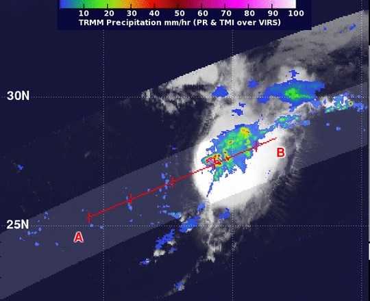 Tropical Depression 11 formed in the central Atlantic Ocean and NASA's TRMM satellite passed overhead and gathered information and identified a "hot tower" that indicated it would strengthen. The depression became Tropical Storm Jerry on Sept. 30 at 10:30 a.m. EDT. The eleventh Atlantic tropical depression formed around 11 p.m. EDT on Saturday, Sept. 28, about 960 miles/1,540 km east-northeast of the Leeward Islands and was moving north at 9 mph. When NASA's TRMM or Tropical Rainfall Measuring Mission satellite flew over Tropical Depression 11 on Sept. 30 at 09:28 UTC/5:28 a.m. EDT. TRMM observed a "hot tower" or towering thunderstorm near the center of circulation, where the cloud top exceeded 16 km/9.9 miles high. Rainfall in that storm was also falling at a rate of over 2 inches/50 mm per hour. A "hot tower" is a tall cumulonimbus cloud that reaches at least to the top of the troposphere, the lowest layer of the atmosphere. It extends approximately nine miles (14.5 km) high in the tropics.
The hot towers in Tropical Depression 11 were reaching heights of 16 km/9.9 miles high around the depression's center. These towers are called "hot" because they rise to such altitude due to the large amount of latent heat. Water vapor releases this latent heat as it condenses into liquid. NASA research shows that a tropical cyclone with a hot tower in its eye wall was twice as likely to intensify within six or more hours, than a cyclone that lacked a hot tower. Those hot towers also drop heavy rainfall. By 10:30 a.m. EDT just 5 hours after NASA's TRMM satellite spotted the "hot tower" in Tropical Depression 11, it strengthened into Tropical Storm Jerry. Jerry had maximum sustained winds near 40 mph/65 kph. It was moving to the east at 7 mph/11 kph and is expected to move slowly and erratically over the next several days. Jerry was centered about 1,200 miles/1,935 km east-southeast of Bermuda. It had a minimum central pressure of 1008 millibars. The National Hurricane Center expects that Jerry will experience some strengthening over the next day or two. For addition forecast updates, visit the National Hurricane Center website at: www.nhc.noaa.gov
Infrared NASA Imagery Shows Some Strength in Tropical Depression Sepat
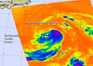 Tropical Depression Sepat formed in the northwestern Pacific Ocean and NASA's Aqua satellite captured infrared data on the storm, revealing some strong thunderstorms.
Tropical Depression Sepat, the twenty-first tropical depression in the northwestern Pacific Ocean, formed on Sept. 30. NASA's Aqua satellite passed over Sepat on Sept. 30 at 03:23 UTC/Sept. 29 at 11:23 p.m. EDT. As Aqua passed overhead, that Atmospheric Infrared Sounder or AIRS instrument that flies aboard Aqua looked at the storm in infrared light. The AIRS data showed some cold cloud tops of thunderstorms near the center of circulation that were as cold as -63F/-52C indicating some strength in the system.
Satellite imagery also showed that the low-level center remained tightly wrapped, despite weak convective (rising air that forms the thunderstorms that make up a tropical cyclone) organization. Sepat, however is battling moderate wind shear and is expected to track over a pool of cooler waters north of the islands of Iwo To, Japan, which is expected to hinder its development.
On Sept. 30 at 1500 UTC/11 a.m. EDT Tropical Depression Sepat had maximum sustained winds near 30 knots/34.5 mph/55.5 kph. It was centered near 28.3 north and 143.3 east, about 485 nautical miles south-southeast of Yokosuka, Japan. It was moving to the northwest, but is expected to turn to the northeast. For additional information, visit the JointTyphoon Warning Center website at:
Tropical Depression Sepat formed in the northwestern Pacific Ocean and NASA's Aqua satellite captured infrared data on the storm, revealing some strong thunderstorms.
Tropical Depression Sepat, the twenty-first tropical depression in the northwestern Pacific Ocean, formed on Sept. 30. NASA's Aqua satellite passed over Sepat on Sept. 30 at 03:23 UTC/Sept. 29 at 11:23 p.m. EDT. As Aqua passed overhead, that Atmospheric Infrared Sounder or AIRS instrument that flies aboard Aqua looked at the storm in infrared light. The AIRS data showed some cold cloud tops of thunderstorms near the center of circulation that were as cold as -63F/-52C indicating some strength in the system.
Satellite imagery also showed that the low-level center remained tightly wrapped, despite weak convective (rising air that forms the thunderstorms that make up a tropical cyclone) organization. Sepat, however is battling moderate wind shear and is expected to track over a pool of cooler waters north of the islands of Iwo To, Japan, which is expected to hinder its development.
On Sept. 30 at 1500 UTC/11 a.m. EDT Tropical Depression Sepat had maximum sustained winds near 30 knots/34.5 mph/55.5 kph. It was centered near 28.3 north and 143.3 east, about 485 nautical miles south-southeast of Yokosuka, Japan. It was moving to the northwest, but is expected to turn to the northeast. For additional information, visit the JointTyphoon Warning Center website at:
http://www.usno.navy.mil/JTWC/ The Joint Typhoon Warning Center or JTWC expects Sepat to briefly strengthen into a tropical storm on Oct. 1 before weakening again to a depression and becoming extra-tropical as it parallels Japan's east coast on a northeastern track. The JTWC expects Sepat's western edge to graze eastern coastal Japan as it moves into the northern reaches of the northwestern Pacific Ocean.
NASA Sees Tropical Depression 22W Taking a Northern Route in Northwestern Pacific
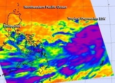 NASA's Aqua satellite gathered infrared data on Tropical Depression 22W on Sept. 30 at 12:59 a.m. EDT and saw some strong thunderstorms in the northern and southern quadrants (purple).
The twenty-first and twenty-second tropical depressions of the northwestern Pacific Ocean formed on Sept. 30 and while one is headed to the northeast, the other is headed to the northwest.
Tropical Depression 21W also known as Sepat is forecast to turn to the northeast and parallel the coast of eastern Japan, while staying far off-shore. Tropical Depression 22W, however, is taking a different route and heading to the northwest.
The Atmospheric Infrared Sounder or AIRS instrument that flies aboard NASA's Aqua satellite gathered infrared data on Sept. 30 at 04:59 UTC/12:59 a.m. EDT when it passed over the depression. Some of the thunderstorms in the northern and southern quadrant showed deep/strong convection (rising air that form thunderstorms that make up tropical cyclones).
Satellite data on Sept. 30 showed that the low-level circulation center is consolidating and that banding of thunderstorms were strengthening and organizing along the northern and southern quadrants were starting to wrap tighter into the low-level center.
On Sept. 30 at 1200 UTC/8 a.m. EDT, maximum sustained winds were near 30 knots/34.5 mph/55.5 kph. TD 22W was centered near 28.3 north and 143.3. east, about 485 nautical miles south-southeast of Yokosuka, Japan and 398 nautical miles north-northwest of Koror, Palau. TD22W was moving to the northwest at 15 knots/17.2 mph/27.7 kph. For additional updates, visit: http://www.usno.navy.mil/JTWC/.
The Joint Typhoon Warning Center noted that Tropical Depression 22W will be dealing with favorable environmental conditions over the next several days: good outflow, low vertical wind shear and warm sea surface temperatures. All of those factors will allow the depression to strengthen into a typhoon in the next two days on its trek north.
In three days, a mid-latitude trough of low pressure is expected to move over Japan which will allow a subtropical ridge (elongated area) of high pressure to develop south of Japan and push the depression to the northwest.
NASA's Aqua satellite gathered infrared data on Tropical Depression 22W on Sept. 30 at 12:59 a.m. EDT and saw some strong thunderstorms in the northern and southern quadrants (purple).
The twenty-first and twenty-second tropical depressions of the northwestern Pacific Ocean formed on Sept. 30 and while one is headed to the northeast, the other is headed to the northwest.
Tropical Depression 21W also known as Sepat is forecast to turn to the northeast and parallel the coast of eastern Japan, while staying far off-shore. Tropical Depression 22W, however, is taking a different route and heading to the northwest.
The Atmospheric Infrared Sounder or AIRS instrument that flies aboard NASA's Aqua satellite gathered infrared data on Sept. 30 at 04:59 UTC/12:59 a.m. EDT when it passed over the depression. Some of the thunderstorms in the northern and southern quadrant showed deep/strong convection (rising air that form thunderstorms that make up tropical cyclones).
Satellite data on Sept. 30 showed that the low-level circulation center is consolidating and that banding of thunderstorms were strengthening and organizing along the northern and southern quadrants were starting to wrap tighter into the low-level center.
On Sept. 30 at 1200 UTC/8 a.m. EDT, maximum sustained winds were near 30 knots/34.5 mph/55.5 kph. TD 22W was centered near 28.3 north and 143.3. east, about 485 nautical miles south-southeast of Yokosuka, Japan and 398 nautical miles north-northwest of Koror, Palau. TD22W was moving to the northwest at 15 knots/17.2 mph/27.7 kph. For additional updates, visit: http://www.usno.navy.mil/JTWC/.
The Joint Typhoon Warning Center noted that Tropical Depression 22W will be dealing with favorable environmental conditions over the next several days: good outflow, low vertical wind shear and warm sea surface temperatures. All of those factors will allow the depression to strengthen into a typhoon in the next two days on its trek north.
In three days, a mid-latitude trough of low pressure is expected to move over Japan which will allow a subtropical ridge (elongated area) of high pressure to develop south of Japan and push the depression to the northwest.
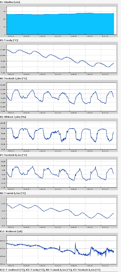
Teplota vzduchu a vody, vlhkost ,
 https://stanice.fiedler-magr.cz
Archiv
33_201332_2013
31_2013
30_2013
29_2013
28_2013
27_2013
26_2013
25_2013
24_2013
23_2013
22_2013
21_2013
20_2013
19_2013
18_2013
17_2013
16_2013
15_2013
14_2013
13_2013
12_2013
11_2013
10_2013
09_2013
08_2013
07_2013
06_2013
05_2013
04_2013
03_2013
02_2013
01_2013

 | Zemědělská 1/1665 613 00 Brno Budova D | Tel.: +420 545 133 350 Fax.: +420 545 212 044 |  |
 |