

Důkazem vysokého vzdělání je schopnost mluvit o největších věcech nejjednodušším způsobem.
David Hume
Konference
Konference v roce 2015
Konference v roce 2014
Konference v roce 2013
Konference v roce 2012
Konference v roce 2011


Polní laboratoř
NASA Investigates Gabrielle's Remnants and New Tropical Storm Humberto
 Tropical Depression Nine formed yesterday, Sept. 8 in the far eastern Atlantic, and NASA's Aqua satellite saw it strengthen into Tropical Storm Humberto today, Sept. 9 at 5 a.m. EDT. As that storm strengthened, the remnants of the once-tropical-storm Gabrielle continued to struggle near the Bahamas as NASA's HS3 mission investigated.
Tropical Storm Humberto is affecting the Cape Verde Islands, so there's a tropical storm warning in up for the southern islands of Maio, Santiago, Fogo, and Brava.
NASA's Aqua satellite passed over Tropical Storm Humberto hours before it was designated a tropical storm, and the Atmospheric Infrared Sounder instrument called "AIRS" captured infrared data on the storm. The AIRS data showed that some strong thunderstorms had developed around the center of circulation that were acting as a "heat engine" for the storm and strengthening it. Cloud-top temperatures of those powerful thunderstorms were colder than -63F/-52C, and forecasters at the National Hurricane Center expect Humberto to continue strengthening in the short term. The image also showed that the most powerful thunderstorms, the ones with the coldest cloud top temperatures, were just south of the Cape Verde Islands at the time Aqua flew overhead. Humberto has since moved closer to some of the southern islands bringing rain and gusty winds today.
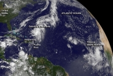
Both Tropical Humberto the remnants of Gabrielle, located on the other side of the Atlantic, were captured in an image from NOAA's GOES-East satellite today. The image, created by the NASA GOES Project at the NASA Goddard Space Flight Center in Greenbelt, Md. showed how far east Humberto is compared to Gabrielle's remnants.
Tropical Depression Nine formed yesterday, Sept. 8 in the far eastern Atlantic, and NASA's Aqua satellite saw it strengthen into Tropical Storm Humberto today, Sept. 9 at 5 a.m. EDT. As that storm strengthened, the remnants of the once-tropical-storm Gabrielle continued to struggle near the Bahamas as NASA's HS3 mission investigated.
Tropical Storm Humberto is affecting the Cape Verde Islands, so there's a tropical storm warning in up for the southern islands of Maio, Santiago, Fogo, and Brava.
NASA's Aqua satellite passed over Tropical Storm Humberto hours before it was designated a tropical storm, and the Atmospheric Infrared Sounder instrument called "AIRS" captured infrared data on the storm. The AIRS data showed that some strong thunderstorms had developed around the center of circulation that were acting as a "heat engine" for the storm and strengthening it. Cloud-top temperatures of those powerful thunderstorms were colder than -63F/-52C, and forecasters at the National Hurricane Center expect Humberto to continue strengthening in the short term. The image also showed that the most powerful thunderstorms, the ones with the coldest cloud top temperatures, were just south of the Cape Verde Islands at the time Aqua flew overhead. Humberto has since moved closer to some of the southern islands bringing rain and gusty winds today.
Both Tropical Humberto the remnants of Gabrielle, located on the other side of the Atlantic, were captured in an image from NOAA's GOES-East satellite today. The image, created by the NASA GOES Project at the NASA Goddard Space Flight Center in Greenbelt, Md. showed how far east Humberto is compared to Gabrielle's remnants.
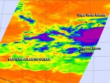 NASA's Aqua satellite passed over Humberto on Sept. 9 and detected cloud-top temperatures of powerful thunderstorms (purple) that were colder than -63F/-52C.
NASA's Hurricane and Severe Storms Sentinel or HS3 mission gathered data over Gabrielle's remnants over the weekend of Sept. 7 and 8. NASA's Global Hawk 872, or NASA 872 departed from NASA's Wallops Flight Facility, Wallops Island, Va. on Saturday, Sept. 7 at 8:07 a.m. EDT and flew over the remnants of Gabrielle as it lingered north of the Dominican Republic. NASA 872 dropped dropsondes and took various measurements of the remnants during its flight.NASA 872 ended flight upon landing back at NASA's Wallops Flight Facility, Wallops Island, Va. on Sunday, Sept. 9 at 7:17 a.m. EDT.
At 8 a.m. on Sept. 9 the center of Tropical Storm Humberto was located near latitude 13.4 north, longitude 23.3 west, just 92 nautical miles south of Praia, in the Cape Verde Islands. Humberto is moving toward the west near 12 mph/19 kph, and the storm is expected to turn to the west-northwest. Maximum sustained winds are near 40 mph/65 kph and is expected to briefly become a hurricane over the next day or two before weakening again.
The National Hurricane Center noted that the center of Humberto will pass south of the southern Cape Verde Islands this afternoon and tonight and pass west of the islands on Tuesday, Sept. 10.
Meanwhile, an elongated area of low pressure that include the remnants of tropical depression Gabrielle are still lingering in the western Atlantic. That broad area of low pressure is located about 500 miles south-southwest of Bermuda. Because of wind shear on Sept. 9, the shower and thunderstorm activity remains displaced to the east of the center as it was on Sunday, Sept. 8. Upper-level winds are not expected to be conducive for significant development while the low moves northeastward to north-northeastward during the next several days. This system has a low chance, 10 percent, of becoming a tropical cyclone during the next two days
Farther west, the National Hurricane Center noted that a low pressure area could form over the Bay of Campeche in the southwestern Gulf of Mexico in the next couple of days.
NASA's Aqua satellite passed over Humberto on Sept. 9 and detected cloud-top temperatures of powerful thunderstorms (purple) that were colder than -63F/-52C.
NASA's Hurricane and Severe Storms Sentinel or HS3 mission gathered data over Gabrielle's remnants over the weekend of Sept. 7 and 8. NASA's Global Hawk 872, or NASA 872 departed from NASA's Wallops Flight Facility, Wallops Island, Va. on Saturday, Sept. 7 at 8:07 a.m. EDT and flew over the remnants of Gabrielle as it lingered north of the Dominican Republic. NASA 872 dropped dropsondes and took various measurements of the remnants during its flight.NASA 872 ended flight upon landing back at NASA's Wallops Flight Facility, Wallops Island, Va. on Sunday, Sept. 9 at 7:17 a.m. EDT.
At 8 a.m. on Sept. 9 the center of Tropical Storm Humberto was located near latitude 13.4 north, longitude 23.3 west, just 92 nautical miles south of Praia, in the Cape Verde Islands. Humberto is moving toward the west near 12 mph/19 kph, and the storm is expected to turn to the west-northwest. Maximum sustained winds are near 40 mph/65 kph and is expected to briefly become a hurricane over the next day or two before weakening again.
The National Hurricane Center noted that the center of Humberto will pass south of the southern Cape Verde Islands this afternoon and tonight and pass west of the islands on Tuesday, Sept. 10.
Meanwhile, an elongated area of low pressure that include the remnants of tropical depression Gabrielle are still lingering in the western Atlantic. That broad area of low pressure is located about 500 miles south-southwest of Bermuda. Because of wind shear on Sept. 9, the shower and thunderstorm activity remains displaced to the east of the center as it was on Sunday, Sept. 8. Upper-level winds are not expected to be conducive for significant development while the low moves northeastward to north-northeastward during the next several days. This system has a low chance, 10 percent, of becoming a tropical cyclone during the next two days
Farther west, the National Hurricane Center noted that a low pressure area could form over the Bay of Campeche in the southwestern Gulf of Mexico in the next couple of days.
NASA Satellite Sees Two Vortices Circling Newborn Tropical Storm Man-yi's Center
 NASA's Terra satellite passed over newborn Tropical Storm Man-yi and captured and image that clearly showed two vortices rotating around a large center of circulation. Man-yi formed on Sept. 12 in the northwestern Pacific Ocean as the sixteenth tropical depression and by Sept. 13 it strengthened into a tropical storm.
When NASA's Terra satellite passed over newborn Tropical Storm Man-yi in the northwestern Pacific Ocean on Sept. 13 at 01:15 UTC, the Moderate Resolution Imaging Spectroradiometer or MODIS instrument captured a visible image of the storm. The MODIS image showed the bulk of clouds and showers on the northwestern and southeastern sides of the storm, but those were associated with the two different vortices or whirling masses of clouds and showers, that are rotating around the storm's actual center. Satellite data showed bands of strong thunderstorms around the southeastern vortex, which is the vortex with the strongest winds. Thunderstorms associated with the northwestern vortex are also strengthening as convection deepens.
Forecasters at the Joint Typhoon Warning Center expect these two different vortices will combine with the larger, broad central circulation, allowing Man-yi to consolidate.
On Sept. 13 at 0900 UTC/5 a.m. EDT, Tropical Storm Man-yi had maximum sustained winds near 35 knots/40.2 mph/64.8 kph. It was moving to the west-northwest at 11 knots/12.6 mph/20.3 kph. Man-yi was centered near 22.5 north and 141.0 east, just 157 nautical miles/180.7 miles/290.8 km south of the island of Iwo To, Japan.
Man-yi is expected to intensify to typhoon strength as it curves from northwest to northeast. On the forecast track issued by the Joint Typhoon Warning Center, Man-yi is expected to approach Tokyo on Sept. 16 as a typhoon.
NASA's Terra satellite passed over newborn Tropical Storm Man-yi and captured and image that clearly showed two vortices rotating around a large center of circulation. Man-yi formed on Sept. 12 in the northwestern Pacific Ocean as the sixteenth tropical depression and by Sept. 13 it strengthened into a tropical storm.
When NASA's Terra satellite passed over newborn Tropical Storm Man-yi in the northwestern Pacific Ocean on Sept. 13 at 01:15 UTC, the Moderate Resolution Imaging Spectroradiometer or MODIS instrument captured a visible image of the storm. The MODIS image showed the bulk of clouds and showers on the northwestern and southeastern sides of the storm, but those were associated with the two different vortices or whirling masses of clouds and showers, that are rotating around the storm's actual center. Satellite data showed bands of strong thunderstorms around the southeastern vortex, which is the vortex with the strongest winds. Thunderstorms associated with the northwestern vortex are also strengthening as convection deepens.
Forecasters at the Joint Typhoon Warning Center expect these two different vortices will combine with the larger, broad central circulation, allowing Man-yi to consolidate.
On Sept. 13 at 0900 UTC/5 a.m. EDT, Tropical Storm Man-yi had maximum sustained winds near 35 knots/40.2 mph/64.8 kph. It was moving to the west-northwest at 11 knots/12.6 mph/20.3 kph. Man-yi was centered near 22.5 north and 141.0 east, just 157 nautical miles/180.7 miles/290.8 km south of the island of Iwo To, Japan.
Man-yi is expected to intensify to typhoon strength as it curves from northwest to northeast. On the forecast track issued by the Joint Typhoon Warning Center, Man-yi is expected to approach Tokyo on Sept. 16 as a typhoon.
NASA Sees System 93L Become Tropical Storm Ingrid, Now Soaking Eastern Mexico
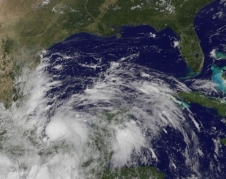 NOAA's GOES-East satellite captured this visible image of Tropical Storm Ingrid at 11:55 a.m. EDT on Sept. 13. Clouds associated with Ingrid covered the Bay of Campeche and strong thunderstorms circled the center of the storm.
NASA and NOAA satellites have been tracking the progression of low pressure System 93L through the Caribbean Sea and into the southwestern Gulf of Mexico over a week's time, and it became Tropical Storm Ingrid mid-day on Sept. 13. NOAA's GOES-East satellite captured an image of Ingrid's center over the Bay of Campeche.
NOAA's GOES-East satellite sits in a fixed orbit and covers weather over the eastern U.S. and Atlantic Ocean, providing imagery continuously. NASA's GOES Project at NASA's Goddard Space Flight Center in Greenbelt, Md. created an image of Tropical Storm Ingrid at 1555 UTC/11:55 a.m. EDT, less than one hour after it was named. The image showed that clouds associated with Ingrid covered the Bay of Campeche, located in the southwestern Gulf of Mexico. Strong thunderstorms circled the center of the storm and the storm is expected to move slowly along the coast while its center stays over water over the next couple of days, bringing large amounts of rainfall to eastern Mexico.
System 93L strengthened into the tenth tropical depression of the Atlantic Ocean season and by 11 a.m. EDT, strengthened further to become the ninth tropical storm. Tropical Depression Eight was the only depression that did not achieve tropical storm status this year so far.
At 1500 UTC/11 a.m. EDT, Tropical Storm Ingrid was centered just 60 miles/95 km east-northeast of Veracruz, Mexico, and 175 miles/280 km southeast of Tuxpan, Mexico. That puts Ingrid's center near 19.4 north and 95.3 west. Ingrid had maximum sustained winds near 45 mph/75 kph and strengthening is possible over the next two days as Ingrid moves from a western track to a north-northwestern track. Ingrid's center is expected to move very close to the coast over the next couple of days. Tropical storm-force winds extend 35 miles/55 km from the center, making the compact storm just 70 miles/110 km in diameter.
A tropical storm warning is in effect for Coatzacoalcos to Cabo Rojo, and a tropical storm watch is in effect for north of Cabo Rojo to La Pesca.
Based on the National Hurricane Center's (NHC) expected track for Ingrid' over the next couple of days, eastern Mexico should prepare for a heavy soaking. The NHC noted that Ingrid is expected to produce 10 to 15 inches of rain over a large part of eastern Mexico with isolated amounts of 25 inches possible, especially in areas of mountainous terrain. These rains are likely to result in life-threatening flash floods and mudslides. Tropical-storm-force winds are expected within the warning area later in the day on Sept. 13.
NOAA's GOES-East satellite captured this visible image of Tropical Storm Ingrid at 11:55 a.m. EDT on Sept. 13. Clouds associated with Ingrid covered the Bay of Campeche and strong thunderstorms circled the center of the storm.
NASA and NOAA satellites have been tracking the progression of low pressure System 93L through the Caribbean Sea and into the southwestern Gulf of Mexico over a week's time, and it became Tropical Storm Ingrid mid-day on Sept. 13. NOAA's GOES-East satellite captured an image of Ingrid's center over the Bay of Campeche.
NOAA's GOES-East satellite sits in a fixed orbit and covers weather over the eastern U.S. and Atlantic Ocean, providing imagery continuously. NASA's GOES Project at NASA's Goddard Space Flight Center in Greenbelt, Md. created an image of Tropical Storm Ingrid at 1555 UTC/11:55 a.m. EDT, less than one hour after it was named. The image showed that clouds associated with Ingrid covered the Bay of Campeche, located in the southwestern Gulf of Mexico. Strong thunderstorms circled the center of the storm and the storm is expected to move slowly along the coast while its center stays over water over the next couple of days, bringing large amounts of rainfall to eastern Mexico.
System 93L strengthened into the tenth tropical depression of the Atlantic Ocean season and by 11 a.m. EDT, strengthened further to become the ninth tropical storm. Tropical Depression Eight was the only depression that did not achieve tropical storm status this year so far.
At 1500 UTC/11 a.m. EDT, Tropical Storm Ingrid was centered just 60 miles/95 km east-northeast of Veracruz, Mexico, and 175 miles/280 km southeast of Tuxpan, Mexico. That puts Ingrid's center near 19.4 north and 95.3 west. Ingrid had maximum sustained winds near 45 mph/75 kph and strengthening is possible over the next two days as Ingrid moves from a western track to a north-northwestern track. Ingrid's center is expected to move very close to the coast over the next couple of days. Tropical storm-force winds extend 35 miles/55 km from the center, making the compact storm just 70 miles/110 km in diameter.
A tropical storm warning is in effect for Coatzacoalcos to Cabo Rojo, and a tropical storm watch is in effect for north of Cabo Rojo to La Pesca.
Based on the National Hurricane Center's (NHC) expected track for Ingrid' over the next couple of days, eastern Mexico should prepare for a heavy soaking. The NHC noted that Ingrid is expected to produce 10 to 15 inches of rain over a large part of eastern Mexico with isolated amounts of 25 inches possible, especially in areas of mountainous terrain. These rains are likely to result in life-threatening flash floods and mudslides. Tropical-storm-force winds are expected within the warning area later in the day on Sept. 13.
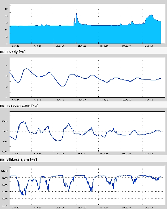
Teplota vzduchu a vody, vlhkost ,
 https://stanice.fiedler-magr.cz
Archiv
30_201329_2013
28_2013
27_2013
26_2013
25_2013
24_2013
23_2013
22_2013
21_2013
20_2013
19_2013
18_2013
17_2013
16_2013
15_2013
14_2013
13_2013
12_2013
11_2013
10_2013
09_2013
08_2013
07_2013
06_2013
05_2013
04_2013
03_2013
02_2013
01_2013

 | Zemědělská 1/1665 613 00 Brno Budova D | Tel.: +420 545 133 350 Fax.: +420 545 212 044 |  |
 |