

Není hanbou nic nevědět, ale je hanbou, nechtít se ničemu učit.
Konference
Konference v roce 2015
Konference v roce 2014
Konference v roce 2013
Konference v roce 2012
Konference v roce 2011


Polní laboratoř
NASA Sees Thirty-third Tropical Depression Form in Northwestern Pacific
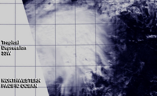 The Northwestern Pacific Ocean tropical cyclone season continues with the formation of the thirty-third tropical depression today, December 3, 2013.Two NASA satellites provided a look at the newly formed depression's cloud cover and rainfall rates.
At 0320 UTC today, NASA's Aqua satellite passed over the newborn depression. The Moderate Resolution Imaging Spectroradiometer or MODIS instrument captured a visible image of the storm, showing that the circulation had become more organized since the day before. The depression appeared as a rounded area of clouds on the MODIS image. NASA's Tropical Rainfall Measuring Mission or TRMM satellite also passed over the depression, but only over the northwestern edge. During the overpass, TRMM's Precipitation Radar instrument identified an area of moderate to heavy rainfall north of the center of circulation, where rain was falling at a rate of 1 inch/30 mm per hour.
On December 3 at 1500 UTC/10 a.m. EST, Tropical Depression 33W had maximum sustained winds near 30 knots/34.5 mph/55.5 kph. It was located approximately 369 nautical miles/424.6 miles/683.4 km west-northwest of Guam, near 16.0 north latitude and 138.9 east longitude. 33W was moving to the north at 6 knots/6.9 mph/11.1 kph but is expected to turn to the northeast.
The National Weather Service does not expect Guam to be adversely affected by the depression as forecasts for the next several days call for mostly sunny skies. Wednesday, December 4 is expected to bring the breeziest conditions from the depression. The National Weather Service expects winds on that day to be from the east-southeast at 10 to 15 mph, with gusts as high as 18 mph.
Forecasters at the Joint Typhoon Warning Center expect Tropical Depression 33W to become extra-tropical in the next day or two. The depression is expected to curve to the northeast and continue in that general direction for the next couple of days toward the Northern Mariana Islands.
The Northwestern Pacific Ocean tropical cyclone season continues with the formation of the thirty-third tropical depression today, December 3, 2013.Two NASA satellites provided a look at the newly formed depression's cloud cover and rainfall rates.
At 0320 UTC today, NASA's Aqua satellite passed over the newborn depression. The Moderate Resolution Imaging Spectroradiometer or MODIS instrument captured a visible image of the storm, showing that the circulation had become more organized since the day before. The depression appeared as a rounded area of clouds on the MODIS image. NASA's Tropical Rainfall Measuring Mission or TRMM satellite also passed over the depression, but only over the northwestern edge. During the overpass, TRMM's Precipitation Radar instrument identified an area of moderate to heavy rainfall north of the center of circulation, where rain was falling at a rate of 1 inch/30 mm per hour.
On December 3 at 1500 UTC/10 a.m. EST, Tropical Depression 33W had maximum sustained winds near 30 knots/34.5 mph/55.5 kph. It was located approximately 369 nautical miles/424.6 miles/683.4 km west-northwest of Guam, near 16.0 north latitude and 138.9 east longitude. 33W was moving to the north at 6 knots/6.9 mph/11.1 kph but is expected to turn to the northeast.
The National Weather Service does not expect Guam to be adversely affected by the depression as forecasts for the next several days call for mostly sunny skies. Wednesday, December 4 is expected to bring the breeziest conditions from the depression. The National Weather Service expects winds on that day to be from the east-southeast at 10 to 15 mph, with gusts as high as 18 mph.
Forecasters at the Joint Typhoon Warning Center expect Tropical Depression 33W to become extra-tropical in the next day or two. The depression is expected to curve to the northeast and continue in that general direction for the next couple of days toward the Northern Mariana Islands.
NASA Eyes Another Developing Depression in Northern Indian Ocean
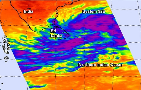 The Northern Indian Ocean typhoon season usually lasts until the end of December, but it's not going out without a fight this year. Infrared satellite data from NASA's Aqua satellite showed bands of thunderstorms wrapping around low pressure System 92B's center. If this system develops it would become Tropical Depression 06B.
NASA's Aqua satellite passed over the low pressure area designated as System 92B on Dec. 5 at 07:59 UTC/2:59 a.m. EST and the Atmospheric Infrared Sounder or AIRS instrument captured infrared data about the developing storm. AIRS data showed a large area of strong convection and high, cold thunderstorm cloud tops north and east of the center of circulation.
At the time of the AIRS image, the western-most edge of the low covered most of the island nation of Sri Lanka where it brought rain. AIRS data showed bands of thunderstorms also wrapping into the center from the west and south. The circulation appears to be consolidating today, December 5.
At 1500 UTC/10 a.m. EDT on December 5, System 92B as centered near 9.8 north and 84. 0 east, about 293 nautical miles southeast of Chennai, India. Winds in the area were estimated to be 25 to 30 knots/28.7 to 34.5 mph/46.3 to 55.5 kph. Satellite data indicated that the strongest winds were in the northern half of the low. The low pressure area is moving north-northeastward at 6 knots/6.9 mph/11.1 kph.
The low-level center of the system lies to the south of a subtropical ridge (elongated area) of high pressure, which is providing good outflow, but is also causing vertical wind shear, which is inhibiting the development.
The Joint Typhoon Warning Center expects this low pressure area to become a tropical depression and curve away from India. It is expected to move in a northeasterly direction toward the center of the Bay of Bengal.
The Northern Indian Ocean typhoon season usually lasts until the end of December, but it's not going out without a fight this year. Infrared satellite data from NASA's Aqua satellite showed bands of thunderstorms wrapping around low pressure System 92B's center. If this system develops it would become Tropical Depression 06B.
NASA's Aqua satellite passed over the low pressure area designated as System 92B on Dec. 5 at 07:59 UTC/2:59 a.m. EST and the Atmospheric Infrared Sounder or AIRS instrument captured infrared data about the developing storm. AIRS data showed a large area of strong convection and high, cold thunderstorm cloud tops north and east of the center of circulation.
At the time of the AIRS image, the western-most edge of the low covered most of the island nation of Sri Lanka where it brought rain. AIRS data showed bands of thunderstorms also wrapping into the center from the west and south. The circulation appears to be consolidating today, December 5.
At 1500 UTC/10 a.m. EDT on December 5, System 92B as centered near 9.8 north and 84. 0 east, about 293 nautical miles southeast of Chennai, India. Winds in the area were estimated to be 25 to 30 knots/28.7 to 34.5 mph/46.3 to 55.5 kph. Satellite data indicated that the strongest winds were in the northern half of the low. The low pressure area is moving north-northeastward at 6 knots/6.9 mph/11.1 kph.
The low-level center of the system lies to the south of a subtropical ridge (elongated area) of high pressure, which is providing good outflow, but is also causing vertical wind shear, which is inhibiting the development.
The Joint Typhoon Warning Center expects this low pressure area to become a tropical depression and curve away from India. It is expected to move in a northeasterly direction toward the center of the Bay of Bengal.
NASA Watching a Post-Atlantic Hurricane Season Low
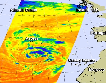 System 90L has developed in the eastern Atlantic Ocean today and NASA's Aqua satellite took an infrared look at the low pressure area to see if it had development potential. System 90L was located near 31.8 north and 28.1 west, about 450 miles
south of the Azores Islands.
NASA's Aqua satellite passed over the low pressure area on Dec. 5 and the Atmospheric Infrared Sounder or AIRS instrument captured infrared data on the clouds, revealing the strongest thunderstorms northeast of the center. The low is non-tropical and is generating tropical-storm-force winds near 60 mph.
The low is expected to be affected by strong upper-level winds shear and move over colder waters, both of which will inhibit and likely prevent organization. The National Hurricane Center gives it a low chance of becoming a subtropical or tropical cyclone in the next couple of days.
System 90L has developed in the eastern Atlantic Ocean today and NASA's Aqua satellite took an infrared look at the low pressure area to see if it had development potential. System 90L was located near 31.8 north and 28.1 west, about 450 miles
south of the Azores Islands.
NASA's Aqua satellite passed over the low pressure area on Dec. 5 and the Atmospheric Infrared Sounder or AIRS instrument captured infrared data on the clouds, revealing the strongest thunderstorms northeast of the center. The low is non-tropical and is generating tropical-storm-force winds near 60 mph.
The low is expected to be affected by strong upper-level winds shear and move over colder waters, both of which will inhibit and likely prevent organization. The National Hurricane Center gives it a low chance of becoming a subtropical or tropical cyclone in the next couple of days.
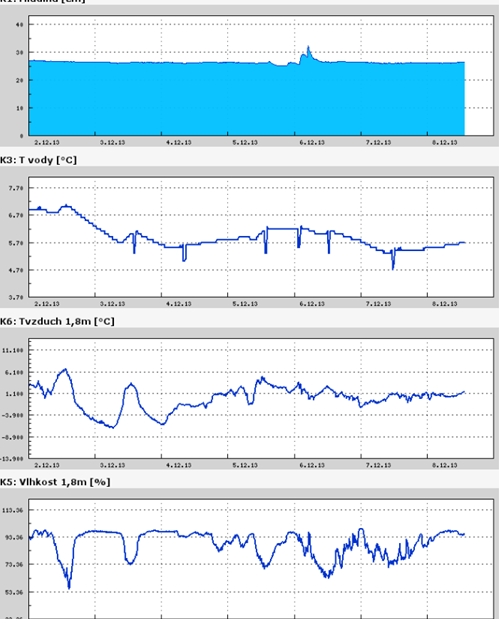
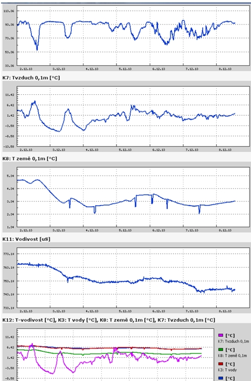
Teplota vzduchu a vody, vlhkost ,
 https://stanice.fiedler-magr.cz
Archiv
41_201340_2013
39_2013
38_2013
37_2013
36_2013
35_2013
34_2013
33_2013
32_2013
31_2013
30_2013
29_2013
28_2013
27_2013
26_2013
25_2013
24_2013
23_2013
22_2013
21_2013
20_2013
19_2013
18_2013
17_2013
16_2013
15_2013
14_2013
13_2013
12_2013
11_2013
10_2013
09_2013
08_2013
07_2013
06_2013
05_2013
04_2013
03_2013
02_2013
01_2013

 | Zemědělská 1/1665 613 00 Brno Budova D | Tel.: +420 545 133 350 Fax.: +420 545 212 044 |  |
 |