

Průměrný učitel vypráví. Dobrý učitel vysvětluje. Výborný učitel ukazuje. Nejlepší učitel inspiruje.
Charles Farrar Browne
Konference
Konference v roce 2015
Konference v roce 2014
Konference v roce 2013
Konference v roce 2012
Konference v roce 2011


Polní laboratoř
NASA Sees Late Season Subtropical Storm Melissa Form in Atlantic
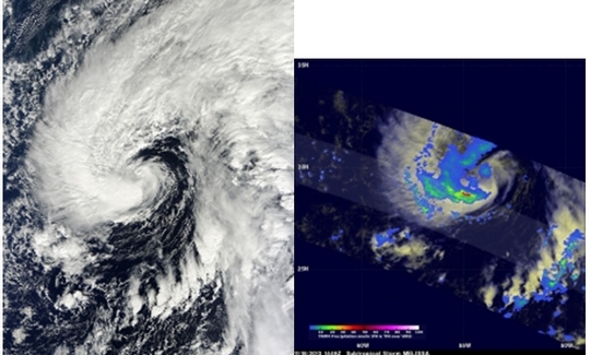 Hurricane Season ends on November 30, and subtropical storm Melissa formed with less than two weeks to go. Melissa formed on Monday, November 18 about 695 miles/1,120 km east-southeast of Bermuda, near 29.3 north and 53.6 west. It had maximum sustained winds near 50 mph/85 kph and was moving to the northwest at 9 mph/15 kph.
NASA's TRMM satellite flew above subtropical storm Melissa as it formed in the central Atlantic Ocean on November 18, 2013 at 1449 UTC (9:49 a.m. EST). TRMM captured rainfall data on Melissa using TRMM's Microwave Imager (TMI) and Precipitation Radar (PR). Both data were overlaid on an enhanced visible/infrared image from TRMM's Visible and InfraRed Scanner (VIRS). The TRMM pass found that the heaviest rainfall within Melissa was falling at a rate of over 74mm~2.9 inches per hour in an area of strong convective rainfall that was wrapping around the southern side of the storm. On Nov. 19 at 10 a.m. EST, Melissa was moving north over the central Atlantic Ocean and the National Hurricane Center expects it to transition into a tropical storm later in the day. At 1500 UTC/10 a.m. EST, Melissa's maximum sustained winds were near 65 mph/100 kph. It was moving to the north at 10 mph/17 kph. Melissa's center was located about 595 miles/960 km east of Bermuda, near 31.9 north and 54.6 west.
The National Hurricane Center reported that various satellite data indicate that Melissa appears to be separating from the elongated parent cloud band east of the circulation center suggesting that the storm may be transitioning into a tropical cyclone. Although Melissa is not a threat to land, the subtropical storm is causing rough surf and large swells to affect Bermuda, parts of the northern Leeward Islands, Puerto Rico, Hispaniola and southeastern Bahamas. Those conditions are expected to continue over the next couple of days and include life-threatening surf and rip currents.
Melissa is expected to the move to the north-northeast over the open waters of the North Atlantic Ocean and become a tropical storm later on Nov. 19
Hurricane Season ends on November 30, and subtropical storm Melissa formed with less than two weeks to go. Melissa formed on Monday, November 18 about 695 miles/1,120 km east-southeast of Bermuda, near 29.3 north and 53.6 west. It had maximum sustained winds near 50 mph/85 kph and was moving to the northwest at 9 mph/15 kph.
NASA's TRMM satellite flew above subtropical storm Melissa as it formed in the central Atlantic Ocean on November 18, 2013 at 1449 UTC (9:49 a.m. EST). TRMM captured rainfall data on Melissa using TRMM's Microwave Imager (TMI) and Precipitation Radar (PR). Both data were overlaid on an enhanced visible/infrared image from TRMM's Visible and InfraRed Scanner (VIRS). The TRMM pass found that the heaviest rainfall within Melissa was falling at a rate of over 74mm~2.9 inches per hour in an area of strong convective rainfall that was wrapping around the southern side of the storm. On Nov. 19 at 10 a.m. EST, Melissa was moving north over the central Atlantic Ocean and the National Hurricane Center expects it to transition into a tropical storm later in the day. At 1500 UTC/10 a.m. EST, Melissa's maximum sustained winds were near 65 mph/100 kph. It was moving to the north at 10 mph/17 kph. Melissa's center was located about 595 miles/960 km east of Bermuda, near 31.9 north and 54.6 west.
The National Hurricane Center reported that various satellite data indicate that Melissa appears to be separating from the elongated parent cloud band east of the circulation center suggesting that the storm may be transitioning into a tropical cyclone. Although Melissa is not a threat to land, the subtropical storm is causing rough surf and large swells to affect Bermuda, parts of the northern Leeward Islands, Puerto Rico, Hispaniola and southeastern Bahamas. Those conditions are expected to continue over the next couple of days and include life-threatening surf and rip currents.
Melissa is expected to the move to the north-northeast over the open waters of the North Atlantic Ocean and become a tropical storm later on Nov. 19
Tropical Cyclone 04B Forms in Northern Indian Ocean
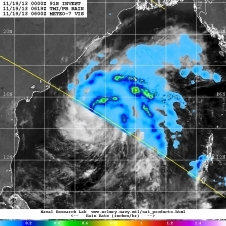 The fourth tropical cyclone of the Northern Indian Ocean season formed and is headed for landfall in a couple of days in southeastern India. NASA's TRMM satellite saw broken bands of thunderstorms with moderate rainfall in the northern and eastern quadrants of Tropical Cyclone 04B on Nov. 19.
Tropical Cyclone 04B was located just 180 nautical miles south-southeast of Visakhapatnam, India near 15.0 north and 84.5 east at 1500 UTC/10 a.m. EST on Nov. 19. 04B had maximum sustained winds near 35 knots/40 mph/64 kph and is moving to the west at 8 knots/9.2 mph/14.8 kph.
Satellite imagery showed that the low-level center is organized and there is convection (building thunderstorms) flaring around the storm's center and there is broken bands of thunderstorms around the northern quadrant of the storm. TRMM satellite data showed rainfall rates were as high as 1.2 inches/30.4 mm per hour.
A microwave image from Nov. 19 at 1058 UTC/5:58 a.m. EST showed that the cyclone is well-defined and has curved bands of thunderstorms along the western quadrant.
The Joint Typhoon Warning Center or JTWC expects 04B to track slowly west slowly intensify before making landfall in India as a tropical storm. The JTWC expects landfall between Ongole south to Nellore, both cities in the southern India state of Andhra Pradesh late on Nov. 21.
The fourth tropical cyclone of the Northern Indian Ocean season formed and is headed for landfall in a couple of days in southeastern India. NASA's TRMM satellite saw broken bands of thunderstorms with moderate rainfall in the northern and eastern quadrants of Tropical Cyclone 04B on Nov. 19.
Tropical Cyclone 04B was located just 180 nautical miles south-southeast of Visakhapatnam, India near 15.0 north and 84.5 east at 1500 UTC/10 a.m. EST on Nov. 19. 04B had maximum sustained winds near 35 knots/40 mph/64 kph and is moving to the west at 8 knots/9.2 mph/14.8 kph.
Satellite imagery showed that the low-level center is organized and there is convection (building thunderstorms) flaring around the storm's center and there is broken bands of thunderstorms around the northern quadrant of the storm. TRMM satellite data showed rainfall rates were as high as 1.2 inches/30.4 mm per hour.
A microwave image from Nov. 19 at 1058 UTC/5:58 a.m. EST showed that the cyclone is well-defined and has curved bands of thunderstorms along the western quadrant.
The Joint Typhoon Warning Center or JTWC expects 04B to track slowly west slowly intensify before making landfall in India as a tropical storm. The JTWC expects landfall between Ongole south to Nellore, both cities in the southern India state of Andhra Pradesh late on Nov. 21.
A Portrait of Global Winds
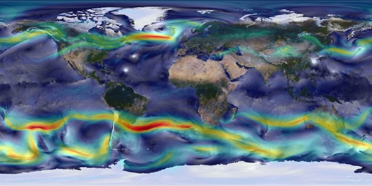 High-resolution global atmospheric modeling provides a unique tool to study the role of weather within Earth’s climate system. NASA’s Goddard Earth Observing System Model (GEOS-5) is capable of simulating worldwide weather at resolutions as fine as 3.5 kilometers. This visualization shows global winds from a GEOS-5 simulation using 10-kilometer resolution. Surface winds (0 to 40 meters/second) are shown in white and trace features including Atlantic and Pacific cyclones. Upper-level winds (250 hectopascals) are colored by speed (0 to 175 meters/second), with red indicating faster.
This simulation ran on the Discover supercomputer at the NASA Center for Climate Simulation. The complete 2-year “Nature Run” simulation—a computer model representation of Earth's atmosphere from basic inputs including observed sea-surface temperatures and surface emissions from biomass burning, volcanoes and anthropogenic sources—produces its own unique weather patterns including precipitation, aerosols and hurricanes. A follow-on Nature Run is simulating Earth’s atmosphere at 7 kilometers for 2 years and 3.5 kilometers for 3 months.
Image Credit: William Putman/NASA Goddard Space Flight Center
Related: NASA will showcase more than 30 of the agency's exciting computational achievements at SC13, the international supercomputing conference, Nov. 17-22, 2013 in Denver.
High-resolution global atmospheric modeling provides a unique tool to study the role of weather within Earth’s climate system. NASA’s Goddard Earth Observing System Model (GEOS-5) is capable of simulating worldwide weather at resolutions as fine as 3.5 kilometers. This visualization shows global winds from a GEOS-5 simulation using 10-kilometer resolution. Surface winds (0 to 40 meters/second) are shown in white and trace features including Atlantic and Pacific cyclones. Upper-level winds (250 hectopascals) are colored by speed (0 to 175 meters/second), with red indicating faster.
This simulation ran on the Discover supercomputer at the NASA Center for Climate Simulation. The complete 2-year “Nature Run” simulation—a computer model representation of Earth's atmosphere from basic inputs including observed sea-surface temperatures and surface emissions from biomass burning, volcanoes and anthropogenic sources—produces its own unique weather patterns including precipitation, aerosols and hurricanes. A follow-on Nature Run is simulating Earth’s atmosphere at 7 kilometers for 2 years and 3.5 kilometers for 3 months.
Image Credit: William Putman/NASA Goddard Space Flight Center
Related: NASA will showcase more than 30 of the agency's exciting computational achievements at SC13, the international supercomputing conference, Nov. 17-22, 2013 in Denver.
NASA Sees Tropical Cyclone Alessia Form, Threaten Western Australia
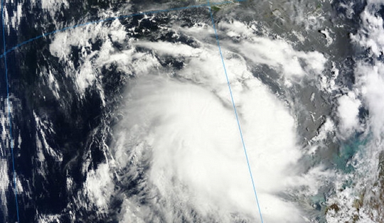 The low pressure area previously known as System 90S has continued organizing and consolidating and infrared data from NASA's Aqua satellite helped confirm its strengthening into Cyclone Alessia in the Southern Indian Ocean. Alessia formed off of Western Australia's Kimberley coast and the first Cyclone Warnings and Watches of the season are now in effect. The Moderate Resolution Imaging Spectroradiometer instrument called MODIS that flies aboard NASA's Terra satellite captured a visible image of newly-developed Tropical Cyclone Alessia on Nov. 22 at 02:20 UTC/Nov. 21 at 9:20 p.m. EST. The image showed good circulation and bands of thunderstorms wrapping around the center of circulation from the east and west. Even multispectral satellite imagery showed that the bands of thunderstorms had become more tightly wrapped around the storm's center.
On November 22 at 0900 UTC/4 a.m. EST, Tropical Cyclone Alessia was located about 237 nautical miles/ 272.7 miles/438.9 km northwest of Broome, Australia, near 14.5 south latitude and 120.1 east longitude. Cyclone Alessia had maximum sustained winds near 35 knots/40 mph/62 kph. Alessia was moving to the east-southeast at 14 knots/16.1 mph/25.9 kph toward Western Australia. Forecasters are expecting Alessia to move in a more easterly direction toward Darwin.
Warnings and watches are already in effect for Western Australia. A Cyclone Warning is in effect from Cockatoo Island to Wyndham, and a Cyclone Watch is in effect from coastal areas from Wyndham to Cape Hotham.
According to the bulletin from the Australian Bureau of Meteorology or ABM, gales may develop along the northern Kimberley coast on November 23 as Alessia approaches the coast. The tropical cyclone is expected to brush the northern Kimberley coast and weaken as it approaches the west coast of the Top End on Sunday, November 24. Forecasters at the ABM expect rainfall to be limited to coastal areas. For updated warnings and watches, visit ABM's website at: http://www.bom.gov.au/wa/warnings/.
The Joint Typhoon Warning Center or JTWC forecasters expect Alessia to strengthen before making landfall near Darwin in the next couple of days. The JWTC noted that after Alessia makes landfall it will move across the swampy terrain of northern Australia just south of Darwin and should dissipate in five days (by November 27).
The low pressure area previously known as System 90S has continued organizing and consolidating and infrared data from NASA's Aqua satellite helped confirm its strengthening into Cyclone Alessia in the Southern Indian Ocean. Alessia formed off of Western Australia's Kimberley coast and the first Cyclone Warnings and Watches of the season are now in effect. The Moderate Resolution Imaging Spectroradiometer instrument called MODIS that flies aboard NASA's Terra satellite captured a visible image of newly-developed Tropical Cyclone Alessia on Nov. 22 at 02:20 UTC/Nov. 21 at 9:20 p.m. EST. The image showed good circulation and bands of thunderstorms wrapping around the center of circulation from the east and west. Even multispectral satellite imagery showed that the bands of thunderstorms had become more tightly wrapped around the storm's center.
On November 22 at 0900 UTC/4 a.m. EST, Tropical Cyclone Alessia was located about 237 nautical miles/ 272.7 miles/438.9 km northwest of Broome, Australia, near 14.5 south latitude and 120.1 east longitude. Cyclone Alessia had maximum sustained winds near 35 knots/40 mph/62 kph. Alessia was moving to the east-southeast at 14 knots/16.1 mph/25.9 kph toward Western Australia. Forecasters are expecting Alessia to move in a more easterly direction toward Darwin.
Warnings and watches are already in effect for Western Australia. A Cyclone Warning is in effect from Cockatoo Island to Wyndham, and a Cyclone Watch is in effect from coastal areas from Wyndham to Cape Hotham.
According to the bulletin from the Australian Bureau of Meteorology or ABM, gales may develop along the northern Kimberley coast on November 23 as Alessia approaches the coast. The tropical cyclone is expected to brush the northern Kimberley coast and weaken as it approaches the west coast of the Top End on Sunday, November 24. Forecasters at the ABM expect rainfall to be limited to coastal areas. For updated warnings and watches, visit ABM's website at: http://www.bom.gov.au/wa/warnings/.
The Joint Typhoon Warning Center or JTWC forecasters expect Alessia to strengthen before making landfall near Darwin in the next couple of days. The JWTC noted that after Alessia makes landfall it will move across the swampy terrain of northern Australia just south of Darwin and should dissipate in five days (by November 27).
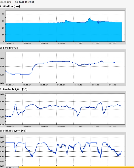
Teplota vzduchu a vody, vlhkost ,
 https://stanice.fiedler-magr.cz
Archiv
39_201338_2013
37_2013
36_2013
35_2013
34_2013
33_2013
32_2013
31_2013
30_2013
29_2013
28_2013
27_2013
26_2013
25_2013
24_2013
23_2013
22_2013
21_2013
20_2013
19_2013
18_2013
17_2013
16_2013
15_2013
14_2013
13_2013
12_2013
11_2013
10_2013
09_2013
08_2013
07_2013
06_2013
05_2013
04_2013
03_2013
02_2013
01_2013

 | Zemědělská 1/1665 613 00 Brno Budova D | Tel.: +420 545 133 350 Fax.: +420 545 212 044 |  |
 |