

Účelem vzdělání není zaplnit mysl, ale otevřít ji. Čím více poznatků si osvojíme, tím víc si uvědomíme, co ještě neznáme.
Konference
Konference v roce 2015
Konference v roce 2014
Konference v roce 2013
Konference v roce 2012
Konference v roce 2011


Polní laboratoř
NASA Sees Strengthening Tropical Storm Haiyan Lashing Micronesia
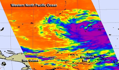 NASA's Aqua satellite passed over Tropical Storm Haiyan on Nov. 4 and infrared data showed a large area of powerful thunderstorms affecting Micronesia. The Joint Typhoon Warning Center has forecast newborn Tropical Storm Haiyan to strengthen to a powerful typhoon before making landfall in the Philippines on Nov 8.
In its orbit around the Earth, NASA's Aqua satellite passed over Tropical Storm Haiyan on Nov. 4 at 0347 UTC/10:47 p.m. EDT on Nov. 3. The Atmospheric Infrared Sounder or AIRS instrument captured infrared data that measured cloud top temperatures in the strengthening tropical storm. AIRS data showed a large area of strong convection with high, cold cloud tops. Temperatures exceeded -63F/-52C over a large area. Satellite data shows that the convection, the rising air that forms the thunderstorms that make up the tropical cyclone, have deepened, or strengthened over the previous 24 hours.
Microwave imagery from NASA's Tropical Rainfall Measuring Mission or TRMM satellite shows improved banding of thunderstorms wrapping around the tropical storm today, Nov. 5.
Haiyan is lashing the islands of Micronesia and warnings and watches are in effect today, Nov. 5.
Micronesia consists of a group of islands in the western Pacific Ocean that include the Marshall Islands, the Gilbert Islands including Kiribati, the Caroline Islands, Nauru, Wake Island and the Mariana Islands. The area contains thousands of small islands and is part of the larger Oceana.
A Typhoon Warning is in effect for Woleai in Yap State. A Typhoon Watch is in effect for Koror and Kayangel, Republic of Palau; for Satawal in Yap State; and for Faraulep, Fais, Ulithi, Yap Island and Ngulu in Yap State. A Tropical Storm Warning has been posted for Puluwat in Chuuk State as well as for Satawal in Yap State, and a tropical storm Watch is up for Ulul and Fananu in Chuuk State.
On Nov. 5 at 1500 UTC/10 a.m. EDT Haiyan's maximum sustained winds were near 45 knots/51.7 mph/83.3 kph and it is moving through an area of warm waters and low wind shear which is expected to help the storm strengthen. Haiyan was centered near 6.2 north and 147.6 east about 640 nautical miles east-southeast of Yap. Haiyan is moving to the west at 19 knots/21.8 mph/35.9 kph.
Haiyan is moving west-northwest through Micronesia. It is expected to pass between Yap and Palau on Nov. 6 before making landfall in the central Philippines. The Joint Typhoon Warning Center expects Haiyan to intensify to 120 knots/138.1 mph/222.2 kph as it approaches the central Philippines on Nov. 8. That strength is equal to a Category 4 hurricane on the Saffir-Simpson Scale.
NASA's Aqua satellite passed over Tropical Storm Haiyan on Nov. 4 and infrared data showed a large area of powerful thunderstorms affecting Micronesia. The Joint Typhoon Warning Center has forecast newborn Tropical Storm Haiyan to strengthen to a powerful typhoon before making landfall in the Philippines on Nov 8.
In its orbit around the Earth, NASA's Aqua satellite passed over Tropical Storm Haiyan on Nov. 4 at 0347 UTC/10:47 p.m. EDT on Nov. 3. The Atmospheric Infrared Sounder or AIRS instrument captured infrared data that measured cloud top temperatures in the strengthening tropical storm. AIRS data showed a large area of strong convection with high, cold cloud tops. Temperatures exceeded -63F/-52C over a large area. Satellite data shows that the convection, the rising air that forms the thunderstorms that make up the tropical cyclone, have deepened, or strengthened over the previous 24 hours.
Microwave imagery from NASA's Tropical Rainfall Measuring Mission or TRMM satellite shows improved banding of thunderstorms wrapping around the tropical storm today, Nov. 5.
Haiyan is lashing the islands of Micronesia and warnings and watches are in effect today, Nov. 5.
Micronesia consists of a group of islands in the western Pacific Ocean that include the Marshall Islands, the Gilbert Islands including Kiribati, the Caroline Islands, Nauru, Wake Island and the Mariana Islands. The area contains thousands of small islands and is part of the larger Oceana.
A Typhoon Warning is in effect for Woleai in Yap State. A Typhoon Watch is in effect for Koror and Kayangel, Republic of Palau; for Satawal in Yap State; and for Faraulep, Fais, Ulithi, Yap Island and Ngulu in Yap State. A Tropical Storm Warning has been posted for Puluwat in Chuuk State as well as for Satawal in Yap State, and a tropical storm Watch is up for Ulul and Fananu in Chuuk State.
On Nov. 5 at 1500 UTC/10 a.m. EDT Haiyan's maximum sustained winds were near 45 knots/51.7 mph/83.3 kph and it is moving through an area of warm waters and low wind shear which is expected to help the storm strengthen. Haiyan was centered near 6.2 north and 147.6 east about 640 nautical miles east-southeast of Yap. Haiyan is moving to the west at 19 knots/21.8 mph/35.9 kph.
Haiyan is moving west-northwest through Micronesia. It is expected to pass between Yap and Palau on Nov. 6 before making landfall in the central Philippines. The Joint Typhoon Warning Center expects Haiyan to intensify to 120 knots/138.1 mph/222.2 kph as it approaches the central Philippines on Nov. 8. That strength is equal to a Category 4 hurricane on the Saffir-Simpson Scale.
Upsala Glacier Retreat
 This photograph by an astronaut on the International Space Station highlights the snout of the Upsala Glacier (49.88°S, 73.3°W) on the Argentine side of the North Patagonian Icefield. Ice flow in this glacier comes from the north (right in this rotated image). Dark lines of rocky debris (moraine) within the ice give a sense of the slow ice flow from right to left. A smaller, side glacier joins Upsala at the present-day ice front -- the wall from which masses of ice periodically collapse into Lago (Lake) Argentino. In this image, the 2.7 kilometer-wide ice front casts a thin, dark shadow.
The surface of Lago Argentino is whitened by a mass of debris from a recent collapse of the ice wall. Larger icebergs appear as white dots on the lake surface at image left. Remotely sensed data, including astronaut images, have recorded the position of the ice front over the years. A comparison of this October 2013 image with older data (January 2004 and January 2001, as well as October 2009) indicates that the ice front has moved backwards -- upstream -- about 3 kilometers (2 miles). This retreat is believed by scientists to indicate climate warming in this part of South America. The warming not only causes the ice mass to retreat, but also to thin. A study of 63 glaciers by Rignot et al has shown that this is a general trend in Patagonia. The water color in Lago Argentino is related to the glacier flow. The lake receives most of the ice from the glacier and thus receives most of the “rock flour” -- rocks ground to white powder by the ice scraping against the rock floor of the valley. Glacial flour turns the lake a gray-green hue in this image. The darker blue of the smaller lakes (image bottom) indicates that they are receiving much less rock flour. This image was taken on Oct. 2, 2013, with a Nikon D3 digital camera using a 300 millimeter lens, and is provided by the ISS Crew Earth Observations experiment and Image Science & Analysis Laboratory, Johnson Space Center. It has been cropped and enhanced to improve contrast, and lens artifacts have been removed. > View the annotated version of this image at NASA's Earth Observatory website Image Credit: NASA Caption: M. Justin Wilkinson, Jacobs at NASA-Johnson Space Center
This photograph by an astronaut on the International Space Station highlights the snout of the Upsala Glacier (49.88°S, 73.3°W) on the Argentine side of the North Patagonian Icefield. Ice flow in this glacier comes from the north (right in this rotated image). Dark lines of rocky debris (moraine) within the ice give a sense of the slow ice flow from right to left. A smaller, side glacier joins Upsala at the present-day ice front -- the wall from which masses of ice periodically collapse into Lago (Lake) Argentino. In this image, the 2.7 kilometer-wide ice front casts a thin, dark shadow.
The surface of Lago Argentino is whitened by a mass of debris from a recent collapse of the ice wall. Larger icebergs appear as white dots on the lake surface at image left. Remotely sensed data, including astronaut images, have recorded the position of the ice front over the years. A comparison of this October 2013 image with older data (January 2004 and January 2001, as well as October 2009) indicates that the ice front has moved backwards -- upstream -- about 3 kilometers (2 miles). This retreat is believed by scientists to indicate climate warming in this part of South America. The warming not only causes the ice mass to retreat, but also to thin. A study of 63 glaciers by Rignot et al has shown that this is a general trend in Patagonia. The water color in Lago Argentino is related to the glacier flow. The lake receives most of the ice from the glacier and thus receives most of the “rock flour” -- rocks ground to white powder by the ice scraping against the rock floor of the valley. Glacial flour turns the lake a gray-green hue in this image. The darker blue of the smaller lakes (image bottom) indicates that they are receiving much less rock flour. This image was taken on Oct. 2, 2013, with a Nikon D3 digital camera using a 300 millimeter lens, and is provided by the ISS Crew Earth Observations experiment and Image Science & Analysis Laboratory, Johnson Space Center. It has been cropped and enhanced to improve contrast, and lens artifacts have been removed. > View the annotated version of this image at NASA's Earth Observatory website Image Credit: NASA Caption: M. Justin Wilkinson, Jacobs at NASA-Johnson Space Center
NASA Sees Tropical Depression 30W Affecting Central Philippines
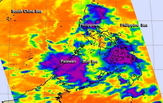 Tropical Depression 30W formed and moved through Visayas, Philippines. NASA's Aqua satellite captured an infrared image of the depression that showed it had some potential for heavy rain while moving through the central Philippines.
NASA's Aqua satellite passed over Tropical Depression 30W, known locally as "Wilma," on Nov. 4 at 0529 UTC/12:29 a.m. EDT/1:29 p.m. Philippines local time as it was moving through Visayas, central Philippines. The coldest cloud tops with potential for heavy rainfall were as cold as -63F/-52C and covered Visayas and extended west to Palawan. Palawan is an island province of the Philippines, west of Visayas. The Philippine Atmospheric, Geophysical and Astronomical Services Administration (PAGASA) noted on Nov. 4 that the depression weakened to a low pressure area by 5 p.m. local time. At that time the center of the low was about 9.3 miles/15 km southwest of Tagbilaran City and was bringing rains and gusty winds to Visayas and Mindanao. Local radar at 1:30 p.m. EST/18:30 UTC on Nov. 4/2:30 a.m. local time, Nov. 5, showed the heaviest precipitation had moved west of Visayas and was in part over northern Palawan as it headed further west into the South China Sea.
At 2 p.m. local time/1 a.m. EST, PAGASA issued the final bulletin on former Tropical Depression 30W. At that time, the center of the low pressure area was about 19.8 miles/32 km southeast of Tagbilaran City. Now that former Tropical Depression 30W was wrapping up for the Philippines, residents of Visayas are keeping a close eye on Tropical Storm Haiyan moving their way from the east.
This isn't the end of Tropical Depression 30W, however. Now that it is in the warm waters of the South China Sea, the Joint Typhoon Warning Center expects it to re-strengthen. On Nov. 4 at 1500 UTC/10 a.m. EST, maximum sustained winds were near 30 knots/34.5 mph/55.5 kph and it had regained its status as a depression. It was located near 13.4 north and 93.4 east, about 267 nautical miles east of Puerto Princesa, Philippines. It was moving quickly to the west at 21 knots/24.1 mph/38.8 kph and is expected to reach tropical storm strength in the next day or two.
The Joint Typhoon Warning Center forecast brings the depression to southern Vietnam for a landfall sometime on Nov. 6.
Tropical Depression 30W formed and moved through Visayas, Philippines. NASA's Aqua satellite captured an infrared image of the depression that showed it had some potential for heavy rain while moving through the central Philippines.
NASA's Aqua satellite passed over Tropical Depression 30W, known locally as "Wilma," on Nov. 4 at 0529 UTC/12:29 a.m. EDT/1:29 p.m. Philippines local time as it was moving through Visayas, central Philippines. The coldest cloud tops with potential for heavy rainfall were as cold as -63F/-52C and covered Visayas and extended west to Palawan. Palawan is an island province of the Philippines, west of Visayas. The Philippine Atmospheric, Geophysical and Astronomical Services Administration (PAGASA) noted on Nov. 4 that the depression weakened to a low pressure area by 5 p.m. local time. At that time the center of the low was about 9.3 miles/15 km southwest of Tagbilaran City and was bringing rains and gusty winds to Visayas and Mindanao. Local radar at 1:30 p.m. EST/18:30 UTC on Nov. 4/2:30 a.m. local time, Nov. 5, showed the heaviest precipitation had moved west of Visayas and was in part over northern Palawan as it headed further west into the South China Sea.
At 2 p.m. local time/1 a.m. EST, PAGASA issued the final bulletin on former Tropical Depression 30W. At that time, the center of the low pressure area was about 19.8 miles/32 km southeast of Tagbilaran City. Now that former Tropical Depression 30W was wrapping up for the Philippines, residents of Visayas are keeping a close eye on Tropical Storm Haiyan moving their way from the east.
This isn't the end of Tropical Depression 30W, however. Now that it is in the warm waters of the South China Sea, the Joint Typhoon Warning Center expects it to re-strengthen. On Nov. 4 at 1500 UTC/10 a.m. EST, maximum sustained winds were near 30 knots/34.5 mph/55.5 kph and it had regained its status as a depression. It was located near 13.4 north and 93.4 east, about 267 nautical miles east of Puerto Princesa, Philippines. It was moving quickly to the west at 21 knots/24.1 mph/38.8 kph and is expected to reach tropical storm strength in the next day or two.
The Joint Typhoon Warning Center forecast brings the depression to southern Vietnam for a landfall sometime on Nov. 6.
Teplota vzduchu a vody, vlhkost ,
 https://stanice.fiedler-magr.cz
Archiv
38_201337_2013
36_2013
35_2013
34_2013
33_2013
32_2013
31_2013
30_2013
29_2013
28_2013
27_2013
26_2013
25_2013
24_2013
23_2013
22_2013
21_2013
20_2013
19_2013
18_2013
17_2013
16_2013
15_2013
14_2013
13_2013
12_2013
11_2013
10_2013
09_2013
08_2013
07_2013
06_2013
05_2013
04_2013
03_2013
02_2013
01_2013

 | Zemědělská 1/1665 613 00 Brno Budova D | Tel.: +420 545 133 350 Fax.: +420 545 212 044 |  |
 |