

Učit se znamená objevovat to, co už víš.
Konat znamená demonstrovat, že to to víš.
Učit druhé znamená připomínat jim, že to vědí stejně dobře jako ty.
Všichni jste zároveň žáci, praktikanti a učitelé.
Richard Bach
Konference
Konference v roce 2015
Konference v roce 2014
Konference v roce 2013
Konference v roce 2012
Konference v roce 2011


Polní laboratoř
NASA Catches Glimpse of the Brief Life of Southern Indian Ocean's First Tropical Cyclone
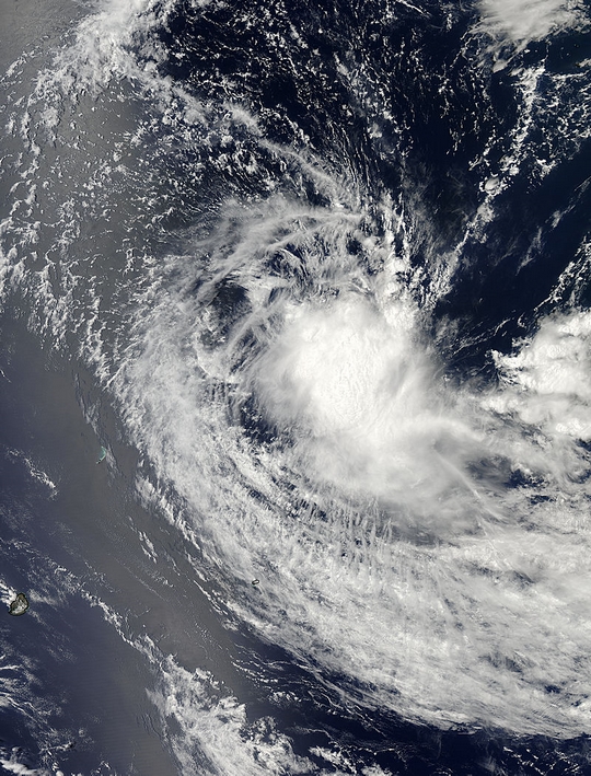 The first tropical cyclone of the Southern Indian Ocean season lasted about one day. Tropical Cyclone 01S was born on Oct. 27 and by Oct. 28 had become a remnant low.
The first tropical cyclone of the Southern Indian Ocean cyclone season formed on Oct. 27 near 13.1 south and 63.4 east, about 570 nautical miles northeast of Port Louis, Mauritus. It was moving to the west-southwest at 7 knots. Maximum sustained winds were near 35 knots.
On Oct. 27, satellite imagery showed that the low-level circulation center is elongated indicating the system was battling wind shear. Satellite imagery revealed that the strongest convection was around the southern edge of the center. Maximum sustained winds were near 35 knots/40 mph/64.8 kph and the storm was moving west.
The Moderate Resolution Imaging Spectroradiometer or MODIS instrument aboard NASA's Aqua satellite captured a visible image of Tropical Cyclone 01S in the South Indian Ocean. The image was taken on Oct. 27 at 09:30 UTC/4:30 a.m. EDT and showed an elongated storm.
On Oct. 28 at 0000 UTC/Oct. 27 at 8 p.m. EDT, Tropical Cyclone 01S was located near 13.1 south latitude and
62.5 east longitude, approximately 550 nautical miles north-northeast of La Reunion Island. Despite the maximum sustained winds near 35 knots/40 mph/64.8 kph, the storm was weakening and was expected to weaken because of wind shear
The first tropical cyclone of the Southern Indian Ocean season lasted about one day. Tropical Cyclone 01S was born on Oct. 27 and by Oct. 28 had become a remnant low.
The first tropical cyclone of the Southern Indian Ocean cyclone season formed on Oct. 27 near 13.1 south and 63.4 east, about 570 nautical miles northeast of Port Louis, Mauritus. It was moving to the west-southwest at 7 knots. Maximum sustained winds were near 35 knots.
On Oct. 27, satellite imagery showed that the low-level circulation center is elongated indicating the system was battling wind shear. Satellite imagery revealed that the strongest convection was around the southern edge of the center. Maximum sustained winds were near 35 knots/40 mph/64.8 kph and the storm was moving west.
The Moderate Resolution Imaging Spectroradiometer or MODIS instrument aboard NASA's Aqua satellite captured a visible image of Tropical Cyclone 01S in the South Indian Ocean. The image was taken on Oct. 27 at 09:30 UTC/4:30 a.m. EDT and showed an elongated storm.
On Oct. 28 at 0000 UTC/Oct. 27 at 8 p.m. EDT, Tropical Cyclone 01S was located near 13.1 south latitude and
62.5 east longitude, approximately 550 nautical miles north-northeast of La Reunion Island. Despite the maximum sustained winds near 35 knots/40 mph/64.8 kph, the storm was weakening and was expected to weaken because of wind shear
NASA Sees Newborn Twenty-ninth Depression in the Philippine Sea
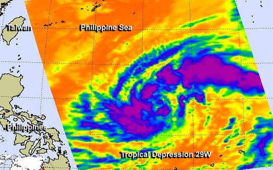 NASA infrared imagery revealed that bands of thunderstorms have been wrapping into the center of newborn Tropical Depression 29W, indicating it's organizing and strengthening in the Philippine Sea. The Philippine Sea is located within the northwestern Pacific Ocean. It's located east and north of the Philippines and covers about 2 million square miles (5 million square kilometers).
The Atmospheric Infrared Sounder or AIRS instrument aboard NASA's Aqua satellite captured infrared data on Tropical Depression 29W on Oct. 29 at 04:23 UTC/12:23 a.m. EDT. AIRS data revealed strong thunderstorms with cloud top temperatures exceeding -63F/-52C that indicated they were high in the troposphere. They thunderstorms appeared in bands west and east of the center. Those thunderstorms were part of bands that formed around the circulation center.
On Oct. 29 at 11 a.m. EDT/1500 UTC, Tropical Depression 29W had maximum sustained winds near 30 knots/34.5 mph/55.5 kph. It was located near 15.7 north and 131.3 east, about 634 nautical miles/729.6 miles/1,174 km east of Manila, Philippines. 29W is moving to the west at 14 knots/16.1 mph/21.3 kph and is expected to continue moving in that general direction over the next couple of days.
Forecasters at the Joint Typhoon Warning Center noted that warm sea surface temperatures in the Philippine Sea (where it is currently moving through) will enable 29W to strengthen into a typhoon in the next one or two days.
29W is expected to move west crossing over Luzon (the northern Philippines) as a tropical storm sometime on Oct. 31 then move into the South China Sea.
NASA infrared imagery revealed that bands of thunderstorms have been wrapping into the center of newborn Tropical Depression 29W, indicating it's organizing and strengthening in the Philippine Sea. The Philippine Sea is located within the northwestern Pacific Ocean. It's located east and north of the Philippines and covers about 2 million square miles (5 million square kilometers).
The Atmospheric Infrared Sounder or AIRS instrument aboard NASA's Aqua satellite captured infrared data on Tropical Depression 29W on Oct. 29 at 04:23 UTC/12:23 a.m. EDT. AIRS data revealed strong thunderstorms with cloud top temperatures exceeding -63F/-52C that indicated they were high in the troposphere. They thunderstorms appeared in bands west and east of the center. Those thunderstorms were part of bands that formed around the circulation center.
On Oct. 29 at 11 a.m. EDT/1500 UTC, Tropical Depression 29W had maximum sustained winds near 30 knots/34.5 mph/55.5 kph. It was located near 15.7 north and 131.3 east, about 634 nautical miles/729.6 miles/1,174 km east of Manila, Philippines. 29W is moving to the west at 14 knots/16.1 mph/21.3 kph and is expected to continue moving in that general direction over the next couple of days.
Forecasters at the Joint Typhoon Warning Center noted that warm sea surface temperatures in the Philippine Sea (where it is currently moving through) will enable 29W to strengthen into a typhoon in the next one or two days.
29W is expected to move west crossing over Luzon (the northern Philippines) as a tropical storm sometime on Oct. 31 then move into the South China Sea.
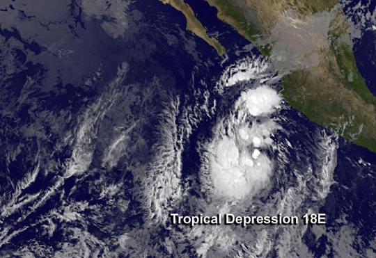
Two Satellites See New Eastern Pacific Tropical Depression
 The eighteenth tropical depression of the Eastern Pacific Ocean hurricane season formed early on the first day of November and is expected to become a tropical storm. NASA's TRMM satellite observed moderate rainfall in the storm and NOAA's GOES-West satellite captured a look at the cloud extent.
On Oct. 31 at 3:52 p.m. EDT NASA's Tropical Rainfall Measuring Mission satellite known as TRMM passed over the developing depression. TRMM data showed an area of moderate rainfall around the forming depression's center, where rain was falling at a rate of 1.18 inches/30 mm per hour. The highest thunderstorm cloud tops were around 6.2 miles/10 km high.
NOAA's GOES-West satellite captured an infrared image of the newly developed depression located about 305 miles/485 km southwest of Manzanillo, Mexico near 16.4 north and 108.0 west at 5 a.m. EDT on Nov. 1. TD18E had maximum sustained winds near 3 mph/55 kph and is expected to strengthen and become Tropical Storm Sonia. It was moving to the north at 7 mph.
NOAA's GOES-West satellite captured an infrared image of newborn Tropical Depression 18E in the Eastern Pacific on Nov. 1 at 8 a.m. EDT. Satellite data revealed that the surface circulation became better defined on Nov. 1.
There are several factors that forecasters at the National Hurricane Center are watching for over the weekend of Nov. 2 and 3. After 24 to 36 hours, a mid-level elongated area of low pressure or trough is expected to push the depression to the north and north-northeast bringing it toward land. Computer models show an increase in vertical wind shear from the southwest happening by Nov 4.
The eighteenth tropical depression of the Eastern Pacific Ocean hurricane season formed early on the first day of November and is expected to become a tropical storm. NASA's TRMM satellite observed moderate rainfall in the storm and NOAA's GOES-West satellite captured a look at the cloud extent.
On Oct. 31 at 3:52 p.m. EDT NASA's Tropical Rainfall Measuring Mission satellite known as TRMM passed over the developing depression. TRMM data showed an area of moderate rainfall around the forming depression's center, where rain was falling at a rate of 1.18 inches/30 mm per hour. The highest thunderstorm cloud tops were around 6.2 miles/10 km high.
NOAA's GOES-West satellite captured an infrared image of the newly developed depression located about 305 miles/485 km southwest of Manzanillo, Mexico near 16.4 north and 108.0 west at 5 a.m. EDT on Nov. 1. TD18E had maximum sustained winds near 3 mph/55 kph and is expected to strengthen and become Tropical Storm Sonia. It was moving to the north at 7 mph.
NOAA's GOES-West satellite captured an infrared image of newborn Tropical Depression 18E in the Eastern Pacific on Nov. 1 at 8 a.m. EDT. Satellite data revealed that the surface circulation became better defined on Nov. 1.
There are several factors that forecasters at the National Hurricane Center are watching for over the weekend of Nov. 2 and 3. After 24 to 36 hours, a mid-level elongated area of low pressure or trough is expected to push the depression to the north and north-northeast bringing it toward land. Computer models show an increase in vertical wind shear from the southwest happening by Nov 4.
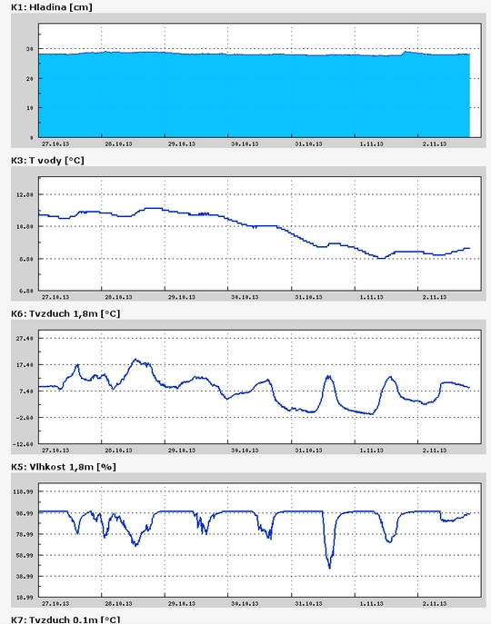
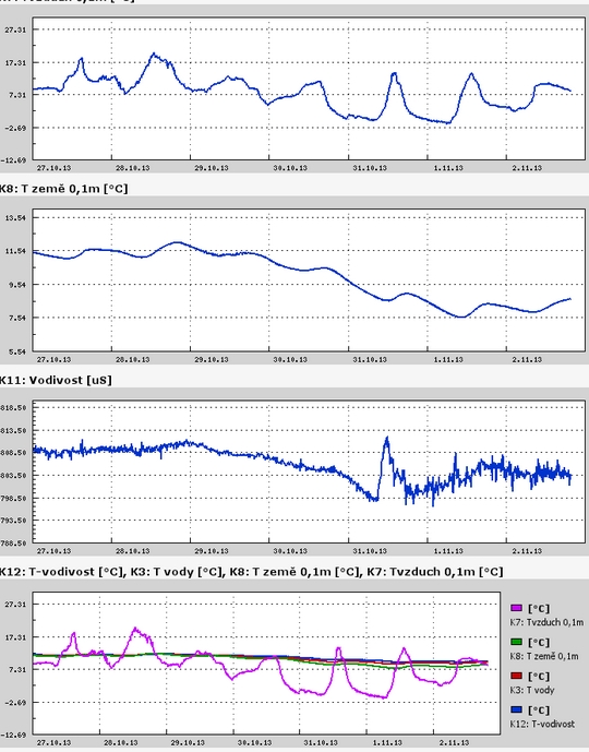
Teplota vzduchu a vody, vlhkost ,
 https://stanice.fiedler-magr.cz
Archiv
37_201336_2013
35_2013
34_2013
33_2013
32_2013
31_2013
30_2013
29_2013
28_2013
27_2013
26_2013
25_2013
24_2013
23_2013
22_2013
21_2013
20_2013
19_2013
18_2013
17_2013
16_2013
15_2013
14_2013
13_2013
12_2013
11_2013
10_2013
09_2013
08_2013
07_2013
06_2013
05_2013
04_2013
03_2013
02_2013
01_2013

 | Zemědělská 1/1665 613 00 Brno Budova D | Tel.: +420 545 133 350 Fax.: +420 545 212 044 |  |
 |