

Učit se znamená objevovat to, co už víš.
Konat znamená demonstrovat, že to to víš.
Učit druhé znamená připomínat jim, že to vědí stejně dobře jako ty.
Všichni jste zároveň žáci, praktikanti a učitelé.
Richard Bach
Konference
Konference v roce 2015
Konference v roce 2014
Konference v roce 2013
Konference v roce 2012
Konference v roce 2011


Polní laboratoř
NASA Catches Tropical Cyclone Lehar Over the Andaman Islands
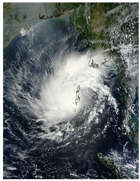 The Andaman Islands received an unwelcome visitor on November 25 in the form of Tropical Cyclone Lehar. NASA's Terra satellite captured a picture of the visitor as it was making its exit from the islands and into the Bay of Bengal.
Tropical Depression 05B formed off the west coast of the Malay Peninsula on November 23 and strengthened into Tropical Cyclone Lehar as it moved from the Andaman Sea over the Andaman Islands and is now working its way into the Bay of Bengal and toward India. The Andaman Islands are located in the eastern Bay of Bengal. Burma lies north and east of the island group and India lies to the west.
Tropical Cyclone Lehar was over the Andaman and Nicobar Islands at the time NASA's Terra satellite flew overhead and captured a visible image of the storm. On November 25, 2013 at 04:25 UTC/Nov. 24 11:25 p.m. EST, the Moderate Resolution Imaging Spectroradiometer or MODIS instrument that flies aboard Terra took a picture of the tropical cyclone as the eastern side of the storm covered the island. Most of Cyclone Lehar was west of the island in the Bay of Bengal, although the northeastern edge of the storm extended over west-central Burma, bringing clouds to Yangon, capital city of the Yangon region. By November 26, Lehar was bringing rainfall and gusty winds to the region.
At 1500 UTC/10 a.m. EST on November 25, Tropical Cyclone Lehar had maximum sustained winds near 65 knots/74.8 mph/120.4 kph, achieving hurricane-force. It was centered near 12.6 north and 90.6 east, about 550 nautical miles/633 miles/1,019 km southeast of Visakhapatnam, India. Lehar is moving away from Burma and toward the west-northwest at 7 knots/8 mph/12.9 kph. Lehar is generating 20-foot/6.0 meter high seas
Forecasters at the Joint Typhoon Warning Center expect that warm water temperatures and low wind shear will assist Lehar in intensifying as it moves in a west-northwesterly direction across the Bay of Bengal. Forecasters expect maximum sustained winds to peak near 100 knots/115.1 mph/185.2 kph before making landfall in eastern India.
As a result warnings are already in effect for India. Lehar's winds area expected to affect Northern Andhra Pradesh and southern Odisha by Wednesday, November 27.
The Andaman Islands received an unwelcome visitor on November 25 in the form of Tropical Cyclone Lehar. NASA's Terra satellite captured a picture of the visitor as it was making its exit from the islands and into the Bay of Bengal.
Tropical Depression 05B formed off the west coast of the Malay Peninsula on November 23 and strengthened into Tropical Cyclone Lehar as it moved from the Andaman Sea over the Andaman Islands and is now working its way into the Bay of Bengal and toward India. The Andaman Islands are located in the eastern Bay of Bengal. Burma lies north and east of the island group and India lies to the west.
Tropical Cyclone Lehar was over the Andaman and Nicobar Islands at the time NASA's Terra satellite flew overhead and captured a visible image of the storm. On November 25, 2013 at 04:25 UTC/Nov. 24 11:25 p.m. EST, the Moderate Resolution Imaging Spectroradiometer or MODIS instrument that flies aboard Terra took a picture of the tropical cyclone as the eastern side of the storm covered the island. Most of Cyclone Lehar was west of the island in the Bay of Bengal, although the northeastern edge of the storm extended over west-central Burma, bringing clouds to Yangon, capital city of the Yangon region. By November 26, Lehar was bringing rainfall and gusty winds to the region.
At 1500 UTC/10 a.m. EST on November 25, Tropical Cyclone Lehar had maximum sustained winds near 65 knots/74.8 mph/120.4 kph, achieving hurricane-force. It was centered near 12.6 north and 90.6 east, about 550 nautical miles/633 miles/1,019 km southeast of Visakhapatnam, India. Lehar is moving away from Burma and toward the west-northwest at 7 knots/8 mph/12.9 kph. Lehar is generating 20-foot/6.0 meter high seas
Forecasters at the Joint Typhoon Warning Center expect that warm water temperatures and low wind shear will assist Lehar in intensifying as it moves in a west-northwesterly direction across the Bay of Bengal. Forecasters expect maximum sustained winds to peak near 100 knots/115.1 mph/185.2 kph before making landfall in eastern India.
As a result warnings are already in effect for India. Lehar's winds area expected to affect Northern Andhra Pradesh and southern Odisha by Wednesday, November 27.
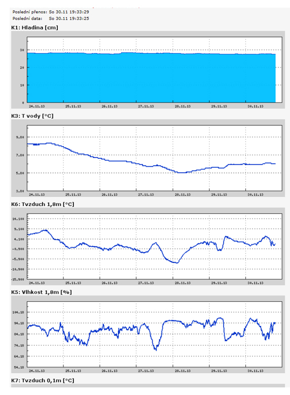
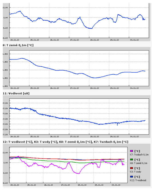
Teplota vzduchu a vody, vlhkost ,
 https://stanice.fiedler-magr.cz
Archiv
40_201339_2013
38_2013
37_2013
36_2013
35_2013
34_2013
33_2013
32_2013
31_2013
30_2013
29_2013
28_2013
27_2013
26_2013
25_2013
24_2013
23_2013
22_2013
21_2013
20_2013
19_2013
18_2013
17_2013
16_2013
15_2013
14_2013
13_2013
12_2013
11_2013
10_2013
09_2013
08_2013
07_2013
06_2013
05_2013
04_2013
03_2013
02_2013
01_2013

 | Zemědělská 1/1665 613 00 Brno Budova D | Tel.: +420 545 133 350 Fax.: +420 545 212 044 |  |
 |