

"Nejsmutnějším aspektem života v současné době je to, že věda shromažďuje poznatky rychleji, než společnost shromažďuje moudrost."
Isaac Asimov
Konference
Konference v roce 2015
Konference v roce 2014
Konference v roce 2013
Konference v roce 2012
Konference v roce 2011


Polní laboratoř

NASA Sees Rainfall from System 94S Over Australia's Arnhem Region
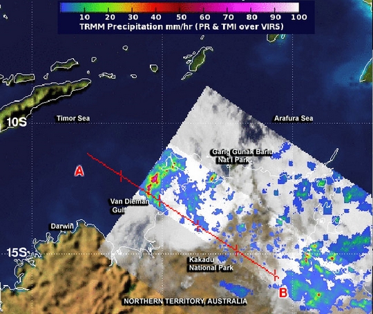 The low pressure area designated as System 94S has been trying to organize off the northern coast of Australia's Northern Territory for a couple of days. NASA's TRMM satellite passed overhead on January 14 and saw some areas of heavy rainfall as the low appears more organized.
NASA and the Japan Aerospace Exploration Agency's Tropical Rainfall Measuring Mission satellite known as TRMM measured the rainfall rates occurring in System 94S as it affected the northern coast of Australia's Northern Territory or NT, on January 14 at 0214 UTC/11:44 a.m. local time Darwin/Australia/Jan. 13, 9:14 p.m. EST. System 94S' rains are affecting the Arnhem Region of the Northern Territory.
TRMM measured the heaviest rainfall rates near 2 inches/50 mm per hour over the northeastern Van Dieman Gulf, and just off-shore in the northwestern Arnhem Region of the Northern Territory. TRMM data was used to estimate the heights of the thunderstorms that were dropping that heavy rain. Those storms were about 10 kilometers/6.2 miles high.TRMM data showed light to moderate rainfall from System 94S stretched from the Van Dieman Gulf east, over Gang Gunak Barlu National Park, and Kakadu National Park, and southeast over Flying Fox, NT on Route 24, Central Arnhem Road.The Australian Government Bureau of Meteorology for the Northern Territory issued a Severe Weather Warning on January 14 for residents in the Darwin-Daly, Arnhem, Roper-McArthur, Victoria River and Barkly Districts, including Darwin and the Tiwi Islands. Those areas can expect damaging winds and heavy rainfall from System 94S.The warning states that squalls with locally damaging wind gusts up to 95 kph/59 mph are expected along the Territory coastline tonight (Tuesday, Jan. 14) and during Wednesday, Jan. 15. For the full text of the warning, visit: http://www.bom.gov.au/cgi-bin/wrap_fwo.pl?IDD20040.txt.At 12:30 UTC/9:30 p.m. Darwin local time/7:30 a.m. EST on January 14, System 94S was located near latitude 13.7 south and longitude 131.3 east, about 150 kilometers/ 93.2 miles south-southeast of Darwin. System 94S is expected to move in a southwesterly direction, close to the coast near the border between the Northern Territory and Western Australia.Animated infrared satellite imagery showed there is also fragmented bands of thunderstorms associated with the low-level center, which appears to be developing slowly. System 94S' low-level center is moving over land, but computer modeling used by the Joint Typhoon Warning Center or JTWC showed that System 94S' center will re-emerge over water in the next day or two. So, the JTWC gives System 94S a medium chance for becoming a tropical depression in the next day.
The low pressure area designated as System 94S has been trying to organize off the northern coast of Australia's Northern Territory for a couple of days. NASA's TRMM satellite passed overhead on January 14 and saw some areas of heavy rainfall as the low appears more organized.
NASA and the Japan Aerospace Exploration Agency's Tropical Rainfall Measuring Mission satellite known as TRMM measured the rainfall rates occurring in System 94S as it affected the northern coast of Australia's Northern Territory or NT, on January 14 at 0214 UTC/11:44 a.m. local time Darwin/Australia/Jan. 13, 9:14 p.m. EST. System 94S' rains are affecting the Arnhem Region of the Northern Territory.
TRMM measured the heaviest rainfall rates near 2 inches/50 mm per hour over the northeastern Van Dieman Gulf, and just off-shore in the northwestern Arnhem Region of the Northern Territory. TRMM data was used to estimate the heights of the thunderstorms that were dropping that heavy rain. Those storms were about 10 kilometers/6.2 miles high.TRMM data showed light to moderate rainfall from System 94S stretched from the Van Dieman Gulf east, over Gang Gunak Barlu National Park, and Kakadu National Park, and southeast over Flying Fox, NT on Route 24, Central Arnhem Road.The Australian Government Bureau of Meteorology for the Northern Territory issued a Severe Weather Warning on January 14 for residents in the Darwin-Daly, Arnhem, Roper-McArthur, Victoria River and Barkly Districts, including Darwin and the Tiwi Islands. Those areas can expect damaging winds and heavy rainfall from System 94S.The warning states that squalls with locally damaging wind gusts up to 95 kph/59 mph are expected along the Territory coastline tonight (Tuesday, Jan. 14) and during Wednesday, Jan. 15. For the full text of the warning, visit: http://www.bom.gov.au/cgi-bin/wrap_fwo.pl?IDD20040.txt.At 12:30 UTC/9:30 p.m. Darwin local time/7:30 a.m. EST on January 14, System 94S was located near latitude 13.7 south and longitude 131.3 east, about 150 kilometers/ 93.2 miles south-southeast of Darwin. System 94S is expected to move in a southwesterly direction, close to the coast near the border between the Northern Territory and Western Australia.Animated infrared satellite imagery showed there is also fragmented bands of thunderstorms associated with the low-level center, which appears to be developing slowly. System 94S' low-level center is moving over land, but computer modeling used by the Joint Typhoon Warning Center or JTWC showed that System 94S' center will re-emerge over water in the next day or two. So, the JTWC gives System 94S a medium chance for becoming a tropical depression in the next day.
NASA Catches Development of Tropical Cyclone 09S in Southern Indian Ocean
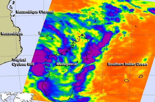 The ninth tropical cyclone of the Southern Indian Ocean season was born hours after NASA's Aqua satellite passed overhead and gathered important infrared data on the developing storm.
NASA's Aqua satellite passed over System 95S on January 15 at 21:59 UTC/4:59 p.m. EST and saw two large areas of powerful thunderstorms within the developing low pressure area. Thunderstorms with cloud top temperatures exceeding -63F/-52C indicated powerful uplift in the low pressure area.
System 95S consolidated and organized more by 1500 UTC/10 a.m. EST on January 16 to be classified as Tropical Cyclone 09S. At that time, 09S was centered near 20.2 south latitude and 43.4 east longitude, about 215 nautical miles/247.4 miles/398.2 km west-southwest of Antananarivo, Madagascar, and just off the west coast of Madagascar, over the southern Mozambique Channel. The channel is an area of water that lies between the island nation of Madagascar and the country of Mozambique on the African Continent. Tropical Cyclone 09S was moving to the southwest at 10 knots/11.5 mph/18.5 kph and had maximum sustained winds near 35 knots/40 mph/62 kph.
Forecasters at the Joint Typhoon Warning Center expect 09S to strengthen to 50 knots/57.5 mph/92.6 kph and turn to the northwest, bringing gusty winds and rainfall from southeastern to east-central Mozambique over the next several days. By January 21, Tropical Cyclone 09S is expected to make landfall in east central Mozambique near Quelimane
The ninth tropical cyclone of the Southern Indian Ocean season was born hours after NASA's Aqua satellite passed overhead and gathered important infrared data on the developing storm.
NASA's Aqua satellite passed over System 95S on January 15 at 21:59 UTC/4:59 p.m. EST and saw two large areas of powerful thunderstorms within the developing low pressure area. Thunderstorms with cloud top temperatures exceeding -63F/-52C indicated powerful uplift in the low pressure area.
System 95S consolidated and organized more by 1500 UTC/10 a.m. EST on January 16 to be classified as Tropical Cyclone 09S. At that time, 09S was centered near 20.2 south latitude and 43.4 east longitude, about 215 nautical miles/247.4 miles/398.2 km west-southwest of Antananarivo, Madagascar, and just off the west coast of Madagascar, over the southern Mozambique Channel. The channel is an area of water that lies between the island nation of Madagascar and the country of Mozambique on the African Continent. Tropical Cyclone 09S was moving to the southwest at 10 knots/11.5 mph/18.5 kph and had maximum sustained winds near 35 knots/40 mph/62 kph.
Forecasters at the Joint Typhoon Warning Center expect 09S to strengthen to 50 knots/57.5 mph/92.6 kph and turn to the northwest, bringing gusty winds and rainfall from southeastern to east-central Mozambique over the next several days. By January 21, Tropical Cyclone 09S is expected to make landfall in east central Mozambique near Quelimane
NASA Satellite Watches Southern Pacific Birth Tropical Cyclone June
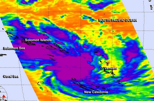 The tenth tropical cyclone of the Southern Pacific Ocean cyclone season was born today, January 17 as NASA's Aqua satellite captured infrared data on the storm as it became Tropical Storm June.
NASA's Aqua satellite passed over Tropical Cyclone June at 02:41 UTC. The Atmospheric Infrared Sounder or AIRS instrument captured infrared data and temperature information about June, and it was used to create a false-colored image at NASA's Jet Propulsion Laboratory in Pasadena, Calif. The AIRS image showed the center of June between the Solomon Islands to the northwest, New Caledonia to the southeast and Vanuatu to the east. Thunderstorms around the center and mostly over open waters were dropping heavy rainfall. AIRS data showed that those thunderstorms had cloud top temperatures in excess of -63F/-52C indicating they were high in the troposphere and powerful.
On June 17, a tropical cyclone Watch is in effect for Norfolk Island. Northern New Caledonia and the community of Thio are now on an Amber Alert, while the remainder of the territory is on Yellow Alert.
On January 17 at 1500 UTC/10 a.m. EST, the Joint Typhoon Warning Center or JTWC noted that June was centered near 18.8 south latitude and 163.0 east longitude, about 294 nautical miles/338.3 miles/544.5 km southeast of Noumea, New Caledonia.
June's maximum sustained winds were near 35 knots/40 mph/62 kph and the storm is expected to strengthen slightly over the next several days. The JTWC forecasts June to pass just west of New Caledonia on January 17 and 18.
Microwave satellite imagery from the AMSU-B instrument coupled with infrared satellite data showed that the low-level circulation center is slightly elongated. Strong bands of convective thunderstorms persist in the eastern quadrant of the storm.
June is in an area that has moderate vertical wind shear, blowing as high as 20 knots and is forecast to increase in two days, which is expected to prevent June from strengthening a lot more. By January 19 as June continues southward it will also run into cooler waters which will sap its strength and help transition the storm to an extra-tropical one.
Forecasters at JTWC noted that June is moving along the western edge of a subtropical ridge (elongated area) of high pressure located east of the tropical storm. With the ridge guiding the system, JTWC's forecast track takes a weakened June to the northwestern tip of New Zealand by January 20.
The tenth tropical cyclone of the Southern Pacific Ocean cyclone season was born today, January 17 as NASA's Aqua satellite captured infrared data on the storm as it became Tropical Storm June.
NASA's Aqua satellite passed over Tropical Cyclone June at 02:41 UTC. The Atmospheric Infrared Sounder or AIRS instrument captured infrared data and temperature information about June, and it was used to create a false-colored image at NASA's Jet Propulsion Laboratory in Pasadena, Calif. The AIRS image showed the center of June between the Solomon Islands to the northwest, New Caledonia to the southeast and Vanuatu to the east. Thunderstorms around the center and mostly over open waters were dropping heavy rainfall. AIRS data showed that those thunderstorms had cloud top temperatures in excess of -63F/-52C indicating they were high in the troposphere and powerful.
On June 17, a tropical cyclone Watch is in effect for Norfolk Island. Northern New Caledonia and the community of Thio are now on an Amber Alert, while the remainder of the territory is on Yellow Alert.
On January 17 at 1500 UTC/10 a.m. EST, the Joint Typhoon Warning Center or JTWC noted that June was centered near 18.8 south latitude and 163.0 east longitude, about 294 nautical miles/338.3 miles/544.5 km southeast of Noumea, New Caledonia.
June's maximum sustained winds were near 35 knots/40 mph/62 kph and the storm is expected to strengthen slightly over the next several days. The JTWC forecasts June to pass just west of New Caledonia on January 17 and 18.
Microwave satellite imagery from the AMSU-B instrument coupled with infrared satellite data showed that the low-level circulation center is slightly elongated. Strong bands of convective thunderstorms persist in the eastern quadrant of the storm.
June is in an area that has moderate vertical wind shear, blowing as high as 20 knots and is forecast to increase in two days, which is expected to prevent June from strengthening a lot more. By January 19 as June continues southward it will also run into cooler waters which will sap its strength and help transition the storm to an extra-tropical one.
Forecasters at JTWC noted that June is moving along the western edge of a subtropical ridge (elongated area) of high pressure located east of the tropical storm. With the ridge guiding the system, JTWC's forecast track takes a weakened June to the northwestern tip of New Zealand by January 20.
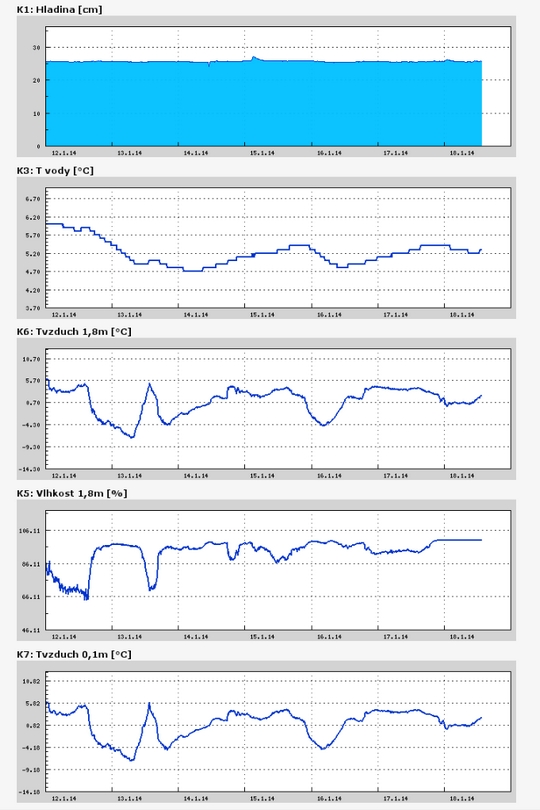
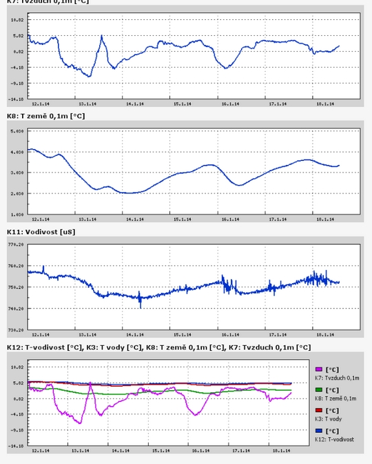
Teplota vzduchu a vody, vlhkost ,
 https://stanice.fiedler-magr.cz
Archiv
45_201344_2013
43_2013
42_2013
41_2013
40_2013
39_2013
38_2013
37_2013
36_2013
35_2013
34_2013
33_2013
32_2013
31_2013
30_2013
29_2013
28_2013
27_2013
26_2013
25_2013
24_2013
23_2013
22_2013
21_2013
20_2013
19_2013
18_2013
17_2013
16_2013
15_2013
14_2013
13_2013
12_2013
11_2013
10_2013
09_2013
08_2013
07_2013
06_2013
05_2013
04_2013
03_2013
02_2013
01_2013

 | Zemědělská 1/1665 613 00 Brno Budova D | Tel.: +420 545 133 350 Fax.: +420 545 212 044 |  |
 |