

Tajemství vládnutí spočívá totiž v tom, jak spojit víru ve vlastní neomylnost se schopností učit se z minulých chyb.
George Orwell
Konference
Konference v roce 2015
Konference v roce 2014
Konference v roce 2013
Konference v roce 2012
Konference v roce 2011


Polní laboratoř
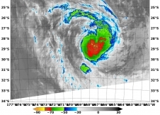
NASA Satellite Catches Last Glimpse of Kofi as a Tropical Cyclone
 Tropical Cyclone Kofi was becoming an extra-tropical storm on March 3 and NASA's Terra satellite captured its last hours as a tropical system.
The Moderate Resolution Imaging Spectroradiometer, or MODIS for short captured an image of Tropical Cyclone Kofi in the South Pacific Ocean on March 3 at 21:50 UTC before it made the total transition into an extra-tropical storm. MODIS is one of the instruments that flies aboard NASA's Terra satellite. The MODIS image showed that despite transitioning, Kofi still had good circulation. The highest and strongest thunderstorms appeared around the center of circulation and in a band west of the center.
Forecasters at the Joint Typhoon Warning Center or JTWC issued their final warning on Kofi on March 3 at 2100 UTC/4 p.m. EST. At that time, Kofi was centered near 30.5 south latitude and 164.3 west longitude, about 1,034 nautical miles/1,190 miles/1,915 km south-southeast of Pago Pago, American Samoa.
Kofi had almost completed extra-tropical transitioning and was speeding to the east-southeast at 28 knots/32.2 mph/51.8 kph. Kofi's maximum sustained winds were near 40 knots/46.0 mph/74.0 kph. JTWC expects Kofi to complete transition into an extra-tropical storm on March 4 and weaken over the coming days
Tropical Cyclone Kofi was becoming an extra-tropical storm on March 3 and NASA's Terra satellite captured its last hours as a tropical system.
The Moderate Resolution Imaging Spectroradiometer, or MODIS for short captured an image of Tropical Cyclone Kofi in the South Pacific Ocean on March 3 at 21:50 UTC before it made the total transition into an extra-tropical storm. MODIS is one of the instruments that flies aboard NASA's Terra satellite. The MODIS image showed that despite transitioning, Kofi still had good circulation. The highest and strongest thunderstorms appeared around the center of circulation and in a band west of the center.
Forecasters at the Joint Typhoon Warning Center or JTWC issued their final warning on Kofi on March 3 at 2100 UTC/4 p.m. EST. At that time, Kofi was centered near 30.5 south latitude and 164.3 west longitude, about 1,034 nautical miles/1,190 miles/1,915 km south-southeast of Pago Pago, American Samoa.
Kofi had almost completed extra-tropical transitioning and was speeding to the east-southeast at 28 knots/32.2 mph/51.8 kph. Kofi's maximum sustained winds were near 40 knots/46.0 mph/74.0 kph. JTWC expects Kofi to complete transition into an extra-tropical storm on March 4 and weaken over the coming days
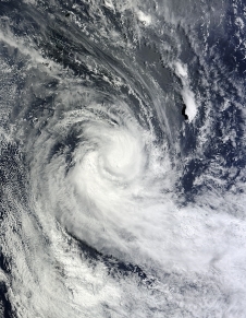
Mar. 03, 2014 - NASA Sees Strong Thunderstorms Around Tropical Cyclone Kofi
 NASA's Terra satellite passed over Tropical Cyclone Kofi in the Southwestern Pacific Ocean and captured an infrared image of the storm revealing powerful thunderstorms around center of circulation.
The Moderate Resolution Imaging Spectroradiometer or MODIS instrument that flies aboard NASA's Terra satellite captured an infrared image on March 3 at 09:55 UTC/4:55 a.m. EST. Cloud top temperatures were near -80C/-112F indicating very strong thunderstorms around the center.
At 0900 UTC/4 a.m. EST Tropical Storm Kofi had maximum sustained winds near 45 knots51.7 mph/83.3 kph. It was centered over open water near 27.6 south and 169.1 west, about 803 nautical miles/924 mph/1,487 km south of Pago Pago, American Samoa. Kofi was moving to the east-southeast at 20 knots/23 mph/37 kph. The Joint Typhoon Warning Center expects Kofi to continue moving southeast and is no threat to land.
Kofi is already undergoing extra-tropical transitioning, a process that should be complete by March 4.
NASA's Terra satellite passed over Tropical Cyclone Kofi in the Southwestern Pacific Ocean and captured an infrared image of the storm revealing powerful thunderstorms around center of circulation.
The Moderate Resolution Imaging Spectroradiometer or MODIS instrument that flies aboard NASA's Terra satellite captured an infrared image on March 3 at 09:55 UTC/4:55 a.m. EST. Cloud top temperatures were near -80C/-112F indicating very strong thunderstorms around the center.
At 0900 UTC/4 a.m. EST Tropical Storm Kofi had maximum sustained winds near 45 knots51.7 mph/83.3 kph. It was centered over open water near 27.6 south and 169.1 west, about 803 nautical miles/924 mph/1,487 km south of Pago Pago, American Samoa. Kofi was moving to the east-southeast at 20 knots/23 mph/37 kph. The Joint Typhoon Warning Center expects Kofi to continue moving southeast and is no threat to land.
Kofi is already undergoing extra-tropical transitioning, a process that should be complete by March 4.
Feb. 28, 2014 - Tropical Cyclone 16P Forms Near Fiji
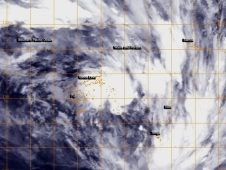 Tropical Cyclone 16P formed near Fiji after lingering in the region for several days as a tropical low pressure area. NOAA's GOES-West satellite captured an infrared image of the storm on February 28.
NOAA's GOES-West satellite image showed the center of Tropical Cyclone 16P to the northeast of Fiji and over Vanua Levu. Broken bands of thunderstorms wrapping from the north to the east and southeast reached Wallis and Fortuna, Samoa, Niue and Tonga.
At 0900 UTC/4 a.m. EST, Tropical Cyclone 16P was centered about 170 nautical miles/`95.6 miles/314.8 km northeast of Suva, Fiji near 16.1 south latitude and 179.5 west longitude. 16P had maximum sustained winds near 35 knots/40 mph/62 kph. It was moving to the east-southeast at 9 knots/10.3 mph/16.6 kph, and the Joint Typhoon Warning Center has forecast a more southeasterly track over the next several days.
According to Australia Network News, Tropical Cyclone 16P, as a low pressure area, had already dropped heavy rainfall over the main island of Viti Levu, including the capital Suva. Flooding has been reported in Viti Levu and continued to fall on February 28.
The Fiji Meteorological Service continued their Heavy Rain Warning for southern and eastern Vanua Levu, Taveuni and nearby smaller islands, Lau and Lomaiviti Group. The Fiji Met Service has forecast "periods of heavy rain and squally thunderstorms over southern and eastern Vanua Levu, Taveuni and nearby smaller islands: Lau and Lomaiviti group. Rain expected to ease over eastern and southern Vanua Levu from mid-morning and over Taveuni and nearby smaller islands, Lau and Lomaiviti group from evening." The warning also warned about the possibilities of flash flooding. For updates, visit: http://www.met.gov.fj.
The Joint Typhoon Warning Center has forecast Tropical Cyclone 16P to move in a southeasterly direction over the next five days.
Tropical Cyclone 16P formed near Fiji after lingering in the region for several days as a tropical low pressure area. NOAA's GOES-West satellite captured an infrared image of the storm on February 28.
NOAA's GOES-West satellite image showed the center of Tropical Cyclone 16P to the northeast of Fiji and over Vanua Levu. Broken bands of thunderstorms wrapping from the north to the east and southeast reached Wallis and Fortuna, Samoa, Niue and Tonga.
At 0900 UTC/4 a.m. EST, Tropical Cyclone 16P was centered about 170 nautical miles/`95.6 miles/314.8 km northeast of Suva, Fiji near 16.1 south latitude and 179.5 west longitude. 16P had maximum sustained winds near 35 knots/40 mph/62 kph. It was moving to the east-southeast at 9 knots/10.3 mph/16.6 kph, and the Joint Typhoon Warning Center has forecast a more southeasterly track over the next several days.
According to Australia Network News, Tropical Cyclone 16P, as a low pressure area, had already dropped heavy rainfall over the main island of Viti Levu, including the capital Suva. Flooding has been reported in Viti Levu and continued to fall on February 28.
The Fiji Meteorological Service continued their Heavy Rain Warning for southern and eastern Vanua Levu, Taveuni and nearby smaller islands, Lau and Lomaiviti Group. The Fiji Met Service has forecast "periods of heavy rain and squally thunderstorms over southern and eastern Vanua Levu, Taveuni and nearby smaller islands: Lau and Lomaiviti group. Rain expected to ease over eastern and southern Vanua Levu from mid-morning and over Taveuni and nearby smaller islands, Lau and Lomaiviti group from evening." The warning also warned about the possibilities of flash flooding. For updates, visit: http://www.met.gov.fj.
The Joint Typhoon Warning Center has forecast Tropical Cyclone 16P to move in a southeasterly direction over the next five days.
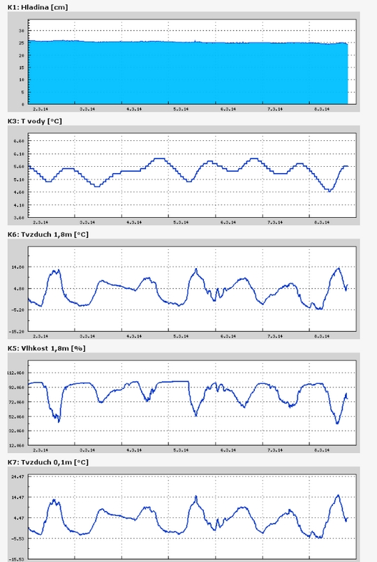
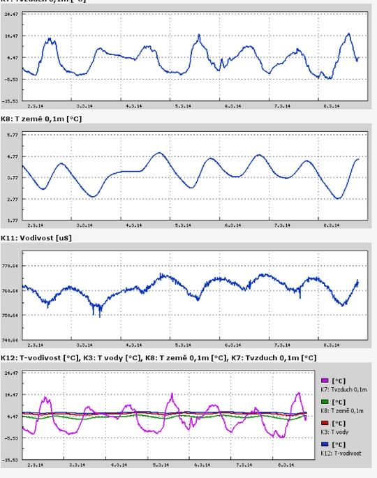
Teplota vzduchu a vody, vlhkost ,
 https://stanice.fiedler-magr.cz
Archiv
51_201350_2013
49_2013
48_2013
47_2013
46_2013
45_2013
44_2013
43_2013
42_2013
41_2013
40_2013
39_2013
38_2013
37_2013
36_2013
35_2013
34_2013
33_2013
32_2013
31_2013
30_2013
29_2013
28_2013
27_2013
26_2013
25_2013
24_2013
23_2013
22_2013
21_2013
20_2013
19_2013
18_2013
17_2013
16_2013
15_2013
14_2013
13_2013
12_2013
11_2013
10_2013
09_2013
08_2013
07_2013
06_2013
05_2013
04_2013
03_2013
02_2013
01_2013

 | Zemědělská 1/1665 613 00 Brno Budova D | Tel.: +420 545 133 350 Fax.: +420 545 212 044 |  |
 |