

Tajemství vládnutí spočívá totiž v tom, jak spojit víru ve vlastní neomylnost se schopností učit se z minulých chyb.
George Orwell
Konference
Konference v roce 2015
Konference v roce 2014
Konference v roce 2013
Konference v roce 2012
Konference v roce 2011


Polní laboratoř
NASA Sees Tropical Cyclone 15S Form in the Mozambique Channel
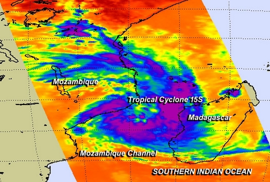 NASA's Aqua satellite passed over Tropical Cyclone 15S as it formed in the Mozambique Channel on Feb. 18 and the AIRS instrument aboard gathered infrared data on its cloud top temperatures and potential.
NASA's Aqua satellite passed over Tropical cyclone 15S on Feb. 18 at 10:53 a.m. EST. The Atmospheric Infrared Sounder or AIRS instrument captured infrared data on the tropical system that showed the highest cloud tops and strongest thunderstorms were in a band that stretched from the east to the south of the center. Cloud top temperatures were near -63F/-52C, indicating high, powerful thunderstorms with potential for heavy rainfall. The eastern-most edge was over western Madagascar and the southwestern extent reached Mozambique on the African mainland.
On February 18 at 1500 UTC/10 a.m. EST, Tropical Cyclone 15S had maximum sustained winds near 35 knots/40 mph/62 kph, making it a tropical storm. 15S was centered near 18.3 south and 40.3 east, about 375 nautical miles/431.5 miles/694.5 km west of Antananarivo, Madagascar. It was moving to the south at 5 knots/5.7 mph/9.2 kph and is expected to strengthen to hurricane-force over the next couple of days. It is generating 10 foot high waves in the Mozambique Channel.
Forecasters at the Joint Typhoon Warning Center expect 15S to drift south through the Mozambique Channel over the next couple of days and emerge in the Southern Indian Ocean in cooler waters.
NASA's Aqua satellite passed over Tropical Cyclone 15S as it formed in the Mozambique Channel on Feb. 18 and the AIRS instrument aboard gathered infrared data on its cloud top temperatures and potential.
NASA's Aqua satellite passed over Tropical cyclone 15S on Feb. 18 at 10:53 a.m. EST. The Atmospheric Infrared Sounder or AIRS instrument captured infrared data on the tropical system that showed the highest cloud tops and strongest thunderstorms were in a band that stretched from the east to the south of the center. Cloud top temperatures were near -63F/-52C, indicating high, powerful thunderstorms with potential for heavy rainfall. The eastern-most edge was over western Madagascar and the southwestern extent reached Mozambique on the African mainland.
On February 18 at 1500 UTC/10 a.m. EST, Tropical Cyclone 15S had maximum sustained winds near 35 knots/40 mph/62 kph, making it a tropical storm. 15S was centered near 18.3 south and 40.3 east, about 375 nautical miles/431.5 miles/694.5 km west of Antananarivo, Madagascar. It was moving to the south at 5 knots/5.7 mph/9.2 kph and is expected to strengthen to hurricane-force over the next couple of days. It is generating 10 foot high waves in the Mozambique Channel.
Forecasters at the Joint Typhoon Warning Center expect 15S to drift south through the Mozambique Channel over the next couple of days and emerge in the Southern Indian Ocean in cooler waters.
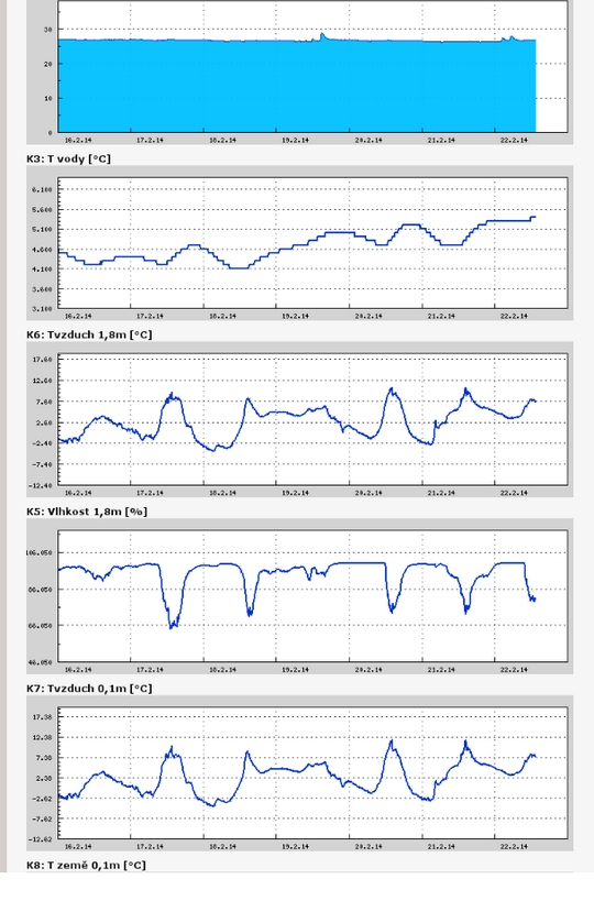
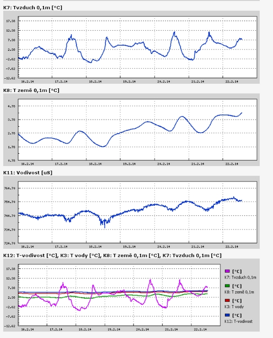
Teplota vzduchu a vody, vlhkost ,
 https://stanice.fiedler-magr.cz
Archiv
49_201348_2013
47_2013
46_2013
45_2013
44_2013
43_2013
42_2013
41_2013
40_2013
39_2013
38_2013
37_2013
36_2013
35_2013
34_2013
33_2013
32_2013
31_2013
30_2013
29_2013
28_2013
27_2013
26_2013
25_2013
24_2013
23_2013
22_2013
21_2013
20_2013
19_2013
18_2013
17_2013
16_2013
15_2013
14_2013
13_2013
12_2013
11_2013
10_2013
09_2013
08_2013
07_2013
06_2013
05_2013
04_2013
03_2013
02_2013
01_2013

 | Zemědělská 1/1665 613 00 Brno Budova D | Tel.: +420 545 133 350 Fax.: +420 545 212 044 |  |
 |