

Průměrný učitel vypráví. Dobrý učitel vysvětluje. Výborný učitel ukazuje. Nejlepší učitel inspiruje.
Charles Farrar Browne
Konference
Konference v roce 2015
Konference v roce 2014
Konference v roce 2013
Konference v roce 2012
Konference v roce 2011


Polní laboratoř
NASA Saw Rainfall Rates Increase Before Birth of Tropical Storm Faxai
 The Tropical Rainfall Measuring Mission or TRMM satellite passed over System 93W in the Northwestern Pacific Ocean and saw rainfall rates increasing on February 27 in the developing tropical low pressure area. On February 28, the low organized and consolidated resulting in the birth of Tropical Storm Faxai.
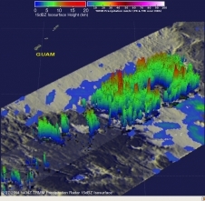
The TRMM satellite, managed by both NASA and the Japan Aerospace Exploration Agency passed over System 93W on February 27, 2014 at 1404 UTC/9:04 a.m. EST. Tropical cyclone development southeast of the island of Guam looked more likely with this pass. An analysis of rainfall derived from TRMM Microwave Imager (TMI) and Precipitation Radar (PR) data was created at NASA's Goddard Space Flight Center in Greenbelt, Md. when the data was overlaid on an enhanced infrared image from TRMM's Visible and InfraRed Scanner (VIRS) instrument. The analysis revealed that the rates in which rain was falling had increase to 107 mm/~4.2 inches per hour in some convective storms.
TRMM PR data was used to create a 3-D perspective of the developing tropical low pressure area. The 3-D image showed that convective activity had increased and some towering thunderstorms in the area were reaching altitudes of up to 15.5km/~9.6 miles. System 93W formed into Tropical Depression 03W early on February 28. By 1500 UTC/10 a.m. EST, the depression strengthened into a tropical storm and was renamed Faxai. At that time, Faxai's maximum sustained winds were near 35 knots/40 mph/62 kph. It was located near 9.0 north latitude and 149.0 east longitude, about 372 nautical miles/428.1 miles/688.9 km southeast of Andersen Air Force Base. Faxai is moving to the north-northeast at 3 knots/3.4 mph/5.5 kph.
The Joint Typhoon Warning Center forecast calls for Faxai to meander in the same area for a day before taking a northerly track. By March 3, Faxai is expected to intensify to hurricane- force over open waters of the Northwestern Pacific Ocean.
The Tropical Rainfall Measuring Mission or TRMM satellite passed over System 93W in the Northwestern Pacific Ocean and saw rainfall rates increasing on February 27 in the developing tropical low pressure area. On February 28, the low organized and consolidated resulting in the birth of Tropical Storm Faxai.
The TRMM satellite, managed by both NASA and the Japan Aerospace Exploration Agency passed over System 93W on February 27, 2014 at 1404 UTC/9:04 a.m. EST. Tropical cyclone development southeast of the island of Guam looked more likely with this pass. An analysis of rainfall derived from TRMM Microwave Imager (TMI) and Precipitation Radar (PR) data was created at NASA's Goddard Space Flight Center in Greenbelt, Md. when the data was overlaid on an enhanced infrared image from TRMM's Visible and InfraRed Scanner (VIRS) instrument. The analysis revealed that the rates in which rain was falling had increase to 107 mm/~4.2 inches per hour in some convective storms.
TRMM PR data was used to create a 3-D perspective of the developing tropical low pressure area. The 3-D image showed that convective activity had increased and some towering thunderstorms in the area were reaching altitudes of up to 15.5km/~9.6 miles. System 93W formed into Tropical Depression 03W early on February 28. By 1500 UTC/10 a.m. EST, the depression strengthened into a tropical storm and was renamed Faxai. At that time, Faxai's maximum sustained winds were near 35 knots/40 mph/62 kph. It was located near 9.0 north latitude and 149.0 east longitude, about 372 nautical miles/428.1 miles/688.9 km southeast of Andersen Air Force Base. Faxai is moving to the north-northeast at 3 knots/3.4 mph/5.5 kph.
The Joint Typhoon Warning Center forecast calls for Faxai to meander in the same area for a day before taking a northerly track. By March 3, Faxai is expected to intensify to hurricane- force over open waters of the Northwestern Pacific Ocean.
Tropical Cyclone 16P Forms Near Fiji
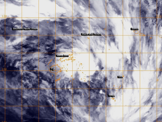 Tropical Cyclone 16P formed near Fiji after lingering in the region for several days as a tropical low pressure area. NOAA's GOES-West satellite captured an infrared image of the storm on February 28.
NOAA's GOES-West satellite image showed the center of Tropical Cyclone 16P to the northeast of Fiji and over Vanua Levu. Broken bands of thunderstorms wrapping from the north to the east and southeast reached Wallis and Fortuna, Samoa, Niue and Tonga.
At 0900 UTC/4 a.m. EST, Tropical Cyclone 16P was centered about 170 nautical miles/`95.6 miles/314.8 km northeast of Suva, Fiji near 16.1 south latitude and 179.5 west longitude. 16P had maximum sustained winds near 35 knots/40 mph/62 kph. It was moving to the east-southeast at 9 knots/10.3 mph/16.6 kph, and the Joint Typhoon Warning Center has forecast a more southeasterly track over the next several days. According to Australia Network News, Tropical Cyclone 16P, as a low pressure area, had already dropped heavy rainfall over the main island of Viti Levu, including the capital Suva. Flooding has been reported in Viti Levu and continued to fall on February 28.
The Fiji Meteorological Service continued their Heavy Rain Warning for southern and eastern Vanua Levu, Taveuni and nearby smaller islands, Lau and Lomaiviti Group. The Fiji Met Service has forecast "periods of heavy rain and squally thunderstorms over southern and eastern Vanua Levu, Taveuni and nearby smaller islands: Lau and Lomaiviti group. Rain expected to ease over eastern and southern Vanua Levu from mid-morning and over Taveuni and nearby smaller islands, Lau and Lomaiviti group from evening." The warning also warned about the possibilities of flash flooding. For updates, visit: http://www.met.gov.fj.
The Joint Typhoon Warning Center has forecast Tropical Cyclone 16P to move in a southeasterly direction over the next five days.
Tropical Cyclone 16P formed near Fiji after lingering in the region for several days as a tropical low pressure area. NOAA's GOES-West satellite captured an infrared image of the storm on February 28.
NOAA's GOES-West satellite image showed the center of Tropical Cyclone 16P to the northeast of Fiji and over Vanua Levu. Broken bands of thunderstorms wrapping from the north to the east and southeast reached Wallis and Fortuna, Samoa, Niue and Tonga.
At 0900 UTC/4 a.m. EST, Tropical Cyclone 16P was centered about 170 nautical miles/`95.6 miles/314.8 km northeast of Suva, Fiji near 16.1 south latitude and 179.5 west longitude. 16P had maximum sustained winds near 35 knots/40 mph/62 kph. It was moving to the east-southeast at 9 knots/10.3 mph/16.6 kph, and the Joint Typhoon Warning Center has forecast a more southeasterly track over the next several days. According to Australia Network News, Tropical Cyclone 16P, as a low pressure area, had already dropped heavy rainfall over the main island of Viti Levu, including the capital Suva. Flooding has been reported in Viti Levu and continued to fall on February 28.
The Fiji Meteorological Service continued their Heavy Rain Warning for southern and eastern Vanua Levu, Taveuni and nearby smaller islands, Lau and Lomaiviti Group. The Fiji Met Service has forecast "periods of heavy rain and squally thunderstorms over southern and eastern Vanua Levu, Taveuni and nearby smaller islands: Lau and Lomaiviti group. Rain expected to ease over eastern and southern Vanua Levu from mid-morning and over Taveuni and nearby smaller islands, Lau and Lomaiviti group from evening." The warning also warned about the possibilities of flash flooding. For updates, visit: http://www.met.gov.fj.
The Joint Typhoon Warning Center has forecast Tropical Cyclone 16P to move in a southeasterly direction over the next five days.
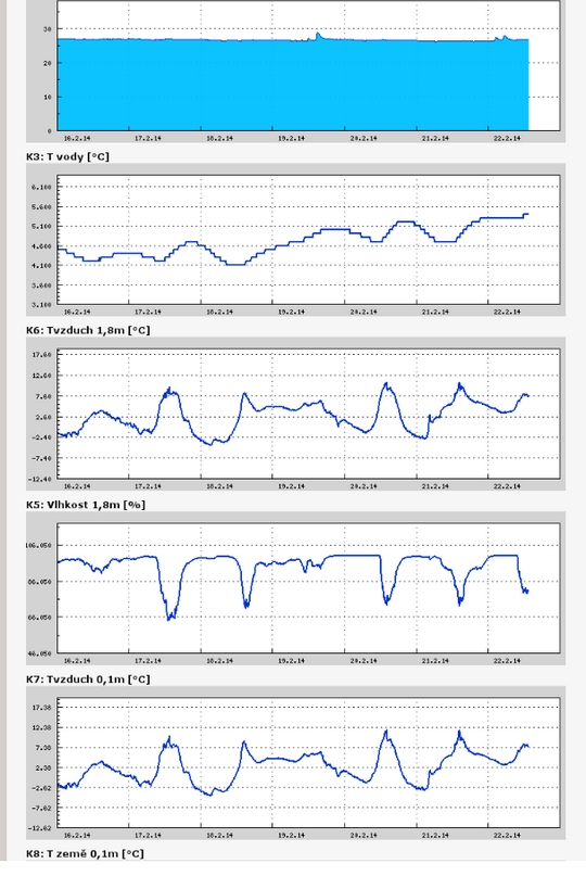
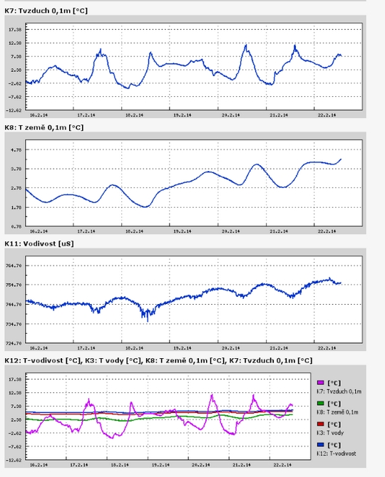
Teplota vzduchu a vody, vlhkost ,
 https://stanice.fiedler-magr.cz
Archiv
50_201349_2013
48_2013
47_2013
46_2013
45_2013
44_2013
43_2013
42_2013
41_2013
40_2013
39_2013
38_2013
37_2013
36_2013
35_2013
34_2013
33_2013
32_2013
31_2013
30_2013
29_2013
28_2013
27_2013
26_2013
25_2013
24_2013
23_2013
22_2013
21_2013
20_2013
19_2013
18_2013
17_2013
16_2013
15_2013
14_2013
13_2013
12_2013
11_2013
10_2013
09_2013
08_2013
07_2013
06_2013
05_2013
04_2013
03_2013
02_2013
01_2013

 | Zemědělská 1/1665 613 00 Brno Budova D | Tel.: +420 545 133 350 Fax.: +420 545 212 044 |  |
 |