

Účelem vzdělání není zaplnit mysl, ale otevřít ji. Čím více poznatků si osvojíme, tím víc si uvědomíme, co ještě neznáme.
Konference
Konference v roce 2015
Konference v roce 2014
Konference v roce 2013
Konference v roce 2012
Konference v roce 2011


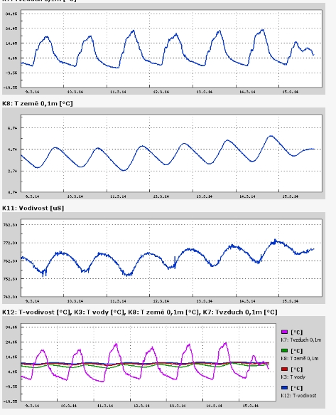
Polní laboratoř
Gillian and Hadi Spell Double Tropical Trouble Around Queensland
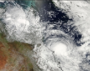 On Friday, March 7 there were two tropical lows located east and west of Queensland, Australia. Those lows organized and intensified into Tropical Cyclone Gillian and Hadi and were caught together in one amazing image from NASA's Aqua satellite. While Gillian has already made one landfall and is expected to make another, Hadi is turning tail and running from the mainland.
NASA's Aqua satellite passed over Queensland on March 10 at 04:00 UTC and the Moderate Resolution Imaging Spectroradiometer instrument known as MODIS captured Tropical Cyclones Gillian in the Gulf of Carpentaria, just west of Queensland's York Peninsula, and Hadi in the Coral Sea, east of Queensland.
On March 10 at 0300 UTC, Tropical Cyclone Gillian, formerly known as the low pressure area "System 98P" had maximum sustained winds near 35 knots/40 mph/62 kph. It was located about 230 nautical miles northeast of Mornington Island. Gillian is moving to the southeast at 5 knots/5.7 mph/9.2 kph, but is expected to re-curve to the southwest.
The Joint Typhoon Warning Center or JTWC noted that animated multi-spectral satellite imagery and radar from Weipa showed that the center made landfall in the northwestern coast of the York Peninsula. Gillian's center is also being battered by moderate northeasterly vertical wind shear, which is preventing any further intensification, but that's expected to change as Gillian turns back toward the Gulf. The JTWC expects Gillian to re-emerge in the Gulf of Carpentaria and head in a southwesterly direction, passing west of Mornington Island (located in the southern Gulf). JTWC forecasts Gillian to make its second and final landfall on the mainland near the Northern Territory/Queensland border on March 13.
The Australian Bureau of Meteorology noted on March 10, that residents from Burketown to the Queensland / Northern Territory border, including Mornington Island and Sweers Island should consider what action they will need to take if the cyclone threat increases.
Tropical Cyclone Hadi, formerly tropical low pressure area "System 96P" lingered off the coast of eastern Queensland near Willis Island on March 8 and 9 and is now being pushed northeast and out to sea.
On March 10 at 0900 UTC/5 a.m. EDT, Tropical Cyclone Hadi had maximum sustained winds near 35 knots/40 mph/62 kph. It was located about 176 nautical miles east-southeast of Willis Island, near 18.8 south and 151.3 east. Hadi was moving slowly to the east-southeast at 4 knots/4.6 mph/7.4 kph.
Satellite imagery showed moderate to strong vertical wind shear, between 20 and 30 knots/23.0 and 34.5 mph / 37.0 and 55.5 kph pushed the strongest thunderstorms south of the center of circulation. The JTWC expects Hadi to strengthen to 55 knots/63.2 mph/101.9 kph as it tracks to the northeast over the next several days.
For updates on watches and warnings in Australia, visit the Australian Bureau of Meteorology's website: http://www.bom.gov.au/cyclone/.
On Friday, March 7 there were two tropical lows located east and west of Queensland, Australia. Those lows organized and intensified into Tropical Cyclone Gillian and Hadi and were caught together in one amazing image from NASA's Aqua satellite. While Gillian has already made one landfall and is expected to make another, Hadi is turning tail and running from the mainland.
NASA's Aqua satellite passed over Queensland on March 10 at 04:00 UTC and the Moderate Resolution Imaging Spectroradiometer instrument known as MODIS captured Tropical Cyclones Gillian in the Gulf of Carpentaria, just west of Queensland's York Peninsula, and Hadi in the Coral Sea, east of Queensland.
On March 10 at 0300 UTC, Tropical Cyclone Gillian, formerly known as the low pressure area "System 98P" had maximum sustained winds near 35 knots/40 mph/62 kph. It was located about 230 nautical miles northeast of Mornington Island. Gillian is moving to the southeast at 5 knots/5.7 mph/9.2 kph, but is expected to re-curve to the southwest.
The Joint Typhoon Warning Center or JTWC noted that animated multi-spectral satellite imagery and radar from Weipa showed that the center made landfall in the northwestern coast of the York Peninsula. Gillian's center is also being battered by moderate northeasterly vertical wind shear, which is preventing any further intensification, but that's expected to change as Gillian turns back toward the Gulf. The JTWC expects Gillian to re-emerge in the Gulf of Carpentaria and head in a southwesterly direction, passing west of Mornington Island (located in the southern Gulf). JTWC forecasts Gillian to make its second and final landfall on the mainland near the Northern Territory/Queensland border on March 13.
The Australian Bureau of Meteorology noted on March 10, that residents from Burketown to the Queensland / Northern Territory border, including Mornington Island and Sweers Island should consider what action they will need to take if the cyclone threat increases.
Tropical Cyclone Hadi, formerly tropical low pressure area "System 96P" lingered off the coast of eastern Queensland near Willis Island on March 8 and 9 and is now being pushed northeast and out to sea.
On March 10 at 0900 UTC/5 a.m. EDT, Tropical Cyclone Hadi had maximum sustained winds near 35 knots/40 mph/62 kph. It was located about 176 nautical miles east-southeast of Willis Island, near 18.8 south and 151.3 east. Hadi was moving slowly to the east-southeast at 4 knots/4.6 mph/7.4 kph.
Satellite imagery showed moderate to strong vertical wind shear, between 20 and 30 knots/23.0 and 34.5 mph / 37.0 and 55.5 kph pushed the strongest thunderstorms south of the center of circulation. The JTWC expects Hadi to strengthen to 55 knots/63.2 mph/101.9 kph as it tracks to the northeast over the next several days.
For updates on watches and warnings in Australia, visit the Australian Bureau of Meteorology's website: http://www.bom.gov.au/cyclone/.
Mar. 07, 2014 - NASA Satellites See Double Tropical Trouble for Queensland, Australia
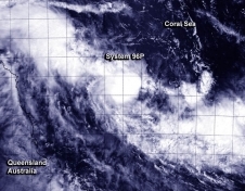 There are two developing areas of tropical low pressure that lie east and west of Queensland, Australia. System 96P and System 98P, respectively. The MODIS instrument that flies aboard both NASA's Aqua and Terra satellites captured images of both tropical trouble-makers as each satellite passed overhead on March 7.
In the Coral Sea, part of the Southwestern Pacific Ocean, System 96P was just 125 nautical miles/143.8 miles/231.5 km north-northeast of Willis Island, Australia. It was centered near 14.3 south latitude and 150.6 east longitude. System 96P is moving in south-southwesterly direction toward Willis Island and the Queensland mainland. As a result, a Cyclone Watch is in effect for coastal areas from Cairns to Mackay.
There are two developing areas of tropical low pressure that lie east and west of Queensland, Australia. System 96P and System 98P, respectively. The MODIS instrument that flies aboard both NASA's Aqua and Terra satellites captured images of both tropical trouble-makers as each satellite passed overhead on March 7.
In the Coral Sea, part of the Southwestern Pacific Ocean, System 96P was just 125 nautical miles/143.8 miles/231.5 km north-northeast of Willis Island, Australia. It was centered near 14.3 south latitude and 150.6 east longitude. System 96P is moving in south-southwesterly direction toward Willis Island and the Queensland mainland. As a result, a Cyclone Watch is in effect for coastal areas from Cairns to Mackay.
NASA Satellites Eye Troublesome Tropical Cyclone Lusi
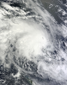 Tropical Cyclone Lusi has spawned warnings and watches in the Solomon Islands, Vanuatu, and New Zealand as it moves through the South Pacific Ocean. NASA's Terra and Aqua satellites provided visible and infrared views of the storm that revealed it has become better organized.
NASA's Terra satellite captured a visible image of Tropical Cyclone Lusi over Vanuatu on March 9 at 23:30 UTC. The image showed towering thunderstorms surrounded the center and northwestern quadrants of the storm.
The next day at 02:17 UTC, NASA's Aqua satellite passed over Lusi and captured infrared data on the storm that showed the thunderstorms rose high into the troposphere. The strongest thunderstorms had cloud top temperatures as cold as -63F/-52C. Multispectral satellite imagery showed that Lusi continued to consolidate and strong thunderstorms continue to develop. Those thunderstorms are wrapping into the center of circulation.
NASA and JAXA's Tropical Rainfall Measuring Mission satellite provided a microwave look at Lusi at 05:31 UTC/1:31 a.m. EST and showed the system continues to consolidate. TRMM data showed bands of strong thunderstorms had wrapped tightly around the center, and that the bulk of the deep convection is within the storm's northwestern quadrant.
Lusi has spawned several watches and warnings. In the Solomon Islands a tropical cyclone watch is in effect for Temotu, Makira, Rennell and Bellona, as well as the southern Guadalcanal and Malaita provinces.
In Vanuatu, gale force winds were expected to continue to affect Torba, Sanma, Penama and Malampa Provinces on March 10 and 11 as the storm pushes south. The Vanuatu Meteorological Service expects very rough seas and heavy swells throughout Vanuatu. They noted that heavy rainfall and flooding are also expected over low lying areas and areas close to river banks on March 10. For further updates from the Vanuatu Meteorological Services, visit: http://www.meteo.gov.vu.
Farther south, New Zealand is already anticipating effects from Lusi. The Met Service of New Zealand noted in their discussion on March 10, that once Lusi moves closer "it could bring a spell of wet and windy weather especially to parts of northern New Zealand by the weekend." For further updates from the New Zealand Met Service, visit: http://www.metservice.com/.
Tropical Cyclone Lusi has spawned warnings and watches in the Solomon Islands, Vanuatu, and New Zealand as it moves through the South Pacific Ocean. NASA's Terra and Aqua satellites provided visible and infrared views of the storm that revealed it has become better organized.
NASA's Terra satellite captured a visible image of Tropical Cyclone Lusi over Vanuatu on March 9 at 23:30 UTC. The image showed towering thunderstorms surrounded the center and northwestern quadrants of the storm.
The next day at 02:17 UTC, NASA's Aqua satellite passed over Lusi and captured infrared data on the storm that showed the thunderstorms rose high into the troposphere. The strongest thunderstorms had cloud top temperatures as cold as -63F/-52C. Multispectral satellite imagery showed that Lusi continued to consolidate and strong thunderstorms continue to develop. Those thunderstorms are wrapping into the center of circulation.
NASA and JAXA's Tropical Rainfall Measuring Mission satellite provided a microwave look at Lusi at 05:31 UTC/1:31 a.m. EST and showed the system continues to consolidate. TRMM data showed bands of strong thunderstorms had wrapped tightly around the center, and that the bulk of the deep convection is within the storm's northwestern quadrant.
Lusi has spawned several watches and warnings. In the Solomon Islands a tropical cyclone watch is in effect for Temotu, Makira, Rennell and Bellona, as well as the southern Guadalcanal and Malaita provinces.
In Vanuatu, gale force winds were expected to continue to affect Torba, Sanma, Penama and Malampa Provinces on March 10 and 11 as the storm pushes south. The Vanuatu Meteorological Service expects very rough seas and heavy swells throughout Vanuatu. They noted that heavy rainfall and flooding are also expected over low lying areas and areas close to river banks on March 10. For further updates from the Vanuatu Meteorological Services, visit: http://www.meteo.gov.vu.
Farther south, New Zealand is already anticipating effects from Lusi. The Met Service of New Zealand noted in their discussion on March 10, that once Lusi moves closer "it could bring a spell of wet and windy weather especially to parts of northern New Zealand by the weekend." For further updates from the New Zealand Met Service, visit: http://www.metservice.com/.
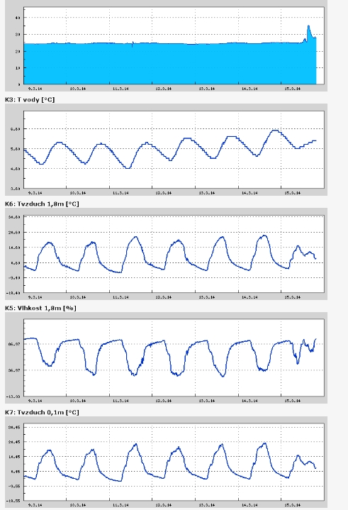
Teplota vzduchu a vody, vlhkost ,
 https://stanice.fiedler-magr.cz
Archiv
52_201351_2013
50_2013
49_2013
48_2013
47_2013
46_2013
45_2013
44_2013
43_2013
42_2013
41_2013
40_2013
39_2013
38_2013
37_2013
36_2013
35_2013
34_2013
33_2013
32_2013
31_2013
30_2013
29_2013
28_2013
27_2013
26_2013
25_2013
24_2013
23_2013
22_2013
21_2013
20_2013
19_2013
18_2013
17_2013
16_2013
15_2013
14_2013
13_2013
12_2013
11_2013
10_2013
09_2013
08_2013
07_2013
06_2013
05_2013
04_2013
03_2013
02_2013
01_2013

 | Zemědělská 1/1665 613 00 Brno Budova D | Tel.: +420 545 133 350 Fax.: +420 545 212 044 |  |
 |