

Je hanba, že se někdo dovede namáhat po mnoho let, aby se stal dobrým lékařem, obhájcem, učitelem nebo geometrem, a přitom není ochoten namáhat se příslušně dlouhý čas, aby se stal dobrým člověkem.
Galénos z Pergamu
Konference
Konference v roce 2015
Konference v roce 2014
Konference v roce 2013
Konference v roce 2012
Konference v roce 2011


Polní laboratoř
Satellite Sees Newborn So. Pacific Tropical Storm Mike
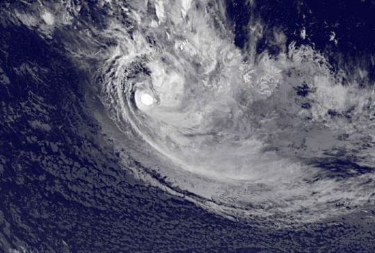 NOAA's GOES-West satellite caught the birth of Tropical Storm Mike in the Southern Pacific Ocean on March 19. Mike's formation has generated warnings for the Southern Cook Islands.
NOAA's GOES-West or GOES-15 satellite captured an infrared image of newborn Tropical Storm Mike in the Southwestern Pacific Ocean on March 19 at 1200 UTC/8 a.m. EDT. Mike appeared to be a compact, rounded tropical storm with bands of thunderstorms wrapping into it. NOAA's GOES-West satellite sits in a fixed orbit in space capturing visible and infrared imagery of all weather over the western U.S. and
Pacific Ocean.
To create a GOES image NASA/NOAA's GOES Project at NASA's Goddard Space Flight Center in Greenbelt, Md. uses cloud data from NOAA's GOES-East satellite and overlays it on a true-color image of land and ocean created by data from the Moderate Resolution Imaging Spectroradiometer, or MODIS, instrument that flies aboard NASA's Aqua and Terra satellites. Together, those data create the picture of the weather over the Pacific Ocean and Tropical Cyclone Mike's location.
According to the Joint Typhoon Warning Center or JTWC, animated infrared satellite imagery showed that the consolidated low level circulation center has persistent central convection (developing thunderstorms) and broken displaced convection to the northwest and southeast of the center.
On March 19 at 0900 UTC/5 a.m. EDT, Tropical Cyclone Mike was located near 20.5 south latitude and 159.3 west longitude. That's about 751 nautical miles/864.2 miles/1,391 miles east-southeast of Pago Pago, American Samoa. Mike was moving to the south-southeast at a speedy 24 knots/27.6 mph/44.4 kph. Mike's maximum sustained winds were near 35 knots/40 mph/62 kph.
JTWC noted that Mike is a threat to the Cook Islands. As a result, there are warnings in effect for the Southern Cook Islands. A gale warning is in effect for Rarotonga, Aitutaki, Manuae, Takutea, Atiu, Matiaro, Mauke and Mangaia.
JTWC forecasters expect Mike to move quickly to the south-southeast and strengthen to 45 knots/51.7 mph/83.3 kph before running into conditions that will make it extra-tropical in two days.
NOAA's GOES-West satellite caught the birth of Tropical Storm Mike in the Southern Pacific Ocean on March 19. Mike's formation has generated warnings for the Southern Cook Islands.
NOAA's GOES-West or GOES-15 satellite captured an infrared image of newborn Tropical Storm Mike in the Southwestern Pacific Ocean on March 19 at 1200 UTC/8 a.m. EDT. Mike appeared to be a compact, rounded tropical storm with bands of thunderstorms wrapping into it. NOAA's GOES-West satellite sits in a fixed orbit in space capturing visible and infrared imagery of all weather over the western U.S. and
Pacific Ocean.
To create a GOES image NASA/NOAA's GOES Project at NASA's Goddard Space Flight Center in Greenbelt, Md. uses cloud data from NOAA's GOES-East satellite and overlays it on a true-color image of land and ocean created by data from the Moderate Resolution Imaging Spectroradiometer, or MODIS, instrument that flies aboard NASA's Aqua and Terra satellites. Together, those data create the picture of the weather over the Pacific Ocean and Tropical Cyclone Mike's location.
According to the Joint Typhoon Warning Center or JTWC, animated infrared satellite imagery showed that the consolidated low level circulation center has persistent central convection (developing thunderstorms) and broken displaced convection to the northwest and southeast of the center.
On March 19 at 0900 UTC/5 a.m. EDT, Tropical Cyclone Mike was located near 20.5 south latitude and 159.3 west longitude. That's about 751 nautical miles/864.2 miles/1,391 miles east-southeast of Pago Pago, American Samoa. Mike was moving to the south-southeast at a speedy 24 knots/27.6 mph/44.4 kph. Mike's maximum sustained winds were near 35 knots/40 mph/62 kph.
JTWC noted that Mike is a threat to the Cook Islands. As a result, there are warnings in effect for the Southern Cook Islands. A gale warning is in effect for Rarotonga, Aitutaki, Manuae, Takutea, Atiu, Matiaro, Mauke and Mangaia.
JTWC forecasters expect Mike to move quickly to the south-southeast and strengthen to 45 knots/51.7 mph/83.3 kph before running into conditions that will make it extra-tropical in two days.

NASA's Aqua Satellite Sees Tropical System 94W Affecting Philippines
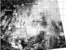 The tropical low pressure area centered just east of the southern Philippines appeared more organized on visible imagery from NASA's Aqua satellite on March 21. System 94W appears to be developing and the Philippine authorities have already issued warnings on the system locally designated as "Caloy."
The MODIS instrument (Moderate Resolution Imaging Spectroradiometer) that flies aboard NASA's Aqua satellite captured a visible image of System 94W coming together east of the southern Philippines on March 21 at 5:25 UTC/1:25 a.m. EDT. The image revealed a circulation with the center over the open waters of the Northwestern Pacific Ocean. The image showed bands of thunderstorms from System 94W's western quadrant was draped over the eastern Mindanao region (southern area) of the Philippines and bands of thunderstorms from the storm were over the waters of the Northwestern Pacific Ocean.
Warnings were posted by the Philippine Atmospheric, Geophysical and Astronomical Services Administration (PAGASA) on March 21 at 5 p.m. Signal No. 1 is in effect for parts of the Visayas and Mindanao regions of the Philippines today, March 21.
Signal No. 1 means that sustained winds of 18.6-37.2 mph/30-60 kph may be expected in at least 36 hours. In Visayas, those areas under Signal No. 1 include: Southern Leyte, Bohol, Siquijor, Southern Cebu, the southern part of Negros Occidental and the southern part of Negros Oriental.
In Mindanao, Signal No. 1 is in effect for Southern Leyte, Bohol, Siquijor, Southern Cebu, the southern part of Negros Occidental, and the southern part of Negros Oriental. For additional updates from PAGASA, please visit: http://www.pagasa.dost.gov.ph//
On March 21 at 5 p.m. local time, PAGASA noted that the center of System 94W was located near 8.9 north latitude and 127.8 east longitude, about 310 km/192.6 miles northeast of Davao City or at 170 km/105.6 miles East Northeast of Hinatuan, Surigao del Sur.
The Joint Typhoon Warning Center gives System 94W a high chance for developing into a tropical depression in the next day. Meanwhile, PAGASA expects the low to move to the west-northwest over the next couple of days and cross the southern Philippines.
The tropical low pressure area centered just east of the southern Philippines appeared more organized on visible imagery from NASA's Aqua satellite on March 21. System 94W appears to be developing and the Philippine authorities have already issued warnings on the system locally designated as "Caloy."
The MODIS instrument (Moderate Resolution Imaging Spectroradiometer) that flies aboard NASA's Aqua satellite captured a visible image of System 94W coming together east of the southern Philippines on March 21 at 5:25 UTC/1:25 a.m. EDT. The image revealed a circulation with the center over the open waters of the Northwestern Pacific Ocean. The image showed bands of thunderstorms from System 94W's western quadrant was draped over the eastern Mindanao region (southern area) of the Philippines and bands of thunderstorms from the storm were over the waters of the Northwestern Pacific Ocean.
Warnings were posted by the Philippine Atmospheric, Geophysical and Astronomical Services Administration (PAGASA) on March 21 at 5 p.m. Signal No. 1 is in effect for parts of the Visayas and Mindanao regions of the Philippines today, March 21.
Signal No. 1 means that sustained winds of 18.6-37.2 mph/30-60 kph may be expected in at least 36 hours. In Visayas, those areas under Signal No. 1 include: Southern Leyte, Bohol, Siquijor, Southern Cebu, the southern part of Negros Occidental and the southern part of Negros Oriental.
In Mindanao, Signal No. 1 is in effect for Southern Leyte, Bohol, Siquijor, Southern Cebu, the southern part of Negros Occidental, and the southern part of Negros Oriental. For additional updates from PAGASA, please visit: http://www.pagasa.dost.gov.ph//
On March 21 at 5 p.m. local time, PAGASA noted that the center of System 94W was located near 8.9 north latitude and 127.8 east longitude, about 310 km/192.6 miles northeast of Davao City or at 170 km/105.6 miles East Northeast of Hinatuan, Surigao del Sur.
The Joint Typhoon Warning Center gives System 94W a high chance for developing into a tropical depression in the next day. Meanwhile, PAGASA expects the low to move to the west-northwest over the next couple of days and cross the southern Philippines.
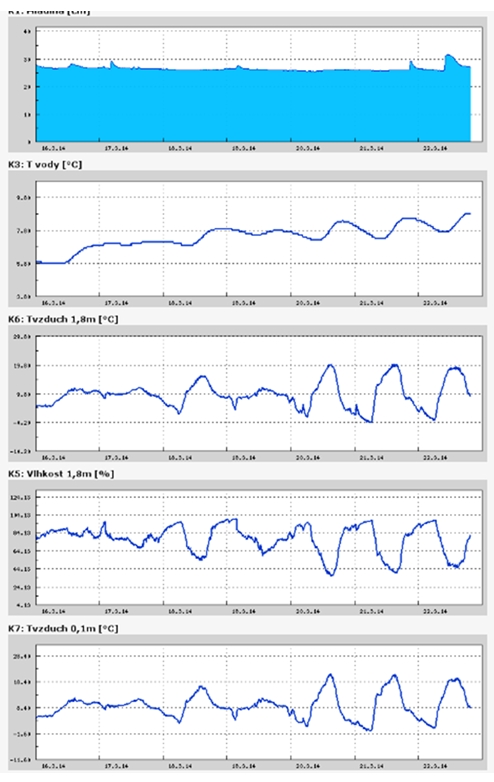
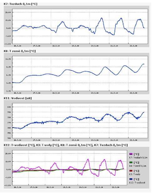
Teplota vzduchu a vody, vlhkost ,
 https://stanice.fiedler-magr.cz
Archiv
53_201352_2013
51_2013
50_2013
49_2013
48_2013
47_2013
46_2013
45_2013
44_2013
43_2013
42_2013
41_2013
40_2013
39_2013
38_2013
37_2013
36_2013
35_2013
34_2013
33_2013
32_2013
31_2013
30_2013
29_2013
28_2013
27_2013
26_2013
25_2013
24_2013
23_2013
22_2013
21_2013
20_2013
19_2013
18_2013
17_2013
16_2013
15_2013
14_2013
13_2013
12_2013
11_2013
10_2013
09_2013
08_2013
07_2013
06_2013
05_2013
04_2013
03_2013
02_2013
01_2013

 | Zemědělská 1/1665 613 00 Brno Budova D | Tel.: +420 545 133 350 Fax.: +420 545 212 044 |  |
 |