

Účelem vzdělání není zaplnit mysl, ale otevřít ji. Čím více poznatků si osvojíme, tím víc si uvědomíme, co ještě neznáme.
Konference
Konference v roce 2015
Konference v roce 2014
Konference v roce 2013
Konference v roce 2012
Konference v roce 2011


Polní laboratoř
 Cirus fibratus, Cirostratus, Cumulus humulus, 20. 7 . 2014, 10:00 UTC, W
 Cumulus humilis, Cirus fibratus 20. 7. 2014, 10:55 UTC, W
 Stanice Bořitov – Boskovická brázda 20. 7. 2014 10:45 UTC
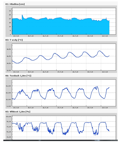
Meteorologická charakteristika za 29. týden 2014 na stanici Bořitov – Boskovická brázda

Meteorologická charakteristika za 29. týden 2014 na stanici Bořitov – letiště

NASA Satellite Catches Birth of Tropical Storm Wali Near Hawaii
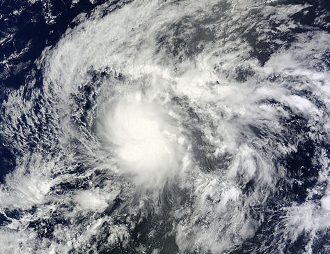 The first tropical cyclone of the season has formed in the Central Pacific Ocean as NASA's Terra satellite passed overhead. Tropical Storm Wali formed southeast of the Big Island of Hawaii, and now that it's nearing, a Flash Flood Watch has been posted for all of the islands.
NASA's Terra satellite passed over Wali on July 17 at 19:55 UTC (3:55 p.m. EDT) just as it was being classified as Tropical Depression 1C. NOAA's Central Pacific Hurricane Center (CPHC) issued an advisory at 5 p.m. EDT (11 a.m. HST) announcing the birth of the depression near 12.7 north and 140.7 west with maximum sustained winds near 35 mph (55 kph). When NASA's Terra satellite passed overhead, the Moderate Resolution Imaging Spectrometer (MODIS) took a visible picture of the storm and it appeared somewhat elongated.
One hour after its birth as a tropical depression (2200 UTC/6 p.m. EDT/12 p.m. HDT) Tropical Depression 1C became Tropical Storm Wali as maximum sustained winds ramped up to 45 mph (75 kph).
On July 18 at 0900 UTC (5 a.m. EDT/July 17 at 11 p.m. HST/) Tropical Storm Wali's maximum sustained winds remained near 45 mph (75 kph), and the CPHC noted that slight strengthening is possible for the next day before a weakening trend begins. Wali was located near latitude 14.1 north, longitude 141.6 west, about 970 miles (1,565 km) east-southeast of Hilo, Hawaii. Wali was moving toward the northwest near 12 mph (19 kph) and CPHC expects Wali to continue in that direction until it makes a slight turn toward the west on Saturday. The estimated minimum central pressure is 1003 millibars.
The National Weather Service (NWS) in Honolulu issued a Flash Flood Watch for the Hawaiian Islands from Saturday night (July 19) through Monday (July 21). The NWS noted "deep tropical moisture combined with an upper level trough will bring the threat of heavy rain and thunderstorms from Saturday night through Monday. Enhanced showers will reach the windward Big Island and Maui Saturday night, and the rest of the state Sunday."
The CPHC expects Wali to maintain tropical storm status until late Saturday, July 19, when it is expected to weaken to a depression. Increasing vertical wind shear, cooler sea surface temperatures and drier air that is expected to move into Wali are three factors that will contribute to weakening the storm as it approaches the Big Island. However, heavy rainfall is expected to affect the Hawaiian islands later this weekend as the current forecast track for Wali takes it on a path toward the Big Island of Hawaii late Sunday, July 20 or early Monday, July 21.
The first tropical cyclone of the season has formed in the Central Pacific Ocean as NASA's Terra satellite passed overhead. Tropical Storm Wali formed southeast of the Big Island of Hawaii, and now that it's nearing, a Flash Flood Watch has been posted for all of the islands.
NASA's Terra satellite passed over Wali on July 17 at 19:55 UTC (3:55 p.m. EDT) just as it was being classified as Tropical Depression 1C. NOAA's Central Pacific Hurricane Center (CPHC) issued an advisory at 5 p.m. EDT (11 a.m. HST) announcing the birth of the depression near 12.7 north and 140.7 west with maximum sustained winds near 35 mph (55 kph). When NASA's Terra satellite passed overhead, the Moderate Resolution Imaging Spectrometer (MODIS) took a visible picture of the storm and it appeared somewhat elongated.
One hour after its birth as a tropical depression (2200 UTC/6 p.m. EDT/12 p.m. HDT) Tropical Depression 1C became Tropical Storm Wali as maximum sustained winds ramped up to 45 mph (75 kph).
On July 18 at 0900 UTC (5 a.m. EDT/July 17 at 11 p.m. HST/) Tropical Storm Wali's maximum sustained winds remained near 45 mph (75 kph), and the CPHC noted that slight strengthening is possible for the next day before a weakening trend begins. Wali was located near latitude 14.1 north, longitude 141.6 west, about 970 miles (1,565 km) east-southeast of Hilo, Hawaii. Wali was moving toward the northwest near 12 mph (19 kph) and CPHC expects Wali to continue in that direction until it makes a slight turn toward the west on Saturday. The estimated minimum central pressure is 1003 millibars.
The National Weather Service (NWS) in Honolulu issued a Flash Flood Watch for the Hawaiian Islands from Saturday night (July 19) through Monday (July 21). The NWS noted "deep tropical moisture combined with an upper level trough will bring the threat of heavy rain and thunderstorms from Saturday night through Monday. Enhanced showers will reach the windward Big Island and Maui Saturday night, and the rest of the state Sunday."
The CPHC expects Wali to maintain tropical storm status until late Saturday, July 19, when it is expected to weaken to a depression. Increasing vertical wind shear, cooler sea surface temperatures and drier air that is expected to move into Wali are three factors that will contribute to weakening the storm as it approaches the Big Island. However, heavy rainfall is expected to affect the Hawaiian islands later this weekend as the current forecast track for Wali takes it on a path toward the Big Island of Hawaii late Sunday, July 20 or early Monday, July 21.
NASA's Aqua Satellite Gets Infrared Hint on Tropical Depression 2
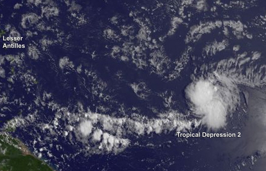 Infrared data gathered on the tropical low pressure area known as System 92L gave forecasters a hint that the low would become the Atlantic Ocean hurricane season's second tropical depression.
NASA's Aqua satellite passed over System 92L on July 21 at 11:53 a.m. EDT and the Atmospheric Infrared Sounder (AIRS) instrument gathered infrared data on the developing low pressure area. The infrared data shows temperature, and AIRS data showed some areas of very cold cloud top temperatures, exceeding the threshold of -63F/-52C that indicates cloud tops near the top of the troposphere. Those cloud top temperatures are also indicative of strong uplift (of air) and powerful thunderstorms. Soon after the AIRS data was taken the low that became Tropical Depression 2.
At 11 a.m. EDT (1500 UTC) on July 222, the center of Tropical Depression Two (TD2) was located near latitude 12.6 north and longitude 48.0 west, about 910 miles (1,465 km) east of the Lesser Antilles. Tropical Depression Two had maximum sustained winds near 35 mph (55 kph) but the National Hurricane Center (NHC) expects little change in strength over the next 24 hours. The depression is moving toward the west near 17 mph (28 kph) and that general motion is expected to continue for the next couple of days. The estimated minimum central pressure is 1012 millibars.
The NHC noted that Tropical Depression 2 will be moving through an environment of dry air and increasing vertical wind shear that will not favor strengthening. In fact, NHC forecasters expect that TD2 may weaken to a remnant low by Wednesday, July 23, and degenerate into a trough (elongated area) of low pressure on Thursday.
Infrared data gathered on the tropical low pressure area known as System 92L gave forecasters a hint that the low would become the Atlantic Ocean hurricane season's second tropical depression.
NASA's Aqua satellite passed over System 92L on July 21 at 11:53 a.m. EDT and the Atmospheric Infrared Sounder (AIRS) instrument gathered infrared data on the developing low pressure area. The infrared data shows temperature, and AIRS data showed some areas of very cold cloud top temperatures, exceeding the threshold of -63F/-52C that indicates cloud tops near the top of the troposphere. Those cloud top temperatures are also indicative of strong uplift (of air) and powerful thunderstorms. Soon after the AIRS data was taken the low that became Tropical Depression 2.
At 11 a.m. EDT (1500 UTC) on July 222, the center of Tropical Depression Two (TD2) was located near latitude 12.6 north and longitude 48.0 west, about 910 miles (1,465 km) east of the Lesser Antilles. Tropical Depression Two had maximum sustained winds near 35 mph (55 kph) but the National Hurricane Center (NHC) expects little change in strength over the next 24 hours. The depression is moving toward the west near 17 mph (28 kph) and that general motion is expected to continue for the next couple of days. The estimated minimum central pressure is 1012 millibars.
The NHC noted that Tropical Depression 2 will be moving through an environment of dry air and increasing vertical wind shear that will not favor strengthening. In fact, NHC forecasters expect that TD2 may weaken to a remnant low by Wednesday, July 23, and degenerate into a trough (elongated area) of low pressure on Thursday.
Tropical Storm Genevieve Forms in Eastern Pacific
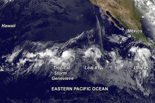 The seventh tropical depression of the Eastern Pacific Ocean formed and quickly ramped up to a tropical storm named "Genevieve." NOAA's GOES-West satellite captured an infrared image of the newborn storm being trailed by two other areas of developing low pressure to its east.
The National Hurricane Center (NHC) noted that Tropical Storm Genevieve was born on July 25 at 5 a.m. EDT. At that time, Genevieve had maximum sustained winds near 40 mph (65 kph). It was located near 12.2 north latitude and 134.4 west longitude, about 1,490 miles (2,400 km) east-southeast of South Point, Hawaii.
NOAA's GOES-West satellite captured an infrared picture of Genevieve on July 25 at 8 a.m. EDT. The bulk of the storm's clouds appeared to be pushed east of the center, indicating that westerly wind shear was affecting the storm. The GOES image also showed that Genevieve was being "followed" by two other developing areas of low pressure to the east of the storm.
By 11 a.m. EDT (1500 UTC), Genevieve's winds increased to 45 mph (75 kph). The center of Tropical Storm Genevieve was located near latitude 12.3 north and longitude 135.5 west, moving 70 miles closer to South Point, Hawaii but still over 1,400 miles away. Genevieve was moving toward the west near 10 mph (17 kph) and NHC expects her to continue moving in a westerly direction over the next day or two. The estimated minimum central pressure is 1004 millibars.
NHC Forecaster Avila indicated that Genevieve's low-level center continues to be located to the west of the convection. The NHC doesn't expect Genevieve to strengthen because upper-level westerly winds are expected to move closer to the tropical storm and increase wind shear. Increased wind shear weakens tropical cyclones.
Trailing behind Genevieve to the storm's east are two other developing low pressure areas. Area #1 is located a little more than a thousand miles southwest of the southern tip of the Baja California, Mexico peninsula and is producing disorganized shower activity. The National Hurricane Center noted that there is some potential for development during the next day or two before the environment becomes unfavorable. Right now the low has a medium chance for development over the next two days as it moves to the west or west-northwest
East-southeast of Area #1 is the second developing low pressure area and south of Mexico's southern coast. That low, however is large and disorganized. The showers and thunderstorms in that area are associated with a tropical wave. Area #2 has a low chance for development over the next two days, according to NHC, but its chances are expected to improve five days out.
The seventh tropical depression of the Eastern Pacific Ocean formed and quickly ramped up to a tropical storm named "Genevieve." NOAA's GOES-West satellite captured an infrared image of the newborn storm being trailed by two other areas of developing low pressure to its east.
The National Hurricane Center (NHC) noted that Tropical Storm Genevieve was born on July 25 at 5 a.m. EDT. At that time, Genevieve had maximum sustained winds near 40 mph (65 kph). It was located near 12.2 north latitude and 134.4 west longitude, about 1,490 miles (2,400 km) east-southeast of South Point, Hawaii.
NOAA's GOES-West satellite captured an infrared picture of Genevieve on July 25 at 8 a.m. EDT. The bulk of the storm's clouds appeared to be pushed east of the center, indicating that westerly wind shear was affecting the storm. The GOES image also showed that Genevieve was being "followed" by two other developing areas of low pressure to the east of the storm.
By 11 a.m. EDT (1500 UTC), Genevieve's winds increased to 45 mph (75 kph). The center of Tropical Storm Genevieve was located near latitude 12.3 north and longitude 135.5 west, moving 70 miles closer to South Point, Hawaii but still over 1,400 miles away. Genevieve was moving toward the west near 10 mph (17 kph) and NHC expects her to continue moving in a westerly direction over the next day or two. The estimated minimum central pressure is 1004 millibars.
NHC Forecaster Avila indicated that Genevieve's low-level center continues to be located to the west of the convection. The NHC doesn't expect Genevieve to strengthen because upper-level westerly winds are expected to move closer to the tropical storm and increase wind shear. Increased wind shear weakens tropical cyclones.
Trailing behind Genevieve to the storm's east are two other developing low pressure areas. Area #1 is located a little more than a thousand miles southwest of the southern tip of the Baja California, Mexico peninsula and is producing disorganized shower activity. The National Hurricane Center noted that there is some potential for development during the next day or two before the environment becomes unfavorable. Right now the low has a medium chance for development over the next two days as it moves to the west or west-northwest
East-southeast of Area #1 is the second developing low pressure area and south of Mexico's southern coast. That low, however is large and disorganized. The showers and thunderstorms in that area are associated with a tropical wave. Area #2 has a low chance for development over the next two days, according to NHC, but its chances are expected to improve five days out.
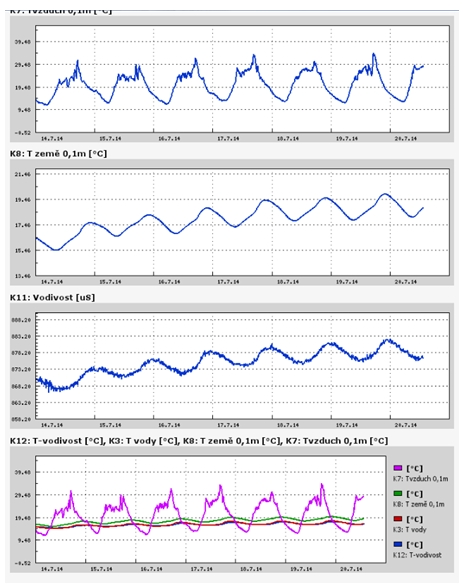
Lysický potok, hydrologicko meteorologická charakteristika za 29. týden 2014 -Teplota vzduchu a vody, vlhkost ,
Archiv
28_201427_2014
26_2014
26_2014
25_2014
24_2014
23_2014
22_2014
21_2014
20_2014
20_2014
20_2014
19_2014
18_2014
17_2014
16_2014
15_2014
14_2014
54_2013
53_2013
52_2013
51_2013
50_2013
49_2013
48_2013
47_2013
46_2013
45_2013
44_2013
43_2013
42_2013
41_2013
40_2013
39_2013
38_2013
37_2013
36_2013
35_2013
34_2013
33_2013
32_2013
31_2013
30_2013
29_2013
28_2013
27_2013
26_2013
25_2013
24_2013
23_2013
22_2013
21_2013
20_2013
19_2013
18_2013
17_2013
16_2013
15_2013
14_2013
13_2013
12_2013
11_2013
10_2013
09_2013
08_2013
07_2013
06_2013
05_2013
04_2013
03_2013
02_2013
01_2013

 | Zemědělská 1/1665 613 00 Brno Budova D | Tel.: +420 545 133 350 Fax.: +420 545 212 044 |  |
 |