

Vědět a znát, to mnohý by chtěl, ale učit se nechce.
Walther Von Der Vegelweide
Konference
Konference v roce 2015
Konference v roce 2014
Konference v roce 2013
Konference v roce 2012
Konference v roce 2011


Polní laboratoř
NASA Catches Short-Lived Tropical Storm Ivanoe
 Tropical Storm Ivanoe formed in the Southern Indian Ocean on April 5 and didn't last more than a day, but NASA's Tropical Rainfall Measuring Mission captured rainfall data on the short-lived storm. Within 24 hours the tropical storm transitioned into an extra-tropical storm.
On April 5 at 1500 UTC/11 a.m. EDT, Ivanoe's maximum sustained winds were near 40 knots/46.3 mph/74.0 kph. The Joint Typhoon Warning Center placed the center of Ivanoe near 21.3 south and 83.3 east, about 960 nautical miles southwest of Cocos Island. Ivanoe tracked south-southeastward at 18 knots/20.7 mph/33.3 kph.
Animated multispectral satellite imagery on April 5 showed that the majority of Ivanoe's strongest thunderstorms were being pushed or sheared to the southeast from strong northwesterly wind shear.
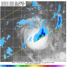
The U.S. Naval Research Laboratory combined rainfall data from NASA's Tropical Rainfall Measuring Mission satellite known as TRMM with infrared cloud data from the METEO-7 satellite. METEO-7 is managed by EUMETSAT, the European Organization for the Exploitation of Meteorological Satellites.
The combination satellite image from April 5 at 2031 UTC/4:31 p.m. EDT showed rain near 1 inch/25 mm per hour east and south of the center. The rainfall data was overlaid on infrared data from the METEO-7 satellite depicting the clouds associated with the tropical storm.
The Joint Typhoon Warning Center issued its fifth and final warning on Ivanoe on April 6 at 1500 UTC. At that time, Ivanoe was centered near 30.3S south and 88.7 east, about 1,664 nautical miles south-southeast of Diego Garcia. Ivanoe was speeding to the south-southeast at 28 knots/32.2 mph/51.8 kph and had maximum sustained winds near 40 knots/46.0 mph/74.0 kph.
By the end of the day on April 6, Ivanoe became extra-tropical.
Tropical Storm Ivanoe formed in the Southern Indian Ocean on April 5 and didn't last more than a day, but NASA's Tropical Rainfall Measuring Mission captured rainfall data on the short-lived storm. Within 24 hours the tropical storm transitioned into an extra-tropical storm.
On April 5 at 1500 UTC/11 a.m. EDT, Ivanoe's maximum sustained winds were near 40 knots/46.3 mph/74.0 kph. The Joint Typhoon Warning Center placed the center of Ivanoe near 21.3 south and 83.3 east, about 960 nautical miles southwest of Cocos Island. Ivanoe tracked south-southeastward at 18 knots/20.7 mph/33.3 kph.
Animated multispectral satellite imagery on April 5 showed that the majority of Ivanoe's strongest thunderstorms were being pushed or sheared to the southeast from strong northwesterly wind shear.
The U.S. Naval Research Laboratory combined rainfall data from NASA's Tropical Rainfall Measuring Mission satellite known as TRMM with infrared cloud data from the METEO-7 satellite. METEO-7 is managed by EUMETSAT, the European Organization for the Exploitation of Meteorological Satellites.
The combination satellite image from April 5 at 2031 UTC/4:31 p.m. EDT showed rain near 1 inch/25 mm per hour east and south of the center. The rainfall data was overlaid on infrared data from the METEO-7 satellite depicting the clouds associated with the tropical storm.
The Joint Typhoon Warning Center issued its fifth and final warning on Ivanoe on April 6 at 1500 UTC. At that time, Ivanoe was centered near 30.3S south and 88.7 east, about 1,664 nautical miles south-southeast of Diego Garcia. Ivanoe was speeding to the south-southeast at 28 knots/32.2 mph/51.8 kph and had maximum sustained winds near 40 knots/46.0 mph/74.0 kph.
By the end of the day on April 6, Ivanoe became extra-tropical.
NASA Catches Tropical Cyclone Ita Near Papua New Guinea
 The twenty-third tropical cyclone of the Southern Pacific tropical cyclone season has developed near the Solomon Islands and strengthened into Tropical Storm Ita on April 5. NASA satellite imagery showed the center of circulation just southwest of Sudest Island. Sudest is a volcanic island within Milne Bay Province of Papua New Guinea.
On April 5 at 2100 UTC/5:00 p.m. EDT, Ita formed in the Coral Sea, about 599 nautical miles east-northeast of Cairns, Australia, and was moving to the west-southwestward at 5 knots/5.7 mph/9.2 kph. At that time, maximum sustained winds were near 45 knots/51.7 mph/83 kph.
Satellite data on April 5 showed that strong convection (and developing thunderstorms) were along both the southern and eastern quadrants of the newborn storm.
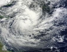
On April 6, when NASA's Terra satellite passed over Ita the Moderate Resolution Imaging Spectroradiometer (MODIS) instrument captured a visible image of the storm. The image was created by NASA's MODIS Rapid Response Team at the NASA Goddard Space Flight Center in Greenbelt, Md. The MODIS image showed strong thunderstorms surrounding the tightly-wrapped center of circulation, just southeast of Sudest Island. Bands of thunderstorms were wrapping into the center from the north and east, and from the southwest.
At 1200 UTC/8 a.m. EDT/10 p.m. local time (Brisbane/Australia) on April 7, Tropical Cyclone Ita was located over the northern Coral Sea near latitude 12.1 south and longitude 153.4 east, about 532 nautical miles/612.2 miles/985.3 km northeast of Cairns, Queensland. Maximum sustained winds were near 45 knots/51.7 mph/83.3 kph.
The Joint Typhoon Warning Center (JTWC) expects Ita to move to the west then southwest over the next several days. JTWC forecasters expect Ita to make landfall in the northeastern Cape York Peninsula of Queensland, Australia around April 11. Currently there are no watches posted yet, but the Australian Bureau of Meteorology noted that Ita could begin affecting the Queensland coast on Wednesday, April 9.
The twenty-third tropical cyclone of the Southern Pacific tropical cyclone season has developed near the Solomon Islands and strengthened into Tropical Storm Ita on April 5. NASA satellite imagery showed the center of circulation just southwest of Sudest Island. Sudest is a volcanic island within Milne Bay Province of Papua New Guinea.
On April 5 at 2100 UTC/5:00 p.m. EDT, Ita formed in the Coral Sea, about 599 nautical miles east-northeast of Cairns, Australia, and was moving to the west-southwestward at 5 knots/5.7 mph/9.2 kph. At that time, maximum sustained winds were near 45 knots/51.7 mph/83 kph.
Satellite data on April 5 showed that strong convection (and developing thunderstorms) were along both the southern and eastern quadrants of the newborn storm.
On April 6, when NASA's Terra satellite passed over Ita the Moderate Resolution Imaging Spectroradiometer (MODIS) instrument captured a visible image of the storm. The image was created by NASA's MODIS Rapid Response Team at the NASA Goddard Space Flight Center in Greenbelt, Md. The MODIS image showed strong thunderstorms surrounding the tightly-wrapped center of circulation, just southeast of Sudest Island. Bands of thunderstorms were wrapping into the center from the north and east, and from the southwest.
At 1200 UTC/8 a.m. EDT/10 p.m. local time (Brisbane/Australia) on April 7, Tropical Cyclone Ita was located over the northern Coral Sea near latitude 12.1 south and longitude 153.4 east, about 532 nautical miles/612.2 miles/985.3 km northeast of Cairns, Queensland. Maximum sustained winds were near 45 knots/51.7 mph/83.3 kph.
The Joint Typhoon Warning Center (JTWC) expects Ita to move to the west then southwest over the next several days. JTWC forecasters expect Ita to make landfall in the northeastern Cape York Peninsula of Queensland, Australia around April 11. Currently there are no watches posted yet, but the Australian Bureau of Meteorology noted that Ita could begin affecting the Queensland coast on Wednesday, April 9.
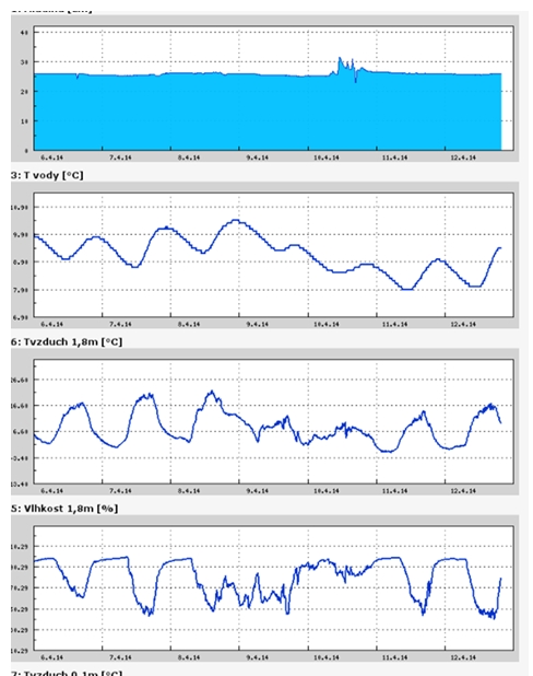
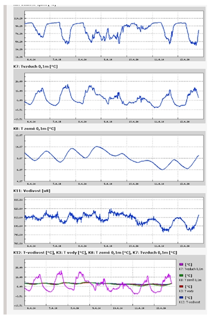
Teplota vzduchu a vody, vlhkost ,
 https://stanice.fiedler-magr.cz
Archiv
15_201414_2014
54_2013
53_2013
52_2013
51_2013
50_2013
49_2013
48_2013
47_2013
46_2013
45_2013
44_2013
43_2013
42_2013
41_2013
40_2013
39_2013
38_2013
37_2013
36_2013
35_2013
34_2013
33_2013
32_2013
31_2013
30_2013
29_2013
28_2013
27_2013
26_2013
25_2013
24_2013
23_2013
22_2013
21_2013
20_2013
19_2013
18_2013
17_2013
16_2013
15_2013
14_2013
13_2013
12_2013
11_2013
10_2013
09_2013
08_2013
07_2013
06_2013
05_2013
04_2013
03_2013
02_2013
01_2013

 | Zemědělská 1/1665 613 00 Brno Budova D | Tel.: +420 545 133 350 Fax.: +420 545 212 044 |  |
 |