

Důkazem vysokého vzdělání je schopnost mluvit o největších věcech nejjednodušším způsobem.
David Hume
Konference
Konference v roce 2015
Konference v roce 2014
Konference v roce 2013
Konference v roce 2012
Konference v roce 2011


Polní laboratoř
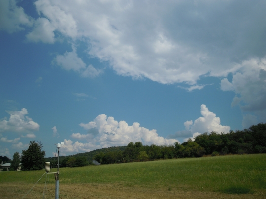 Cumulus humulus, Cumulus mediocris, Cumulus congestus 27. 7 . 2014, 10:30 UTC, N
 Cumulus humilis, Cumulus congestus, Cumuls fractus 27. 7. 2014, 10:55 UTC, NEN

 Stanice Bořitov – Boskovická brázda 27. 7. 2014 10:45 UTC
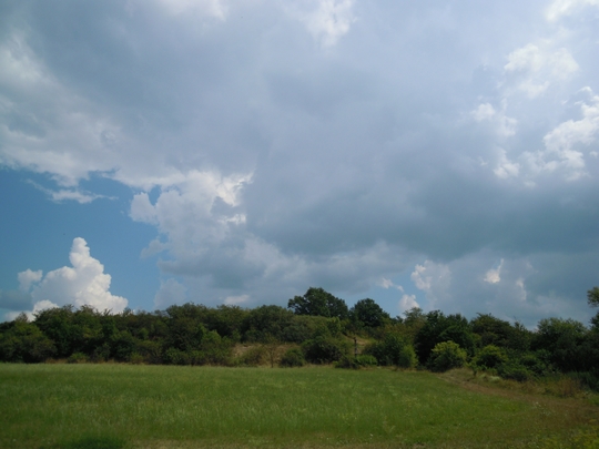
 Cumulus mediocris, Cumulus humilis, Acumulus lenticularis, Cumulus fractus, 27. 7. 2014 14:45 UTC
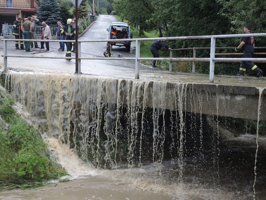 Prudké lijáky se ve čtvrtek odpoledne přehnaly přes Zlínsko. V samotném krajském městě způsobily kolaps dopravy, když voda zaplavila několik páteřních silnic a podjezd. Nejvážnější situace však byla v Bohuslavicích u Zlína a v Šarovech, kde voda z potoků ohrožovala obyvatele domů i automobily na silnicích.
Lokální povodně se objevily nejen ve Zlíně a obou jmenovaných vesnicích, ale i v Oldřichovicích, Karlovicích a Napajedlích, později v Bratřejově, Uble a Lutonině. Ve Vizovicích město raději vyhlásilo všeobecnou výstrahu. V samotném Zlíně zasedla v sedmnáct hodin povodňová komise. „Ve Zlíně jsme první hlášení o zaplavení objektu přijali v 15:41. Další oznámení přicházela v minutových intervalech z různých částí krajského města. Jednalo se o zaplavení komunikací, sklepů bytových domů, ale i skladů, prodejen, provozních budov a restaurací,“ přiblížil mluvčí krajských hasičů Libor Netopil. Voda se v krajském městě valila také přes schody u Gahurova prospektu do nově opraveného podchodu, ale i do obchodního centra Zlaté jablko i na autobusové nádraží a do přilehlých parků. Místy dosahovala až půlmetrové výše.
Ve Zlíně totálně ochromila dopravu směrem na největší zlínské sídliště Jižní Svahy a na dalších páteřních komunikacích. Dostala se do sklepů mnoha objektů. Obdobně řádila i v blízkých vesnicích. „Pily jsme doma zrovna kafe, když začalo pršet. Pak jsme jen viděly, jak se z potoka od Lhoty valí velká voda. Během pěti minut jsme jí doma a na dvoře měly až po stehna. Je to neštěstí,“ přiblížila Bohumila Jahodová ze Šarov u Zlína.
Prudké lijáky se ve čtvrtek odpoledne přehnaly přes Zlínsko. V samotném krajském městě způsobily kolaps dopravy, když voda zaplavila několik páteřních silnic a podjezd. Nejvážnější situace však byla v Bohuslavicích u Zlína a v Šarovech, kde voda z potoků ohrožovala obyvatele domů i automobily na silnicích.
Lokální povodně se objevily nejen ve Zlíně a obou jmenovaných vesnicích, ale i v Oldřichovicích, Karlovicích a Napajedlích, později v Bratřejově, Uble a Lutonině. Ve Vizovicích město raději vyhlásilo všeobecnou výstrahu. V samotném Zlíně zasedla v sedmnáct hodin povodňová komise. „Ve Zlíně jsme první hlášení o zaplavení objektu přijali v 15:41. Další oznámení přicházela v minutových intervalech z různých částí krajského města. Jednalo se o zaplavení komunikací, sklepů bytových domů, ale i skladů, prodejen, provozních budov a restaurací,“ přiblížil mluvčí krajských hasičů Libor Netopil. Voda se v krajském městě valila také přes schody u Gahurova prospektu do nově opraveného podchodu, ale i do obchodního centra Zlaté jablko i na autobusové nádraží a do přilehlých parků. Místy dosahovala až půlmetrové výše.
Ve Zlíně totálně ochromila dopravu směrem na největší zlínské sídliště Jižní Svahy a na dalších páteřních komunikacích. Dostala se do sklepů mnoha objektů. Obdobně řádila i v blízkých vesnicích. „Pily jsme doma zrovna kafe, když začalo pršet. Pak jsme jen viděly, jak se z potoka od Lhoty valí velká voda. Během pěti minut jsme jí doma a na dvoře měly až po stehna. Je to neštěstí,“ přiblížila Bohumila Jahodová ze Šarov u Zlína.
New Tropical Depression Forms in Northwestern Pacific Ocean
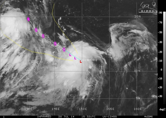 Tropical Depression 11W has formed in the Northwestern Pacific and is expected to track through the Marianas Islands.
Infrared satellite imagery created at the University of Wisconsin-Madison on July 28 at 15:32 UTC (11:31 a.m. EDT) shows the storm somewhat elongated from northeast to southwest. The Joint Typhoon Warning Center (JTWC) noted just 30 minutes before the satellite image that Tropical Depression 11W had maximum sustained winds near 25 knots (28.7 mph/46.3 kph). It was located about 304 nautical miles (349.8 miles/563 km) east-southeast of Andersen Air Force Base, Guam. That puts its center near 12.0 north latitude and 149.8 east longitude. It was moving to the west-northwest at 11 knots (12.6 mph/20.3 kph).
11W is expected to move west-northwest through the Marianas Islands, over the next couple of days. The forecasters at the JTWC expect 11W to pass to the northeast of Guam on July 30.
Tropical Depression 11W has formed in the Northwestern Pacific and is expected to track through the Marianas Islands.
Infrared satellite imagery created at the University of Wisconsin-Madison on July 28 at 15:32 UTC (11:31 a.m. EDT) shows the storm somewhat elongated from northeast to southwest. The Joint Typhoon Warning Center (JTWC) noted just 30 minutes before the satellite image that Tropical Depression 11W had maximum sustained winds near 25 knots (28.7 mph/46.3 kph). It was located about 304 nautical miles (349.8 miles/563 km) east-southeast of Andersen Air Force Base, Guam. That puts its center near 12.0 north latitude and 149.8 east longitude. It was moving to the west-northwest at 11 knots (12.6 mph/20.3 kph).
11W is expected to move west-northwest through the Marianas Islands, over the next couple of days. The forecasters at the JTWC expect 11W to pass to the northeast of Guam on July 30.
NASA Sees Tropical Storm Hernan Near Mexico's Baja California
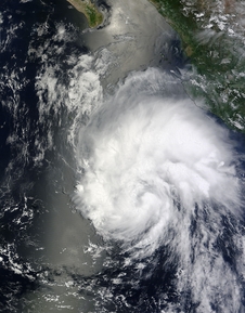 Tropical Storm Hernan developed over this past weekend and reached hurricane strength before vertical wind shear kicked in and kicked the storm down. NASA's Terra satellite passed over Hernan when it was developing as a tropical depression near Baja California, Mexico.
Tropical Storm Hernan was born on Saturday, July 26 at 5 a.m. EDT as Tropical Depression 8-E. By 5 p.m. EDT it strengthened into Tropical Storm Hernan. At 11 a.m. EDT on Sunday, July 27, Hernan's maximum sustained winds were already up to 70 mph, just four miles per hour shy of hurricane status. As Hernan passed west of Socorro Island at 5 p.m. EDT on July 28 it reached hurricane status when its maximum sustained winds reached 75 mph (120 kph). It remained a hurricane for about 12 hours before dropping back to a tropical storm on July 29 at 5 a.m. EDT when maximum sustained winds were near 70 mph (110 kph).
Hernan moved into an area of persistent westerly wind shear blowing at between 15 to 20 knots (17.2 to 23.0 mph/27.8 to 37.0 kph). That wind shear is deteriorating the cyclone's organization. Infrared satellite data from instruments like the Atmospheric Infrared Sounder (AIRS) aboard NASA's Aqua satellite showed that the cloud top temperatures were warming. Warming cloud tops means that the uplift of air had weakened. Uplift is air that pushes thunderstorms into the top of the troposphere. The higher the thunderstorm cloud top, the colder it is (because the troposphere cools as you go higher). Higher, colder cloud tops in thunderstorms mean stronger thunderstorms.
Visible satellite data today indicated "a rather shapeless cloud pattern," according to the National Hurricane Center. That means the circulation is less organized.
At 11 a.m. EDT (1500 UTC) on July 28, Tropical Storm Hernan's maximum sustained winds were down to 65 mph (100 kph). It was centered near 20.5 north latitude and 115.9 west longitude, about 420 miles west-southwest (675 km) of the southern tip of Baja California. Hernan is moving toward the northwest near 16 mph (26 kph) and is forecast to continue through Tuesday night, July 29, followed by a turn to the west.
Forecaster Roberts at the National Hurricane Center noted today, July 28 that in addition to being battered by wind shear, "an increasingly stable air mass and decreasing sea surface temperatures should ultimately weaken Hernan into a shallow post-tropical cyclone in 48 hours."
Tropical Storm Hernan developed over this past weekend and reached hurricane strength before vertical wind shear kicked in and kicked the storm down. NASA's Terra satellite passed over Hernan when it was developing as a tropical depression near Baja California, Mexico.
Tropical Storm Hernan was born on Saturday, July 26 at 5 a.m. EDT as Tropical Depression 8-E. By 5 p.m. EDT it strengthened into Tropical Storm Hernan. At 11 a.m. EDT on Sunday, July 27, Hernan's maximum sustained winds were already up to 70 mph, just four miles per hour shy of hurricane status. As Hernan passed west of Socorro Island at 5 p.m. EDT on July 28 it reached hurricane status when its maximum sustained winds reached 75 mph (120 kph). It remained a hurricane for about 12 hours before dropping back to a tropical storm on July 29 at 5 a.m. EDT when maximum sustained winds were near 70 mph (110 kph).
Hernan moved into an area of persistent westerly wind shear blowing at between 15 to 20 knots (17.2 to 23.0 mph/27.8 to 37.0 kph). That wind shear is deteriorating the cyclone's organization. Infrared satellite data from instruments like the Atmospheric Infrared Sounder (AIRS) aboard NASA's Aqua satellite showed that the cloud top temperatures were warming. Warming cloud tops means that the uplift of air had weakened. Uplift is air that pushes thunderstorms into the top of the troposphere. The higher the thunderstorm cloud top, the colder it is (because the troposphere cools as you go higher). Higher, colder cloud tops in thunderstorms mean stronger thunderstorms.
Visible satellite data today indicated "a rather shapeless cloud pattern," according to the National Hurricane Center. That means the circulation is less organized.
At 11 a.m. EDT (1500 UTC) on July 28, Tropical Storm Hernan's maximum sustained winds were down to 65 mph (100 kph). It was centered near 20.5 north latitude and 115.9 west longitude, about 420 miles west-southwest (675 km) of the southern tip of Baja California. Hernan is moving toward the northwest near 16 mph (26 kph) and is forecast to continue through Tuesday night, July 29, followed by a turn to the west.
Forecaster Roberts at the National Hurricane Center noted today, July 28 that in addition to being battered by wind shear, "an increasingly stable air mass and decreasing sea surface temperatures should ultimately weaken Hernan into a shallow post-tropical cyclone in 48 hours."
Reporters Invited to NASA Hurricane Airborne Mission Media Day at Wallops
 A look at NASA's Global Hawk unmanned aircraft from one of the wings. The Global Hawk is sitting at the aircraft hangar of NASA's Wallops Flight Facility in Wallops Island, Va on Sept. 7, 2012.
Image Credit:
NASA Wallops/Brea Reeves
Media are invited to learn about NASA's Hurricane and Severe Storm Sentinel (HS3) airborne mission from scientists and pilots and see the remotely-piloted aircraft used in the study from 10 a.m. to 1 p.m. EDT, Thursday, Sept. 11, at NASA’s Wallops Flight Facility in Virginia.
This is the final year of the HS3 mission, which uses NASA instrumented Global Hawk aircraft to investigate the processes that underlie hurricane formation and intensity change in the Atlantic Ocean basin. Two aircraft will be stationed at Wallops this year, one carrying an instrument suite geared toward measurement of the outer environment of storms and the other with instruments designed to study the inner core of tropical cyclones. The aircraft are capable of flight altitudes of up to 55,000 feet and flight durations of as long as 30 hours.
During the media event, reporters will meet HS3 scientists and pilots and tour the unmanned Global Hawks and the aircraft control center. Reporters also will learn about NASA's climate research program and the new technology the agency is using to better understand hurricanes.
A look at NASA's Global Hawk unmanned aircraft from one of the wings. The Global Hawk is sitting at the aircraft hangar of NASA's Wallops Flight Facility in Wallops Island, Va on Sept. 7, 2012.
Image Credit:
NASA Wallops/Brea Reeves
Media are invited to learn about NASA's Hurricane and Severe Storm Sentinel (HS3) airborne mission from scientists and pilots and see the remotely-piloted aircraft used in the study from 10 a.m. to 1 p.m. EDT, Thursday, Sept. 11, at NASA’s Wallops Flight Facility in Virginia.
This is the final year of the HS3 mission, which uses NASA instrumented Global Hawk aircraft to investigate the processes that underlie hurricane formation and intensity change in the Atlantic Ocean basin. Two aircraft will be stationed at Wallops this year, one carrying an instrument suite geared toward measurement of the outer environment of storms and the other with instruments designed to study the inner core of tropical cyclones. The aircraft are capable of flight altitudes of up to 55,000 feet and flight durations of as long as 30 hours.
During the media event, reporters will meet HS3 scientists and pilots and tour the unmanned Global Hawks and the aircraft control center. Reporters also will learn about NASA's climate research program and the new technology the agency is using to better understand hurricanes.

Archiv
29_201428_2014
27_2014
26_2014
26_2014
25_2014
24_2014
23_2014
22_2014
21_2014
20_2014
20_2014
20_2014
19_2014
18_2014
17_2014
16_2014
15_2014
14_2014
54_2013
53_2013
52_2013
51_2013
50_2013
49_2013
48_2013
47_2013
46_2013
45_2013
44_2013
43_2013
42_2013
41_2013
40_2013
39_2013
38_2013
37_2013
36_2013
35_2013
34_2013
33_2013
32_2013
31_2013
30_2013
29_2013
28_2013
27_2013
26_2013
25_2013
24_2013
23_2013
22_2013
21_2013
20_2013
19_2013
18_2013
17_2013
16_2013
15_2013
14_2013
13_2013
12_2013
11_2013
10_2013
09_2013
08_2013
07_2013
06_2013
05_2013
04_2013
03_2013
02_2013
01_2013

 | Zemědělská 1/1665 613 00 Brno Budova D | Tel.: +420 545 133 350 Fax.: +420 545 212 044 |  |
 |