

Důkazem vysokého vzdělání je schopnost mluvit o největších věcech nejjednodušším způsobem.
David Hume
Konference
Konference v roce 2015
Konference v roce 2014
Konference v roce 2013
Konference v roce 2012
Konference v roce 2011


Polní laboratoř
Informace z polní laboratoře – Bořitov
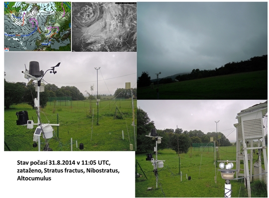
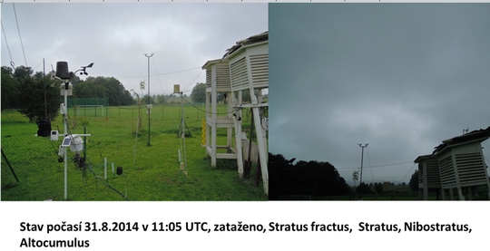
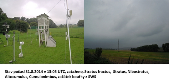
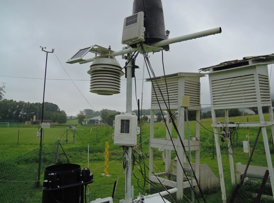 Aktuální stav stanice 31. 8. 2014

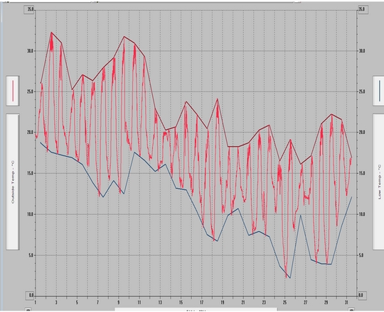
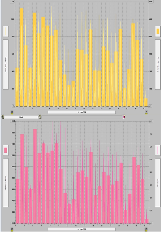
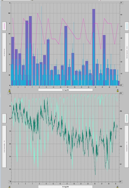
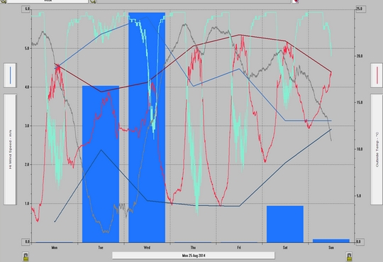 Meteorologické pozorování 1 m nad povrchem trávníku, Bořitov Hlavní stanice
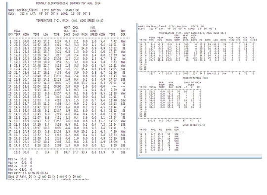 Meteorologické pozorování 2 m nad povrchem trávníku, Bořitov Hlavní stanice


 Meteorologické pozorování, Bořitov letiště
 Meteorologické pozorování, Lysický potok

NASA Satellites Calling Here You Come Again, Tropical Storm Dolly
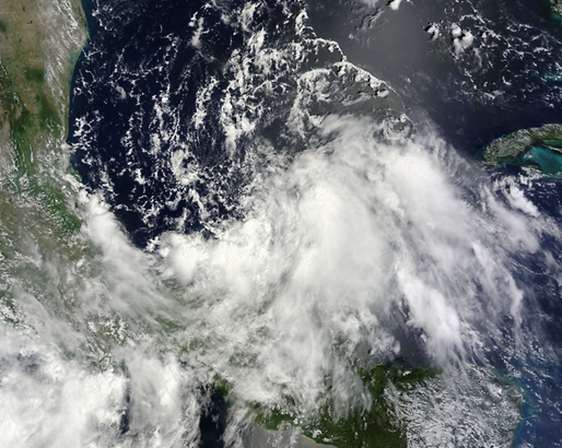 Tropical Storm Dolly visited Mexico six years ago, and NASA satellite data is calling "Here you come again," reminiscent of the famous country singer's hit song, as another storm named Dolly heads for a second landfall in Mexico In July of 2008, Tropical Storm Dolly made landfall on Mexico's Yucatan Peninsula of Mexico before making a second and final landfall in south Texas. Now, six years later, Tropical Storm Dolly returns thanks to the six year list of revolving hurricane names, and once again Dolly is making landfall in eastern Mexico. NASA's Aqua satellite caught Dolly developing over the Yucatan and poised for a second landfall in eastern Mexico today, September 2.
On Sept. 1 at 12:45 p.m. EDT NASA's Terra satellite caught an image of the low pressure area that would become Tropical Storm Dolly, while it was moving over the Yucatan Peninsula. By September 2, the low developed into a tropical storm. The image, taken by the Moderate Resolution Imaging Spectroradiometer or MODIS instrument, showed the low pressure area as somewhat shapeless as it passed over the Yucatan. Once it slid west and entered the warm waters of the Bay of Campeche, it began to develop more. An animation of visible and infrared satellite imagery from NOAA's GOES-East satellite was created by the NASA/NOAA GOES Project at NASA's Goddard Space Flight Center in Greenbelt, Maryland. The animation showed the birth and movement of Dolly from August 31 to September 2. On August 31, Dolly was not yet named and was a low pressure area from the western Caribbean Sea that moved over the Yucatan Peninsula. The animation shows the development of the storm as the low moved across the Bay of Campeche.
The Atmospheric Infrared Sounder or AIRS instrument aboard NASA's Aqua satellite captured infrared data on Tropical Storm Dolly on Sept. 2 at 3:59 a.m. EDT as it neared the east coast of Mexico. The data was made into a false-colored image at NASA's Jet Propulsion Laboratory in Pasadena, California. The AIRS image showed the strongest thunderstorms were on the eastern side of the center of circulation, where cloud tops stretched toward the top of the troposphere. Cloud tops in that area were as cold as -63F/-52C, indicative of high, strong thunderstorms. NASA research shows that thunderstorms with cloud top temperatures that cold have the potential for dropping heavy rainfall. By September 2 at 8 a.m. EDT (1200 UTC) the center of Tropical Storm Dolly was located near latitude 23.0 north and longitude 95.7 west. That puts Dolly's center about 145 miles (230 km) east-southeast of la Pesca, Mexico. Dolly was moving toward the west-northwest near 13 mph (20 kph) and the center of the storm is expected to approach the coast by tonight, September 2, and move inland tomorrow.
Maximum sustained winds have increased to near 50 mph (85 kph) and the National Hurricane Center (NHC) noted that some strengthening is possible until Dolly makes landfall. Tropical-storm-force winds extend outward up to 115 miles (185 km) mostly northeast through southeast of the center.
A tropical storm warning is in force from Tuxpan to Barra el Mezquital. The NHC noted that rainfall totals of 3 to 6, locally up to 10 inches are possible in southern Tamaulipas, northern Veracruz and eastern San Luis Potosi. Those heavy rains will likely cause flash flooding and mudslides in regions of mountainous terrain and that threat will continue as Dolly moves inland.
Tropical Storm Dolly visited Mexico six years ago, and NASA satellite data is calling "Here you come again," reminiscent of the famous country singer's hit song, as another storm named Dolly heads for a second landfall in Mexico In July of 2008, Tropical Storm Dolly made landfall on Mexico's Yucatan Peninsula of Mexico before making a second and final landfall in south Texas. Now, six years later, Tropical Storm Dolly returns thanks to the six year list of revolving hurricane names, and once again Dolly is making landfall in eastern Mexico. NASA's Aqua satellite caught Dolly developing over the Yucatan and poised for a second landfall in eastern Mexico today, September 2.
On Sept. 1 at 12:45 p.m. EDT NASA's Terra satellite caught an image of the low pressure area that would become Tropical Storm Dolly, while it was moving over the Yucatan Peninsula. By September 2, the low developed into a tropical storm. The image, taken by the Moderate Resolution Imaging Spectroradiometer or MODIS instrument, showed the low pressure area as somewhat shapeless as it passed over the Yucatan. Once it slid west and entered the warm waters of the Bay of Campeche, it began to develop more. An animation of visible and infrared satellite imagery from NOAA's GOES-East satellite was created by the NASA/NOAA GOES Project at NASA's Goddard Space Flight Center in Greenbelt, Maryland. The animation showed the birth and movement of Dolly from August 31 to September 2. On August 31, Dolly was not yet named and was a low pressure area from the western Caribbean Sea that moved over the Yucatan Peninsula. The animation shows the development of the storm as the low moved across the Bay of Campeche.
The Atmospheric Infrared Sounder or AIRS instrument aboard NASA's Aqua satellite captured infrared data on Tropical Storm Dolly on Sept. 2 at 3:59 a.m. EDT as it neared the east coast of Mexico. The data was made into a false-colored image at NASA's Jet Propulsion Laboratory in Pasadena, California. The AIRS image showed the strongest thunderstorms were on the eastern side of the center of circulation, where cloud tops stretched toward the top of the troposphere. Cloud tops in that area were as cold as -63F/-52C, indicative of high, strong thunderstorms. NASA research shows that thunderstorms with cloud top temperatures that cold have the potential for dropping heavy rainfall. By September 2 at 8 a.m. EDT (1200 UTC) the center of Tropical Storm Dolly was located near latitude 23.0 north and longitude 95.7 west. That puts Dolly's center about 145 miles (230 km) east-southeast of la Pesca, Mexico. Dolly was moving toward the west-northwest near 13 mph (20 kph) and the center of the storm is expected to approach the coast by tonight, September 2, and move inland tomorrow.
Maximum sustained winds have increased to near 50 mph (85 kph) and the National Hurricane Center (NHC) noted that some strengthening is possible until Dolly makes landfall. Tropical-storm-force winds extend outward up to 115 miles (185 km) mostly northeast through southeast of the center.
A tropical storm warning is in force from Tuxpan to Barra el Mezquital. The NHC noted that rainfall totals of 3 to 6, locally up to 10 inches are possible in southern Tamaulipas, northern Veracruz and eastern San Luis Potosi. Those heavy rains will likely cause flash flooding and mudslides in regions of mountainous terrain and that threat will continue as Dolly moves inland.
Satellite Sees Tropical Storm Norbert Form off Mexico's West Coast
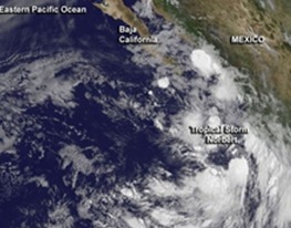 The Eastern Pacific Ocean continues to generate tropical cyclones much faster than the tropical Atlantic as NOAA's GOES-West satellite caught the birth of Tropical Storm Norbert on September 2. The Atlantic is only on its fourth tropical storm with the formation of Dolly today in the Gulf of Mexico.
This GOES-West satellite image of Tropical Storm Norbert was taken at 8 a.m. EDT on September 2 and showed some bands of thunderstorms had formed south of the center of circulation, and around the center.
Image Credit:
NASA/NOAA GOES Project
A visible satellite image of newborn Tropical Storm Norbert was created from NOAA's GOES-West satellite data at the NASA/NOAA GOES Project at NASA's Goddard Space Flight Center in Greenbelt, Maryland. The GOES-West image from 8 a.m. EDT on September 2 showed some bands of thunderstorms had formed around the center and south of the center of circulation. The storm is currently being affected my moderate vertical wind shear from the northeast, which is pushing some of the clouds and showers to the southwest of the center.
Tropical Storm Norbert was born on Tuesday, September 2 at 11 a.m. EDT (1500 UTC), according to satellite imagery and forecasters at the National Hurricane Center (NHC). At that time, Norbert's maximum sustained winds were near 40 mph (65 kph) and some strengthening is forecast during the next 48 hours, according to the NHC. Norbert's center was located near latitude 17.5 north and longitude 106.5 west, about 180 miles (285 km) southwest of Manzanillo, Mexico. It was moving to the north-northeast at 14 mph (22 kph) and is expected to turn to the north before curving to the west-northwest over the next day. Norbert is expected to remain offshore of southwestern Mexico.
Forecaster Blake at the NHC noted that the environment near Norbert seems mostly favorable for strengthening during the next few days with the cyclone forecast over warm waters with moderate (wind) shear.
The Eastern Pacific Ocean continues to generate tropical cyclones much faster than the tropical Atlantic as NOAA's GOES-West satellite caught the birth of Tropical Storm Norbert on September 2. The Atlantic is only on its fourth tropical storm with the formation of Dolly today in the Gulf of Mexico.
This GOES-West satellite image of Tropical Storm Norbert was taken at 8 a.m. EDT on September 2 and showed some bands of thunderstorms had formed south of the center of circulation, and around the center.
Image Credit:
NASA/NOAA GOES Project
A visible satellite image of newborn Tropical Storm Norbert was created from NOAA's GOES-West satellite data at the NASA/NOAA GOES Project at NASA's Goddard Space Flight Center in Greenbelt, Maryland. The GOES-West image from 8 a.m. EDT on September 2 showed some bands of thunderstorms had formed around the center and south of the center of circulation. The storm is currently being affected my moderate vertical wind shear from the northeast, which is pushing some of the clouds and showers to the southwest of the center.
Tropical Storm Norbert was born on Tuesday, September 2 at 11 a.m. EDT (1500 UTC), according to satellite imagery and forecasters at the National Hurricane Center (NHC). At that time, Norbert's maximum sustained winds were near 40 mph (65 kph) and some strengthening is forecast during the next 48 hours, according to the NHC. Norbert's center was located near latitude 17.5 north and longitude 106.5 west, about 180 miles (285 km) southwest of Manzanillo, Mexico. It was moving to the north-northeast at 14 mph (22 kph) and is expected to turn to the north before curving to the west-northwest over the next day. Norbert is expected to remain offshore of southwestern Mexico.
Forecaster Blake at the NHC noted that the environment near Norbert seems mostly favorable for strengthening during the next few days with the cyclone forecast over warm waters with moderate (wind) shear.
Archiv
33_201432_2014
31_2014
30_2014
29_2014
29_2014
28_2014
27_2014
26_2014
26_2014
25_2014
24_2014
23_2014
22_2014
21_2014
20_2014
20_2014
20_2014
19_2014
18_2014
17_2014
16_2014
15_2014
14_2014
54_2013
53_2013
52_2013
51_2013
50_2013
49_2013
48_2013
47_2013
46_2013
45_2013
44_2013
43_2013
42_2013
41_2013
40_2013
39_2013
38_2013
37_2013
36_2013
35_2013
34_2013
33_2013
32_2013
31_2013
30_2013
29_2013
28_2013
27_2013
26_2013
25_2013
24_2013
23_2013
22_2013
21_2013
20_2013
19_2013
18_2013
17_2013
16_2013
15_2013
14_2013
13_2013
12_2013
11_2013
10_2013
09_2013
08_2013
07_2013
06_2013
05_2013
04_2013
03_2013
02_2013
01_2013

 | Zemědělská 1/1665 613 00 Brno Budova D | Tel.: +420 545 133 350 Fax.: +420 545 212 044 |  |
 |