

Důkazem vysokého vzdělání je schopnost mluvit o největších věcech nejjednodušším způsobem.
David Hume
Konference
Konference v roce 2015
Konference v roce 2014
Konference v roce 2013
Konference v roce 2012
Konference v roce 2011


Polní laboratoř
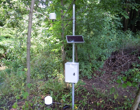
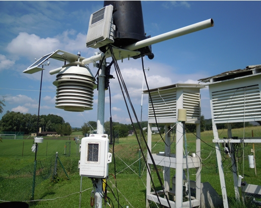
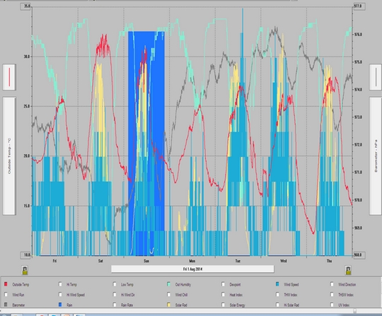
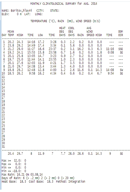
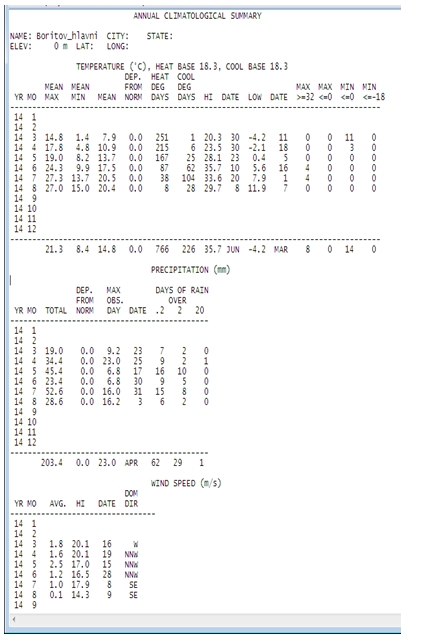
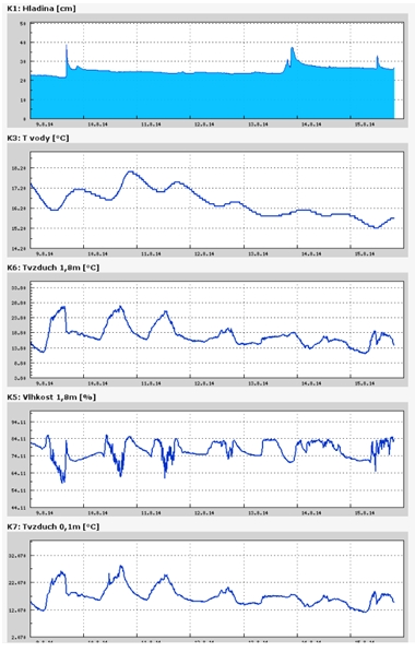
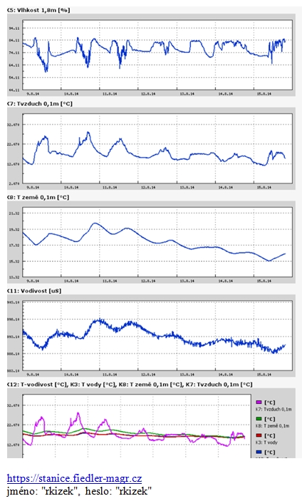
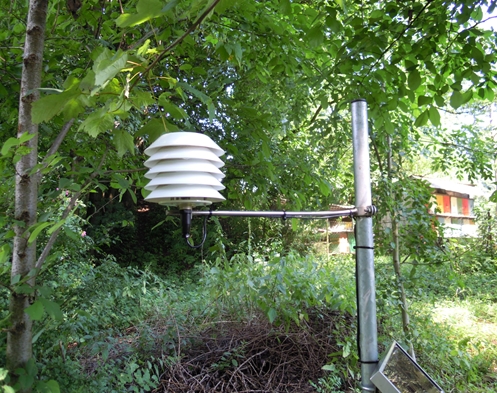 Meteorologická stanice sledující fyzikální parametry atmosféry a základní hydrologii Lysického potoka
 Cumulus mediocris, Cirostratus, Stratocumulus 10. 8 . 2014, 10:10 UTC, NEN,
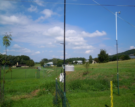
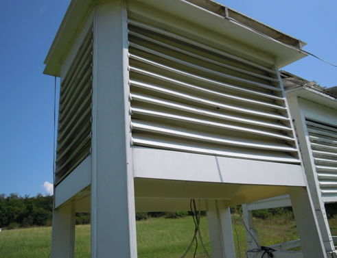 Standardní meteorologická budka – Bořitov 10. 8 .2014.
 Cirocumulus, cirus fibratua, cumulus humilis a cumulus mediocris. Foto 10. 8. 2014 v 10:11 UTC
NASA Satellite Spots a Weakening Karina, Now a Tropical Storm
 NASA's Terra satellite passed over Hurricane Karina before it weakened to a tropical storm early on August 15 and imagery showed the vertical wind shear was already taking its toll.
NASA's Terra satellite passed over Karina on August 14 at 2:40 p.m. EDT when it was still clinging to hurricane status and noticed that wind shear was already having an effect on the storm's structure. The Moderate Resolution Imaging Spectroradiometer or MODIS instrument captured an image that showed that the bulk of Karina's clouds were being pushed to the western side of the storm. That was an indication that vertical wind shear was moderate to strong and it continued weakening the storm.
On August 15, Karina continued to experience 20 to 25 knots of easterly vertical wind shear, which has caused the center to become partly exposed on the eastern side of the deep convection (rising air that forms the thunderstorms that make up the tropical storm).
A tropical storm has maximum sustained wind speed between 39 and 73 mph. By 5 a.m. EDT (0900 UTC) on August 15, Karina's maximum sustained winds had decreased to 70 mph (110 kph) and the National Hurricane Center expects additional weakening over the next two days.
Karina's center was located latitude 17.2 north and longitude 119.1 west, about 715 miles (1,150 km) west-southwest of the southern tip of Baja California, Mexico. Karina was moving toward the west near 12 mph (19 kph) and is expected to turn to the west-northwest. The estimated minimum central pressure is 990 millibars.
Wind shear is expected to decrease while Karina moves over sea surface temperatures of near 26C (80F). Tropical cyclones need sea surface temperatures of at least 26C/80F to maintain strength. The National Hurricane Center noted, "this could allow Karina to re-intensify as forecast by the GFDL and the Navy COAMPS computer forecast models. However, any deviation north of the forecast track would take the system over colder water, which would prevent strengthening."
NASA's Terra satellite passed over Hurricane Karina before it weakened to a tropical storm early on August 15 and imagery showed the vertical wind shear was already taking its toll.
NASA's Terra satellite passed over Karina on August 14 at 2:40 p.m. EDT when it was still clinging to hurricane status and noticed that wind shear was already having an effect on the storm's structure. The Moderate Resolution Imaging Spectroradiometer or MODIS instrument captured an image that showed that the bulk of Karina's clouds were being pushed to the western side of the storm. That was an indication that vertical wind shear was moderate to strong and it continued weakening the storm.
On August 15, Karina continued to experience 20 to 25 knots of easterly vertical wind shear, which has caused the center to become partly exposed on the eastern side of the deep convection (rising air that forms the thunderstorms that make up the tropical storm).
A tropical storm has maximum sustained wind speed between 39 and 73 mph. By 5 a.m. EDT (0900 UTC) on August 15, Karina's maximum sustained winds had decreased to 70 mph (110 kph) and the National Hurricane Center expects additional weakening over the next two days.
Karina's center was located latitude 17.2 north and longitude 119.1 west, about 715 miles (1,150 km) west-southwest of the southern tip of Baja California, Mexico. Karina was moving toward the west near 12 mph (19 kph) and is expected to turn to the west-northwest. The estimated minimum central pressure is 990 millibars.
Wind shear is expected to decrease while Karina moves over sea surface temperatures of near 26C (80F). Tropical cyclones need sea surface temperatures of at least 26C/80F to maintain strength. The National Hurricane Center noted, "this could allow Karina to re-intensify as forecast by the GFDL and the Navy COAMPS computer forecast models. However, any deviation north of the forecast track would take the system over colder water, which would prevent strengthening."
Tropical Storm Karina Forms in Eastern Pacific Near Socorro Island
Socorro Island in the Eastern Pacific received an unwelcome tropical visitor on the morning of August 13 when satellite data confirmed the formation of Tropical Storm Karina.
Karina strengthened from the eleventh tropical depression in the Eastern Pacific. Tropical Depression 11-E formed at 11 p.m. EDT on August 12. Just twelve hours later at 11 a.m. EDT, the depression had become better organized and winds increased to tropical storm strength.
NOAA's GOES-West satellite captured an infrared image of newborn Tropical Storm Karina approaching Socorro Island in the Eastern Pacific on August 13 at 1500 UTC (11 a.m. EDT). The GOES image was created by the NASA/NOAA GOES Project at NASA's Goddard Space Flight Center in Greenbelt, Maryland.
Forecaster Stewart at NOAA's National Hurricane Center noted that deep convection has continued to increase with cloud tops of -80C to -84C (-112F to -119.2F) just west of the low-level center. Infrared data is used to help determine cloud top temperatures. One of NASA's instruments that analyze tropical cyclones is the Atmospheric Infrared Sounder or AIRS instrument that flies aboard NASA's Aqua satellite.
In August 13 at 8 a.m. PDT (11 a.m. EDT/1500 UTC) the center of Tropical Storm Karina was located near latitude 17.2 north and longitude 111.0 west. That's about 110 miles (180 km) south of Socorro Island. Socorro is a small volcanic island and is part of Mexico's Revillagigedo Islands. It is located about 370 miles (600 km) west of mainland Mexico.
Karina's maximum sustained winds were near 40 mph (65 kph) and the National Hurricane Center (NHC) expects strengthening over the next two days as it moves west. The estimated minimum central pressure is 1005 millibars.
Despite the vertical wind shear that is currently affecting the system, it still managed to strengthen and organize into a tropical storm. The National Hurricane Center forecast calls for that wind shear to slowly subside over the next 4 to 5 days while the Karina remains over warm sea surface temperatures of 28-29C, so steady intensification appears likely. NHC expects Karina to reach hurricane strength on August 16.
Archiv
29_201429_2014
29_2014
28_2014
27_2014
26_2014
26_2014
25_2014
24_2014
23_2014
22_2014
21_2014
20_2014
20_2014
20_2014
19_2014
18_2014
17_2014
16_2014
15_2014
14_2014
54_2013
53_2013
52_2013
51_2013
50_2013
49_2013
48_2013
47_2013
46_2013
45_2013
44_2013
43_2013
42_2013
41_2013
40_2013
39_2013
38_2013
37_2013
36_2013
35_2013
34_2013
33_2013
32_2013
31_2013
30_2013
29_2013
28_2013
27_2013
26_2013
25_2013
24_2013
23_2013
22_2013
21_2013
20_2013
19_2013
18_2013
17_2013
16_2013
15_2013
14_2013
13_2013
12_2013
11_2013
10_2013
09_2013
08_2013
07_2013
06_2013
05_2013
04_2013
03_2013
02_2013
01_2013

 | Zemědělská 1/1665 613 00 Brno Budova D | Tel.: +420 545 133 350 Fax.: +420 545 212 044 |  |
 |