

Vědět a znát, to mnohý by chtěl, ale učit se nechce.
Walther Von Der Vegelweide
Konference
Konference v roce 2015
Konference v roce 2014
Konference v roce 2013
Konference v roce 2012
Konference v roce 2011


Polní laboratoř
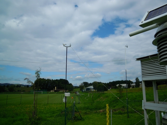
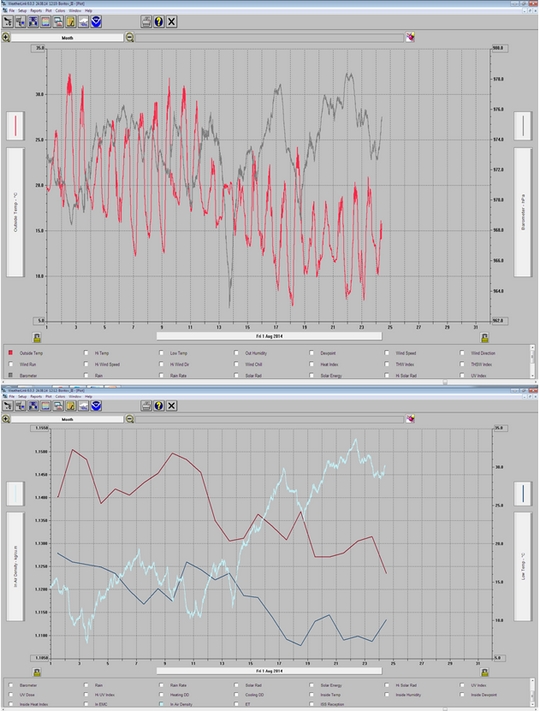
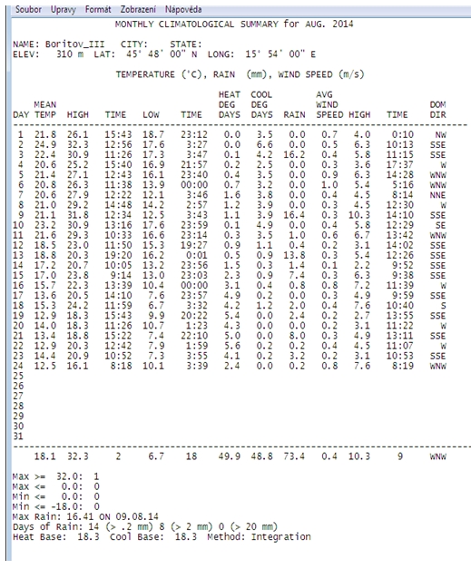
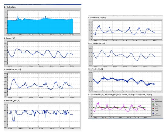
Informace z polní laboratoře – Bořitov
 Altocumulus 24. 8. 2014, 10:20 UTC, W
 Atocumulus, Altomumulus lenticularis, Stratocumulus 24. 8. 2014, 10:20 UTC, NWW
 Atocumulus, Altomumulus lenticularis, Stratocumulus 24. 8. 2014, 10:25 UTC, NWW
 Atocumulus, Altomumulus lenticularis, Stratocumulus 24. 8. 2014, 10:25 UTC, N
 Atocumulus, Altomumulus lenticularis, Stratocumulus 24. 8. 2014, 10:25 UTC, N
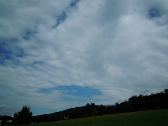 Atocumulus, Altomumulus lenticularis, Stratocumulus 24. 8. 2014, 10:25 UTC, N
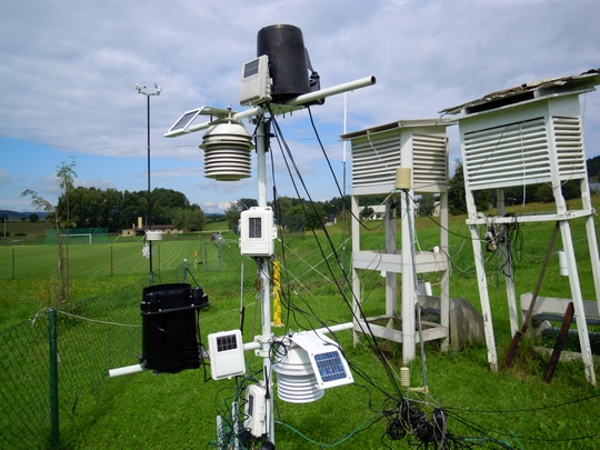
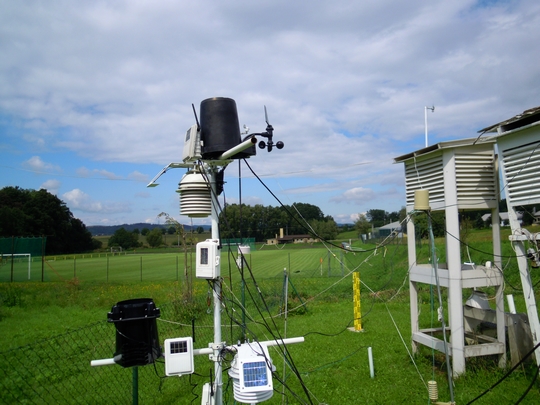
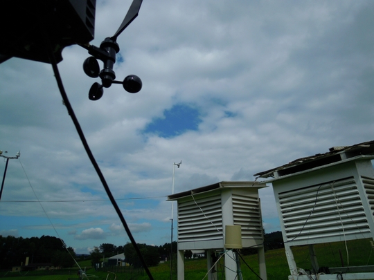
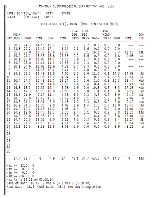
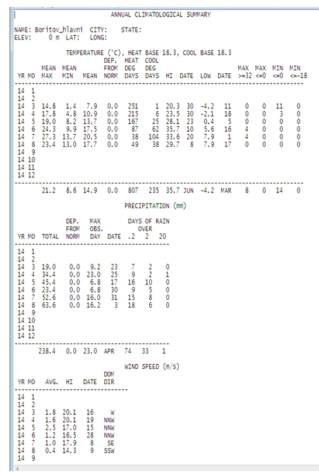
Meteorologické pozorování 1 m nad povrchem trávníku, Bořitov Hlavní stanice
Atocumulus, Altomumulus lenticularis, Stratocumulus 24. 8. 2014, 10:25 UTC, N
Meteorologické pozorování 1 m nad povrchem trávníku, Bořitov Hlavní stanice
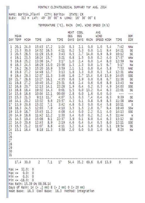
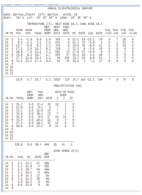
 Meteorologické pozorování 2 m nad povrchem trávníku, Bořitov Hlavní stanice
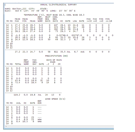
 Meteorologické pozorování, Bořitov letiště
Nimbostratus cloud
 Nimbostratus is a low-to-middle altitude cloud that has considerable vertical and horizontal extent and produces precipitation over a wide area. "Nimbo" is from the Latin word "nimbus", which denotes precipitation. It is a multilevel stratiform layer with a diffuse cloud base generally found anywhere from near surface and about 10000 ft (3000 m). This cloud typically forms from altostratus in the middle altitude range, but it tends to thicken into the low altitude range during precipitation. Although usually dark at its base, it often appears illuminated from within to a surface observer.[1] Nimbostratus usually has a thickness of about 2000 m. Though found worldwide, nimbostratus occurs more commonly in the middle latitudes.[2] Nimbostratus will occur along a warm front where the slowly rising warm air mass creates nimbostratus along with shallower stratus clouds producing less rain, these clouds being preceded by higher-level clouds such as cirrostratus and altostratus clouds.[3][4] Often, when an altostratus cloud thickens and descends into lower altitudes, it will become nimbostratus.[5]
Nimbostratus, unlike cumulonimbus, is not a
ss
ociated with thunderstorms, however at an unusually unstable warm front caused as a result of the advancing warm air being hot, humid and unstable, cumulonimbus clouds may be embedded within the usual nimbostratus. Lightning from an embedded cumulonimbus cloud may interact with the nimbostratus but only in the immediate area around it. In this situation with lightning and rain occurring it would be hard to tell which type of cloud was producing the rain from the ground, however cumulonimbus tend to produce larger droplets and more intense downpours. The occurrence of cumulonimbus and nimbostratus together is uncommon, and usually only nimbostratus is found at a warm front. Nimbostratus fractus is a variation of nimbostratus and will sometimes occur as a weather front clears, these being areas of dark rain bearing clouds with lighter altostratus between.
Lowell is now a large hurricane in the Eastern Pacific and NASA's Aqua and Terra satellites double-teamed it to provide infrared and radar data to scientists. Lowell strengthened into a hurricane during the morning hours of August 21.
When NASA's Aqua satellite passed over Lowell on August 20 at 21:05 UTC (4:05 p.m. EDT), the Atmospheric Infrared Sounder got an infrared look at Lowell's cloud top temperatures when it was still a tropical storm. AIRS showed a very thick band of thunderstorms surrounding the center of circulation and what appeared to be a very small cloud-free center of circulation, like the formation of an eye. Cloud top temperatures exceeded -63F/-52C, the threshold for high, cold thunderstorms with the potential for dropping heavy rainfall.
Nimbostratus is a low-to-middle altitude cloud that has considerable vertical and horizontal extent and produces precipitation over a wide area. "Nimbo" is from the Latin word "nimbus", which denotes precipitation. It is a multilevel stratiform layer with a diffuse cloud base generally found anywhere from near surface and about 10000 ft (3000 m). This cloud typically forms from altostratus in the middle altitude range, but it tends to thicken into the low altitude range during precipitation. Although usually dark at its base, it often appears illuminated from within to a surface observer.[1] Nimbostratus usually has a thickness of about 2000 m. Though found worldwide, nimbostratus occurs more commonly in the middle latitudes.[2] Nimbostratus will occur along a warm front where the slowly rising warm air mass creates nimbostratus along with shallower stratus clouds producing less rain, these clouds being preceded by higher-level clouds such as cirrostratus and altostratus clouds.[3][4] Often, when an altostratus cloud thickens and descends into lower altitudes, it will become nimbostratus.[5]
Nimbostratus, unlike cumulonimbus, is not a
ss
ociated with thunderstorms, however at an unusually unstable warm front caused as a result of the advancing warm air being hot, humid and unstable, cumulonimbus clouds may be embedded within the usual nimbostratus. Lightning from an embedded cumulonimbus cloud may interact with the nimbostratus but only in the immediate area around it. In this situation with lightning and rain occurring it would be hard to tell which type of cloud was producing the rain from the ground, however cumulonimbus tend to produce larger droplets and more intense downpours. The occurrence of cumulonimbus and nimbostratus together is uncommon, and usually only nimbostratus is found at a warm front. Nimbostratus fractus is a variation of nimbostratus and will sometimes occur as a weather front clears, these being areas of dark rain bearing clouds with lighter altostratus between.
Lowell is now a large hurricane in the Eastern Pacific and NASA's Aqua and Terra satellites double-teamed it to provide infrared and radar data to scientists. Lowell strengthened into a hurricane during the morning hours of August 21.
When NASA's Aqua satellite passed over Lowell on August 20 at 21:05 UTC (4:05 p.m. EDT), the Atmospheric Infrared Sounder got an infrared look at Lowell's cloud top temperatures when it was still a tropical storm. AIRS showed a very thick band of thunderstorms surrounding the center of circulation and what appeared to be a very small cloud-free center of circulation, like the formation of an eye. Cloud top temperatures exceeded -63F/-52C, the threshold for high, cold thunderstorms with the potential for dropping heavy rainfall.
Archiv
32_201431_2014
30_2014
29_2014
29_2014
28_2014
27_2014
26_2014
26_2014
25_2014
24_2014
23_2014
22_2014
21_2014
20_2014
20_2014
20_2014
19_2014
18_2014
17_2014
16_2014
15_2014
14_2014
54_2013
53_2013
52_2013
51_2013
50_2013
49_2013
48_2013
47_2013
46_2013
45_2013
44_2013
43_2013
42_2013
41_2013
40_2013
39_2013
38_2013
37_2013
36_2013
35_2013
34_2013
33_2013
32_2013
31_2013
30_2013
29_2013
28_2013
27_2013
26_2013
25_2013
24_2013
23_2013
22_2013
21_2013
20_2013
19_2013
18_2013
17_2013
16_2013
15_2013
14_2013
13_2013
12_2013
11_2013
10_2013
09_2013
08_2013
07_2013
06_2013
05_2013
04_2013
03_2013
02_2013
01_2013

 | Zemědělská 1/1665 613 00 Brno Budova D | Tel.: +420 545 133 350 Fax.: +420 545 212 044 |  |
 |