

Důkazem vysokého vzdělání je schopnost mluvit o největších věcech nejjednodušším způsobem.
David Hume
Konference
Konference v roce 2015
Konference v roce 2014
Konference v roce 2013
Konference v roce 2012
Konference v roce 2011


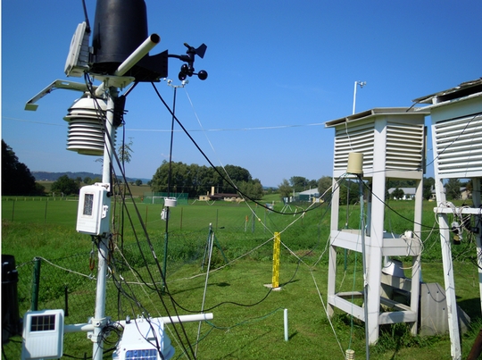
Polní laboratoř
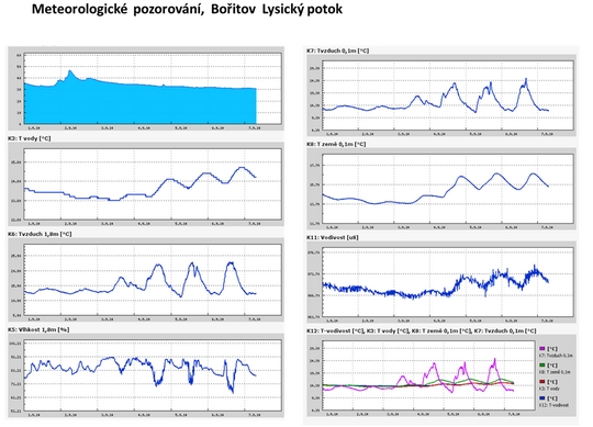
Informace z polní laboratoře – Bořitov
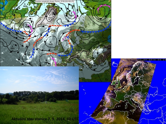
 Aktuální stav stanice 7. 9. 2014

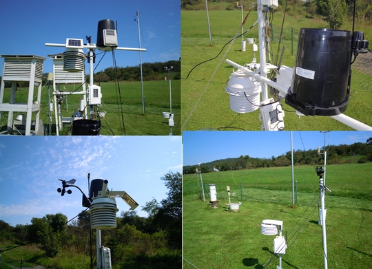
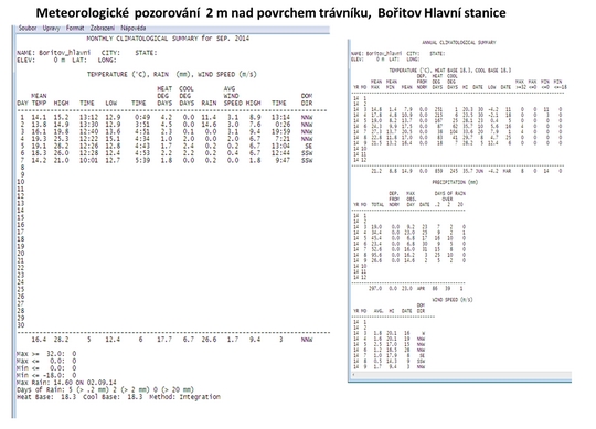
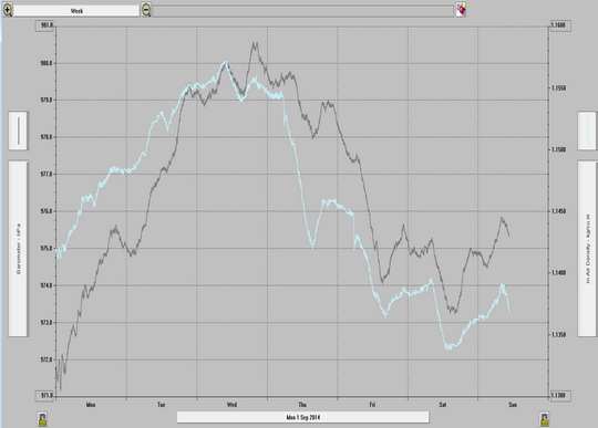
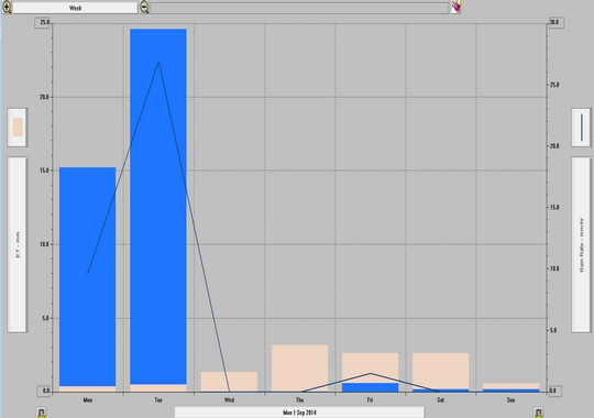
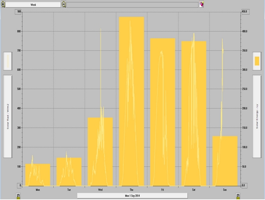
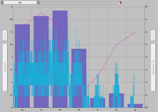
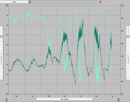
 Meteorologické pozorování 2 m nad povrchem trávníku, Bořitov Hlavní stanice
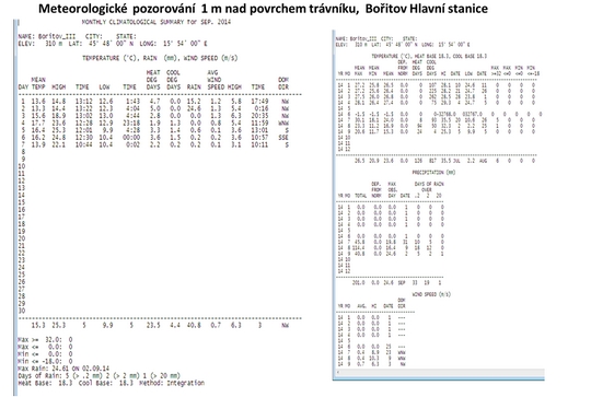

 Meteorologické pozorování 2 m nad povrchem trávníku, Bořitov Hlavní stanice


NASA Sees Large Tropical Storm Fengshen Skirting Eastern Japan's Coastline
 Tropical Storm Fengshen is a large storm and infrared imagery from NASA's Aqua satellite shows that it's about as long as the big island of Japan.
NASA's Aqua satellite passed over Tropical Storm Fengshen on September 7 and the Atmospheric Infrared Sounder instrument known as AIRS gathered temperature data about the storm's cloud tops and surrounding sea surface temperatures. The infrared data showed strong thunderstorms surrounded the center of circulation and also appeared in large bands south and northeast of the storm's center. Another large and fragmented band on strong thunderstorms stretched to the northeast of the center of the storm and ran northeastward along Japan's east coast.
On September 8 at 1500 UTC (11 a.m. EDT), Tropical Storm Fengshen had maximum sustained winds near 55 knots (63.2 mph/102 kph). It was moving to the east-northeast at 23 knots (26.4 mph/42.6 kph) and away from the big island of Japan. Fengshen was centered near 31.4 north latitude and 140.6 east longitude about 264 nautical miles (303 miles/488.9 km) south of Yokosuka, Japan. For a list of warnings in Japan, visit the Japan Meteorological Agency website: http://www.jma.go.jp/en/warn/.
Microwave satellite data on September 8, showed an eye with strong thunderstorms banding north of the center of circulation and wrapping into it. That microwave data was taken from the MetOp-B satellite. MetOp is a series of three polar orbiting meteorological satellites operated by the European Organisation for the Exploitation of Meteorological Satellites (EUMETSAT).
Fengshen is expected to intensify to typhoon strength before undergoing extra-tropical transitioning as it continues to move east and away from Japan.
Tropical Storm Fengshen is a large storm and infrared imagery from NASA's Aqua satellite shows that it's about as long as the big island of Japan.
NASA's Aqua satellite passed over Tropical Storm Fengshen on September 7 and the Atmospheric Infrared Sounder instrument known as AIRS gathered temperature data about the storm's cloud tops and surrounding sea surface temperatures. The infrared data showed strong thunderstorms surrounded the center of circulation and also appeared in large bands south and northeast of the storm's center. Another large and fragmented band on strong thunderstorms stretched to the northeast of the center of the storm and ran northeastward along Japan's east coast.
On September 8 at 1500 UTC (11 a.m. EDT), Tropical Storm Fengshen had maximum sustained winds near 55 knots (63.2 mph/102 kph). It was moving to the east-northeast at 23 knots (26.4 mph/42.6 kph) and away from the big island of Japan. Fengshen was centered near 31.4 north latitude and 140.6 east longitude about 264 nautical miles (303 miles/488.9 km) south of Yokosuka, Japan. For a list of warnings in Japan, visit the Japan Meteorological Agency website: http://www.jma.go.jp/en/warn/.
Microwave satellite data on September 8, showed an eye with strong thunderstorms banding north of the center of circulation and wrapping into it. That microwave data was taken from the MetOp-B satellite. MetOp is a series of three polar orbiting meteorological satellites operated by the European Organisation for the Exploitation of Meteorological Satellites (EUMETSAT).
Fengshen is expected to intensify to typhoon strength before undergoing extra-tropical transitioning as it continues to move east and away from Japan.
Sept. 08, 2014 - NASA Catches the End of Tropical Depression 14W
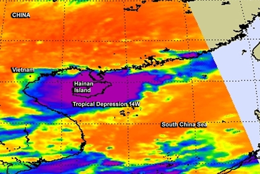 Tropical Depression 14W was a short-lived storm that only lasted through four bulletins from the Joint Typhoon Warning Center. NASA's Aqua satellite captured infrared data on the storm's cloud top temperatures as it passed over China's Hainan Island and headed toward a final landfall in mainland China.
Born in the South China Sea it made landfall in southeastern China on September 8. The Atmospheric Infrared Sounder instrument called AIRS that flies aboard NASA's Aqua satellite captured infrared data on the storm on September 7 at 1:59 a.m. EDT. The AIRS data showed an elongated storm over Hainan Island, China. It also showed cold cloud top temperatures near -63F/-52C that indicated powerful thunderstorms dropping heavy rainfall over the island.
The final warning on Tropical Depression 14W (TD14W) was issued on September 8 at 0300 UTC (September 7 at 11 p.m. EDT). AT that time, the center of the depression was near 21.1 north latitude and 111.2 east longitude about 182 miles (293 km) west-southwest of Hong Kong, China. It was moving to the north-northwest at 13 knots (14.9 mph/24.8 kph) and maximum sustained winds were near 25 knots (28.7 mph/46.3 kph) and waning.
As TD14W made landfall on September 8 it brought wave heights up to 6 feet (1.8 meters) along coastal areas of southern China. Satellite imagery showed that the remnants of the depression were moving over the northern Gulf of Tonkin, located to the west of Hainan Island and are expected to continue in a north-northwesterly direction until dissipation.
Tropical Depression 14W was a short-lived storm that only lasted through four bulletins from the Joint Typhoon Warning Center. NASA's Aqua satellite captured infrared data on the storm's cloud top temperatures as it passed over China's Hainan Island and headed toward a final landfall in mainland China.
Born in the South China Sea it made landfall in southeastern China on September 8. The Atmospheric Infrared Sounder instrument called AIRS that flies aboard NASA's Aqua satellite captured infrared data on the storm on September 7 at 1:59 a.m. EDT. The AIRS data showed an elongated storm over Hainan Island, China. It also showed cold cloud top temperatures near -63F/-52C that indicated powerful thunderstorms dropping heavy rainfall over the island.
The final warning on Tropical Depression 14W (TD14W) was issued on September 8 at 0300 UTC (September 7 at 11 p.m. EDT). AT that time, the center of the depression was near 21.1 north latitude and 111.2 east longitude about 182 miles (293 km) west-southwest of Hong Kong, China. It was moving to the north-northwest at 13 knots (14.9 mph/24.8 kph) and maximum sustained winds were near 25 knots (28.7 mph/46.3 kph) and waning.
As TD14W made landfall on September 8 it brought wave heights up to 6 feet (1.8 meters) along coastal areas of southern China. Satellite imagery showed that the remnants of the depression were moving over the northern Gulf of Tonkin, located to the west of Hainan Island and are expected to continue in a north-northwesterly direction until dissipation.
NASA Catches Birth of Tropical Storm Odile
 The Eastern Pacific Ocean continues to turn out tropical cyclones and NASA's Aqua satellite caught the birth of the fifteenth tropical depression on September 10 and shortly afterward, it strengthened into a tropical storm and was renamed Odile.
The Atmospheric Infrared Sounder or AIRS instrument that flies aboard NASA's Aqua satellite captured infrared data on Tropical Depression 15-E on September 10 at 8:53 UTC (4:53 a.m. EDT) when it developed. The National Hurricane Center named the depression at 5 a.m. EDT, when the center was located near latitude 14.4 north and longitude 102.5 west.
AIRS infrared imagery reads temperature and identified the coldest temperatures in powerful thunderstorms circling the center of the newborn depression. Cloud top temperatures were near 220 kelvin (-63.6F/-53.1C).
By 11 a.m. EDT, the depression strengthened into Tropical Storm Odile. Maximum sustained winds were near 40 mph (65 kph) and Odile was drifting toward the north-northwest near 3 mph (6 kph) and is expected to drift to the north-northwest over the next two days. Odile was located near 14.9 north latitude and 102.9 west longitude, about 220 miles (350 km) south-southwest of Lazaro Cardenas, Mexico.
The National Hurricane Center noted that on the forecast track, Odile's center will remain offshore of the southwestern coast of Mexico through Thursday night, September 11. However, Odile is expected to create swells, rip currents and rough surf along the southwestern coast of Mexico over the next day or two.
The Eastern Pacific Ocean continues to turn out tropical cyclones and NASA's Aqua satellite caught the birth of the fifteenth tropical depression on September 10 and shortly afterward, it strengthened into a tropical storm and was renamed Odile.
The Atmospheric Infrared Sounder or AIRS instrument that flies aboard NASA's Aqua satellite captured infrared data on Tropical Depression 15-E on September 10 at 8:53 UTC (4:53 a.m. EDT) when it developed. The National Hurricane Center named the depression at 5 a.m. EDT, when the center was located near latitude 14.4 north and longitude 102.5 west.
AIRS infrared imagery reads temperature and identified the coldest temperatures in powerful thunderstorms circling the center of the newborn depression. Cloud top temperatures were near 220 kelvin (-63.6F/-53.1C).
By 11 a.m. EDT, the depression strengthened into Tropical Storm Odile. Maximum sustained winds were near 40 mph (65 kph) and Odile was drifting toward the north-northwest near 3 mph (6 kph) and is expected to drift to the north-northwest over the next two days. Odile was located near 14.9 north latitude and 102.9 west longitude, about 220 miles (350 km) south-southwest of Lazaro Cardenas, Mexico.
The National Hurricane Center noted that on the forecast track, Odile's center will remain offshore of the southwestern coast of Mexico through Thursday night, September 11. However, Odile is expected to create swells, rip currents and rough surf along the southwestern coast of Mexico over the next day or two.
Archiv
34_201433_2014
32_2014
31_2014
30_2014
29_2014
29_2014
28_2014
27_2014
26_2014
26_2014
25_2014
24_2014
23_2014
22_2014
21_2014
20_2014
20_2014
20_2014
19_2014
18_2014
17_2014
16_2014
15_2014
14_2014
54_2013
53_2013
52_2013
51_2013
50_2013
49_2013
48_2013
47_2013
46_2013
45_2013
44_2013
43_2013
42_2013
41_2013
40_2013
39_2013
38_2013
37_2013
36_2013
35_2013
34_2013
33_2013
32_2013
31_2013
30_2013
29_2013
28_2013
27_2013
26_2013
25_2013
24_2013
23_2013
22_2013
21_2013
20_2013
19_2013
18_2013
17_2013
16_2013
15_2013
14_2013
13_2013
12_2013
11_2013
10_2013
09_2013
08_2013
07_2013
06_2013
05_2013
04_2013
03_2013
02_2013
01_2013

 | Zemědělská 1/1665 613 00 Brno Budova D | Tel.: +420 545 133 350 Fax.: +420 545 212 044 |  |
 |