

Tajemství vládnutí spočívá totiž v tom, jak spojit víru ve vlastní neomylnost se schopností učit se z minulých chyb.
George Orwell
Konference
Konference v roce 2015
Konference v roce 2014
Konference v roce 2013
Konference v roce 2012
Konference v roce 2011


Polní laboratoř
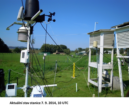
Informace z polní laboratoře – Bořitov
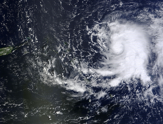
Satellites Confirm Fay Weakened to a Tropical Storm
 The fifth named Atlantic storm didn't maintain hurricane status long. Fay became a hurricane late on Oct. 12 and by early on Oct. 13, had weakened back to a tropical storm.
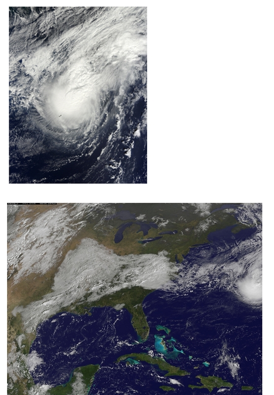
A visible image from NOAA's GOES-East satellite on Oct. 13 at 1145 UTC (7:45 a.m. EDT) showed Tropical Storm Fay northeast of Bermuda and Tropical Storm Gonzalo over the Lesser Antilles. Fay appeared circular, but didn't have the signature shape of a tropical storm like Gonzalo, with bands of thunderstorms spiraling into the center. The image was created by the NASA/NOAA GOES Project at NASA's Goddard Space Flight Center in Greenbelt, Maryland.
The National Hurricane Center noted that microwave imagery showed Fay has begun extra-tropical transition. NHC discussion said: The cloud pattern has become quite asymmetric and the remaining central deep convection, situated well to the northeast of the center of circulation, is decreasing. At 5 a.m. EDT on Oct. 13, Tropical Storm Fay's maximum sustained winds were near 65 mph (100 kph) and gradually weakening. It was centered near latitude 34.3 north and longitude 55.3 west. Fay was about 565 miles (910 km) east-northeast of Bermuda and moving to the east at 26 mph (43 kph)..
The NHC expects Fay to merge with a frontal zone and become an extra-tropical cyclone by tonight, Oct. 13.
The fifth named Atlantic storm didn't maintain hurricane status long. Fay became a hurricane late on Oct. 12 and by early on Oct. 13, had weakened back to a tropical storm.
A visible image from NOAA's GOES-East satellite on Oct. 13 at 1145 UTC (7:45 a.m. EDT) showed Tropical Storm Fay northeast of Bermuda and Tropical Storm Gonzalo over the Lesser Antilles. Fay appeared circular, but didn't have the signature shape of a tropical storm like Gonzalo, with bands of thunderstorms spiraling into the center. The image was created by the NASA/NOAA GOES Project at NASA's Goddard Space Flight Center in Greenbelt, Maryland.
The National Hurricane Center noted that microwave imagery showed Fay has begun extra-tropical transition. NHC discussion said: The cloud pattern has become quite asymmetric and the remaining central deep convection, situated well to the northeast of the center of circulation, is decreasing. At 5 a.m. EDT on Oct. 13, Tropical Storm Fay's maximum sustained winds were near 65 mph (100 kph) and gradually weakening. It was centered near latitude 34.3 north and longitude 55.3 west. Fay was about 565 miles (910 km) east-northeast of Bermuda and moving to the east at 26 mph (43 kph)..
The NHC expects Fay to merge with a frontal zone and become an extra-tropical cyclone by tonight, Oct. 13.
Tropical Storm Gonzalo Triggered Many Warnings in Eastern Caribbean
 The Eastern Caribbean islands were getting the brunt of Tropical Storm Gonzalo as the storm slowly moved through on Oct. 13. NASA's Terra satellite and NOAA's GOES-East satellite provided data on the storm. Gonzalo is the sixth named storm in the Atlantic Ocean Hurricane Season.
On Oct. 12 at 15:00 UTC (11:00 a.m. EDT), NASA's Terra satellite flew over Tropical Storm Gonzalo while it moved over the Lesser Antilles. The MODIS instrument captured a visible image of the storm that showed a concentration of strong thunderstorms around the center of circulation and in a thick band east of the center.
A visible image from NOAA's GOES-East satellite on Oct. 13 at 1145 UTC (7:45 a.m. EDT) showed Tropical Storm Fay northeast of Bermuda and Tropical Storm Gonzalo over the Lesser Antilles. Fay appeared circular, but didn't have the signature shape of a tropical storm like Gonzalo, with bands of thunderstorms spiraling into the center. The image was created by the NASA/NOAA GOES Project at NASA's Goddard Space Flight Center in Greenbelt, Maryland.
Gonzalo is over the Lesser Antilles and affecting many eastern Caribbean islands so there are many warnings and watches in effect. The National Hurricane Center (NHC) noted the following: A Hurricane Watch is in effect for Puerto Rico, Vieques and Culebra, U.S. Virgin Islands, British Virgin Islands. A Tropical Storm Warning is in effect for Guadeloupe, Desirade, Les Saintes, and Marie Galante, St. Martin, St. Barthelemy, St. Maartin, Saba and St. Eustatius, Barbuda, Antigua, Anguilla, St. Kitts And Nevis, Montserrat, Puerto Rico, Vieques and Culebra, U.S. Virgin Islands and the British Virgin Islands.
A hurricane watch means that hurricane conditions are possible within the watch area, in this case in the next 24 hours. A tropical storm warning means that tropical storm conditions are expected somewhere within the warning area.
On Monday, Oct. 13 at 8 a.m. EDT, Tropical Storm Gonzalo had maximum sustained winds near 60 mph (95 kph). The National Hurricane Center expects strengthening during the next 48 hours and Gonzalo is forecast to become a hurricane tonight or Tuesday, Oct. 14. The center of Gonzalo was located near latitude 17.0 north and longitude 61.5 west. That's about 20 miles (35 km) east-southeast of Antigua and about 50 miles (75 km) north of Guadeloupe.
The Eastern Caribbean islands were getting the brunt of Tropical Storm Gonzalo as the storm slowly moved through on Oct. 13. NASA's Terra satellite and NOAA's GOES-East satellite provided data on the storm. Gonzalo is the sixth named storm in the Atlantic Ocean Hurricane Season.
On Oct. 12 at 15:00 UTC (11:00 a.m. EDT), NASA's Terra satellite flew over Tropical Storm Gonzalo while it moved over the Lesser Antilles. The MODIS instrument captured a visible image of the storm that showed a concentration of strong thunderstorms around the center of circulation and in a thick band east of the center.
A visible image from NOAA's GOES-East satellite on Oct. 13 at 1145 UTC (7:45 a.m. EDT) showed Tropical Storm Fay northeast of Bermuda and Tropical Storm Gonzalo over the Lesser Antilles. Fay appeared circular, but didn't have the signature shape of a tropical storm like Gonzalo, with bands of thunderstorms spiraling into the center. The image was created by the NASA/NOAA GOES Project at NASA's Goddard Space Flight Center in Greenbelt, Maryland.
Gonzalo is over the Lesser Antilles and affecting many eastern Caribbean islands so there are many warnings and watches in effect. The National Hurricane Center (NHC) noted the following: A Hurricane Watch is in effect for Puerto Rico, Vieques and Culebra, U.S. Virgin Islands, British Virgin Islands. A Tropical Storm Warning is in effect for Guadeloupe, Desirade, Les Saintes, and Marie Galante, St. Martin, St. Barthelemy, St. Maartin, Saba and St. Eustatius, Barbuda, Antigua, Anguilla, St. Kitts And Nevis, Montserrat, Puerto Rico, Vieques and Culebra, U.S. Virgin Islands and the British Virgin Islands.
A hurricane watch means that hurricane conditions are possible within the watch area, in this case in the next 24 hours. A tropical storm warning means that tropical storm conditions are expected somewhere within the warning area.
On Monday, Oct. 13 at 8 a.m. EDT, Tropical Storm Gonzalo had maximum sustained winds near 60 mph (95 kph). The National Hurricane Center expects strengthening during the next 48 hours and Gonzalo is forecast to become a hurricane tonight or Tuesday, Oct. 14. The center of Gonzalo was located near latitude 17.0 north and longitude 61.5 west. That's about 20 miles (35 km) east-southeast of Antigua and about 50 miles (75 km) north of Guadeloupe.
NASA Satellite Sees Wind Shear Affecting Tropical Storm Vongfong
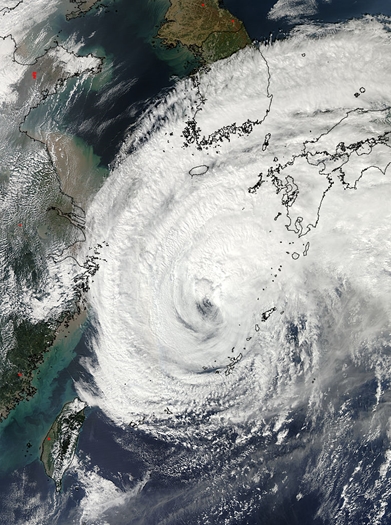 Tropical Storm Vongfong continues to weaken as it tracks across the big islands of Japan, and NASA satellite data showed that westerly wind shear is taking its toll on the storm's structure.
On Oct. 12 at 0500 UTC (1 a.m. EDT), the MODIS instrument aboard NASA's Aqua satellite captured an image of Tropical Storm Vongfong approaching Japan. Despite weakening to a tropical storm, Vongfong still appeared to have an eye as its northeastern quadrant blanketed the large island of Kyushu, Japan. By 11 a.m. EDT, Maximum sustained winds had dropped to 55 knots (63 mph/102 kph). Vongfong was centered near 30.2 north latitude and 128.2 east longitude. That's about 231 nautical miles south-southwest of Sasebo, Japan.
On Monday, Oct. 13 at 04:05 UTC (12:05 a.m. EDT), Aqua flew over Vongfong again, and the MODIS instrument aboard saw that most of the clouds and showers were being pushed to the east of the storm by wind shear. At 0900 UTC (5 a.m. EDT), Vongfong's maximum sustained winds were down to 45 knots (51.7 mph/83.3 kph). The center of Vongfong were near 33.8 north latitude and 134.1 east longitude, about 84 nautical miles south-southeast of Iwakuni, Japan. Vongfong was moving to the northeast at 23 knots (26.4 mph/42.6 kph).
Forecasters at the Joint Typhoon Warning Center (JTWC) noted that the storm's low-level center was exposed to outside winds, an indication that the storm could weaken. The strongest thunderstorms (a tropical cyclone is made up of hundreds of them) were isolated in the eastern quadrant of the storm as a result of strong vertical wind shear. Winds buffeting the storm from the west were blowing as high as 50 knots, pushing those thunderstorms east of the center.
JTWC reported surface observations across Shikoku indicated light core winds. However, winds are stronger along the Shikoku coast sustained up to 35 knots (40 mph/65 kph) with isolated gusts to 56 knots (64.4 mph/103.7 kph) in the southeastern coast.
Vongfong is expected to become extra-tropical and continue moving northeast over Japan and exiting back into the western North Pacific on Oct. 14.
Tropical Storm Vongfong continues to weaken as it tracks across the big islands of Japan, and NASA satellite data showed that westerly wind shear is taking its toll on the storm's structure.
On Oct. 12 at 0500 UTC (1 a.m. EDT), the MODIS instrument aboard NASA's Aqua satellite captured an image of Tropical Storm Vongfong approaching Japan. Despite weakening to a tropical storm, Vongfong still appeared to have an eye as its northeastern quadrant blanketed the large island of Kyushu, Japan. By 11 a.m. EDT, Maximum sustained winds had dropped to 55 knots (63 mph/102 kph). Vongfong was centered near 30.2 north latitude and 128.2 east longitude. That's about 231 nautical miles south-southwest of Sasebo, Japan.
On Monday, Oct. 13 at 04:05 UTC (12:05 a.m. EDT), Aqua flew over Vongfong again, and the MODIS instrument aboard saw that most of the clouds and showers were being pushed to the east of the storm by wind shear. At 0900 UTC (5 a.m. EDT), Vongfong's maximum sustained winds were down to 45 knots (51.7 mph/83.3 kph). The center of Vongfong were near 33.8 north latitude and 134.1 east longitude, about 84 nautical miles south-southeast of Iwakuni, Japan. Vongfong was moving to the northeast at 23 knots (26.4 mph/42.6 kph).
Forecasters at the Joint Typhoon Warning Center (JTWC) noted that the storm's low-level center was exposed to outside winds, an indication that the storm could weaken. The strongest thunderstorms (a tropical cyclone is made up of hundreds of them) were isolated in the eastern quadrant of the storm as a result of strong vertical wind shear. Winds buffeting the storm from the west were blowing as high as 50 knots, pushing those thunderstorms east of the center.
JTWC reported surface observations across Shikoku indicated light core winds. However, winds are stronger along the Shikoku coast sustained up to 35 knots (40 mph/65 kph) with isolated gusts to 56 knots (64.4 mph/103.7 kph) in the southeastern coast.
Vongfong is expected to become extra-tropical and continue moving northeast over Japan and exiting back into the western North Pacific on Oct. 14.
Archiv
36_201435_2014
34_2014
33_2014
32_2014
31_2014
30_2014
29_2014
29_2014
28_2014
27_2014
26_2014
26_2014
25_2014
24_2014
23_2014
22_2014
21_2014
20_2014
20_2014
20_2014
19_2014
18_2014
17_2014
16_2014
15_2014
14_2014
54_2013
53_2013
52_2013
51_2013
50_2013
49_2013
48_2013
47_2013
46_2013
45_2013
44_2013
43_2013
42_2013
41_2013
40_2013
39_2013
38_2013
37_2013
36_2013
35_2013
34_2013
33_2013
32_2013
31_2013
30_2013
29_2013
28_2013
27_2013
26_2013
25_2013
24_2013
23_2013
22_2013
21_2013
20_2013
19_2013
18_2013
17_2013
16_2013
15_2013
14_2013
13_2013
12_2013
11_2013
10_2013
09_2013
08_2013
07_2013
06_2013
05_2013
04_2013
03_2013
02_2013
01_2013

 | Zemědělská 1/1665 613 00 Brno Budova D | Tel.: +420 545 133 350 Fax.: +420 545 212 044 |  |
 |